
Where Flight Simulation Enthusiasts Gather from Around the World!
AVSIM Library - Search Results

| Category: Flight Simulator X - AI Aircraft | |
| Vietnam War project - airplanes pack |

|
Images related to this file:
File Description:

FSX Vietnam War Project - AI Airplanes pack for FSX Vietnam War project. FSX SP1/SP2 needed - Acceleration Pack optional, recommended.
About 30 AI aiplanes (A-1 Skyraider, C-123 provider, EC-121...). Requires the FSX Vietnam War project (scenery base pack V 0.9 uploaded separately: VnW_09.zip).
Visit the project web site: http://vietnamwar.project.free.fr/.
To contact us: [email protected]
FSX Vietnam War project: Jacques Godfrin - Xavier Carre
| Filename: | Vietnam_War_project__airplanes_pack.zip |
| License: | Freeware, limited distribution |
| Added: | 11th April 2010, 08:01:39 |
| Downloads: | 2,520 |
| Author: | Jacques Godfrin, Xavier Carre, Vietnam War project |
| Size: | 66.21 MB |
| Category: Flight Simulator 2002 - AFCAD Files | |
| AFCAD GCFV Fuerteventura for Aerosoft Scenery |
|
File Description:
This AFCAD file adds gates and parking areas and updates all taxiways for GCFV to use with Aerosoft´s "Canaris Islands" Scenery. Also works with Fuerteventura scenery (stand alone) To use with Project AI planes highly recommended.
| Filename: | AFCAD_GCFV_Fuerteventura_for_Aerosoft_Scenery.zip |
| License: | Freeware |
| Added: | 20th November 2002, 20:47:04 |
| Downloads: | 601 |
| Author: | Claudius Karch |
| Size: | 12.81 KB |
| Category: Flight Simulator 2004 - AFCAD Files | |
| London Stansted (EGSSJY5.ZIP) |
|
File Description:
Adds the gates and aligns the AI traffic to my London Stansted scenery Version 5. Although this scenery was designed for FS2002, it works equally well in FS2004. Stand coding is to the Project AI standard for consistency.
| Filename: | London_Stansted_EGSSJY5ZIP.zip |
| License: | Freeware |
| Added: | 9th November 2003, 23:14:33 |
| Downloads: | 2,909 |
| Author: | John Young |
| Size: | 31.03 KB |
| Category: Flight Simulator 2004 - AFCAD Files | |
| Kerkyra Airport |
|
File Description:
AFCAD2 file for LGKR - Kerkyra Airport. For use with the freeware scenery Kerkira Project 2003 by Sakis Vlachopoulos and Nikos Dimitratos only! Version 0.9.
| Filename: | Kerkyra_Airport.zip |
| License: | Freeware |
| Added: | 28th October 2003, 15:33:48 |
| Downloads: | 1,440 |
| Author: | Felix Hippmann |
| Size: | 3.86 KB |
| Category: Flight Simulator X - Aircraft Repaints, Textures and Modifications | |
| 8 Greek airlines - (package) Boeing 737-400 |
|
Images related to this file:
File Description:
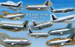
These is a Hellenic repaints package(textures only) for the payware Wilco - 737 Pilot In Command X.
These textures represent 11 aircraft of 8 Greek companies that used to fly over Hellas with 737-400 : Olympic Airlines(SX-BKD, SX-BKX, SX-BKG, SX-BKC), Olympic Airways (SX-BKA), Aegean Airlines (SX-BGV), Macedonian Airlines (SX-BMA), Air Miles (TF-ELV), Axon Airlines (SX-BLM), Cronus Airlines (SX-BGH) and Galaxy Airlines (SX-BFV).
| Filename: | 8_Greek_airlines__package__Boeing_737400.zip |
| License: | Freeware |
| Added: | 19th November 2011, 23:39:01 |
| Downloads: | 1,350 |
| Author: | Astrios Tso |
| Size: | 21.1 MB |
| Category: Fly! II - TerraScene | |
| Johnson City (Carolinas Project) TerraScene Project Pack |
|
Images related to this file:
File Description:
This TerraScene 2.1 Project pack covers all of global tile 197,155, centering on Johnson City and Elizabethton, TN. Following the Cherokee and Pisgah National Forests to the southwest takes you through Greenville, TN into the Smokies. This tile includes Kingsport, TN to the north and Morganton, NC to the east. This pack includes updated Tiger Census (2000) shapefile data, adding new water areas, new highways, and other details. All scenery data files are included: USGS data, shapefiles, and a complete custom water mask. Requires TerraScene 2.1 and Fly!II patched to v230 or later.
| Filename: | Johnson_City_Carolinas_Project_TerraScene_Project_.zip |
| License: | Freeware |
| Added: | 9th May 2010, 00:58:40 |
| Downloads: | 276 |
| Author: | Randall Rocke |
| Size: | 69.35 MB |
| Category: Fly! II - TerraScene | |
| Fontana Lake (Carolinas Project) TerraScene Project Pack |
|
Images related to this file:
File Description:
This TerraScene 2.1 Project pack covers all of global tile 196,154. Adjoining the Knoxville tile, it continues through the Great Smoky Mountains into Cherokee, NC and Fontana Lake. Continuing south, this scenery area extends through portions of western South Carolina and NE Georgia, including Toccoa and Hartwell Lake to the SE. This pack includes updated Tiger Census (2000) shapefile data, adding new water areas, new highways, and other details. All scenery data files are included: USGS data, shapefiles, and a complete custom water mask. Requires TerraScene 2.1 and Fly!II patched to v230 or later.
| Filename: | Fontana_Lake_Carolinas_Project_TerraScene_Project_.zip |
| License: | Freeware |
| Added: | 10th May 2010, 05:20:25 |
| Downloads: | 318 |
| Author: | Randall Rocke |
| Size: | 88.73 MB |
| Category: Fly! II - TerraScene | |
| Winston-Salem (Carolinas Project) TerraScene Project Pack |
|
Images related to this file:
File Description:
This TerraScene 2.1 Project pack covers all of global tile 198,155, centering on North Wilkesboro, North Carolina with Jefferson in the NW. To the SW you will find Hickory, while in the NE is Mount Airy. The Winston-Salem metro area is near the eastern border. This pack includes updated Tiger Census (2000) shapefile data, adding new water areas, new highways, and other details. All scenery data files are included: USGS data, shapefiles, and a complete water mask. Requires TerraScene 2.1 and Fly!II patched to v230 or later.
| Filename: | WinstonSalem_Carolinas_Project_TerraScene_Project_.zip |
| License: | Freeware |
| Added: | 21st May 2010, 01:55:45 |
| Downloads: | 15 |
| Author: | Randall Rocke |
| Size: | 62.73 MB |
| Category: Fly! II - TerraScene | |
| Cape Hatteras (Carolinas Project) TerraScene Project Pack |
|
Images related to this file:
File Description:
Re-upload. This TerraScene 2.1 Project pack covers all of global tile 201,154 and the western half of 202,154. Picking up the NC coastline at Atlantic Beach, it continues north through Morehead City, New Bern, Bayboro, Cherry Point and the Pamlico River. To the east, it continues out over Pamlico sound to Cape Lookout, then proceeds north to Cape Hatteras, including Ocracoke, Buxton, and Avon. This pack includes updated Tiger Census (2000) shapefile data, adding new water areas, new highways, and other details. All scenery data files are included: USGS data, shapefiles, and complete custom water masks. Requires TerraScene 2.1 and Fly!II patched to v230 or later.
| Filename: | Cape_Hatteras_Carolinas_Project_TerraScene_Project.zip |
| License: | Freeware |
| Added: | 21st May 2010, 02:35:26 |
| Downloads: | 261 |
| Author: | Randall Rocke |
| Size: | 44.67 MB |
| Category: Fly! II - TerraScene | |
| Hilton Head (Carolinas Project) TerraScene Project Pack |
|
Images related to this file:
File Description:
Re-upload. This TerraScene 2.1 Project pack covers all of global tile 198,152, extending the coastline from Charleston to the northern portion of Savannah, GA. Along the coast you will find such beautiful areas as Pritchards Island, Beaufort, and the famous Hilton Head Island. To the north is Walterboro, SC. The Savannah area includes Savannah International Airport. This pack includes updated Tiger Census (2000) shapefile data, adding new water areas, new highways, and other details. All scenery data files are included: USGS data, shapefiles, and a complete custom water mask. Requires TerraScene 2.1 and Fly!II patched to v230 or later.
| Filename: | Hilton_Head_Carolinas_Project_TerraScene_Project_P.zip |
| License: | Freeware |
| Added: | 27th May 2010, 03:02:58 |
| Downloads: | 185 |
| Author: | Randall Rocke |
| Size: | 55.06 MB |


© 2001-2026 AVSIM Online
All Rights Reserved
Privacy Policy |