
Where Flight Simulation Enthusiasts Gather from Around the World!
AVSIM Library - Search Results

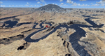
| Category: Flight Simulator 2004 - Scenery | |
| Torrey, Box-Death Hollow Wilderness, Aquarius Plateau, Utah, Photo-Scenery (FS9 & FSX) |

|
Images related to this file:
File Description:
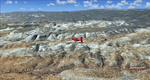
The southern part of this region covers the Box-Death Hollow Wilderness, with its vertical gray-orange walls of Navajo sandstone. Then comes the Aquarius Plateau which is the highest timbered plateau in North America with Boulder Mountain. In the north you'll find the little town of Torrey, which is just eight miles west of Capitol Reef National Park. Extends my Grand Staircase Escalante scenery to the north.
High resolution versions of this scenery for FS9 and FSX (much sharper, but larger and multiple downloads) are available at www.blueskyscenery.com/CNY_SouthWest3.html . The screenies are taken from the high-res versions, so expect this version to be slightly more blurry.
Thanks to Joop Mak for providing a custom AFCADs that correct airport layouts so that they align with the photo-textures! They are available here: www.blueskyscenery.com/AFCADs.html . YourDonation@Work: Dedicated to Ralf-Peter, Jon and Laurent.
| Filename: | Torrey_BoxDeath_Hollow_Wilderness_Aquarius_Plateau.zip |
| License: | Freeware, limited distribution |
| Added: | 3rd April 2010, 00:52:09 |
| Downloads: | 1,200 |
| Author: | Gottfried Razek - blueskyscenery.com |
| Size: | 93.79 MB |
| Category: Flight Simulator 2004 - Scenery | |
| Tucson, Arizona, High-Resolution Scenery - Part 1: Tucson Intl. Airport (KTUS) |
|
File Description:
This is the first part of high resolution ground scenery for Tucson AZ, containing Tucson Intl. airport (KTUS) and 90 sq km around it. The resolution of the airport area itself is 0.3m/pix! The area around is in 1m/pix resolution. Realistic real-world runway textures are provided as well. This scenery is best, when combined with my standard resolution Tucson scenery (TUS2008_LR.zip), which covers a much larger area and matches perfectly in color and everything. YourDonation@Work: Dedicated to Robert, George and Jeff. Thanks!
| Filename: | Tucson_Arizona_HighResolution_Scenery__Part_1_Tucs.zip |
| License: | Freeware, limited distribution |
| Added: | 10th September 2008, 23:58:16 |
| Downloads: | 4,259 |
| Author: | Gottfried Razek - www.blueskyscenery.com |
| Size: | 97.19 MB |
| Category: Flight Simulator 2004 - Scenery | |
| Sierra Nevada, California, Part 6: Sequoia National Park II (West) |
|
File Description:
This is the sixt part of BlueSky's Sierra Nevada project and the second part of Seqouia National Park. Connects seamlessly and extends the first part (Sequoia I) to the west. Completes the High Sierra packages and brings the total to 21.000 sq km covering three National Parks (Sequoia, Kings Canyon and Yosemite). Works equally well in FS2004 and FSX. YourDonation@Work: Dedicated to the donators Markus, Michael and Bernd. Thanks!
| Filename: | Sierra_Nevada_California_Part_6_Sequoia_National_P.zip |
| License: | Freeware, limited distribution |
| Added: | 3rd March 2008, 10:48:19 |
| Downloads: | 3,953 |
| Author: | Gottfried Razek (www.blueskyscenery.com) |
| Size: | 90.92 MB |
| Category: Flight Simulator 2004 - Scenery | |
| Buena Vista, Central Colorado Reg. (KAEJ form. 7V1), Colorado, Photo-Scenery (FS9 & FSX) |
|
Images related to this file:
File Description:
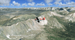
This region covers the area around Buena Vista and Central Colorado Reg. (KAEJ form. 7V1). It extends
my Leadville scenery to the south and brings you another 3.500 sq km of beautiful Colorado in 4.7m/pix quality. High resolution versions of this scenery for FS9 and FSX (much sharper, but larger and multiple downloads) are available at www.blueskyscenery.com/GNB_South3West.html . The screenies are taken from the high-res versions, so expect this version to be slightly more blurry. YourDonation@Work: Dedicated to Matias and Markus.
| Filename: | Buena_Vista_Central_Colorado_Reg_KAEJ_form_7V1_Col.zip |
| License: | Freeware, limited distribution |
| Added: | 7th February 2010, 11:31:14 |
| Downloads: | 1,574 |
| Author: | Gottfried Razek - blueskyscenery.com |
| Size: | 93.89 MB |
| Category: Flight Simulator 2004 - Scenery | |
| Mesa Verde National Park, Cortez (KCEZ), Colorado, Photo-Scenery (FS9 & FSX) |
|
Images related to this file:
File Description:
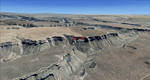
Mesa Verde National Park is famed for its numerous ruins of cliff dwellings built in the 12th century by ancient Pueblo people called Anasazi. Cliff dwellings are highly defensible stone villages situated under alcoves (rock overhangs) along the canyon walls. The largest cliff dwelling in the park is Cliff Palace, which is the largest cliff dwelling in North America. Cliff Palace contained 150 rooms and housed approximately 100 people. Unfortunately you won't see the cliff dwellings from the air, because they are under the cliffs but you will see everything else like all roads, trails and facilities. Very little is known about the Anasazis and the reason for their sudden departure at the end of the 13th century remains a mystery. Theories range from crop failures due to droughts to an intrusion of foreign tribes from the North. The name "Mesa Verde" stems from Spanish explorers seeking for a route from Sante Fe to California. They named the region Mesa Verde (spanish for green table) because of its high, tree-covered plateaus. High resolution versions of this scenery for FS9 and FSX (much sharper, but larger and multiple downloads)
are available at www.blueskyscenery.com/GNB_West2.html . The screenies are taken from the high-res versions, so expect this version to be slightly more blurry. Thanks to Joop Mak for providing custom AFCADs that correct airport layouts so that they align with the photo-textures! They are available at www.blueskyscenery.com/AFCADs.html . YourDonation@Work: Dedicated to David.
| Filename: | Mesa_Verde_National_Park_Cortez_KCEZ_Colorado_Phot.zip |
| License: | Freeware, limited distribution |
| Added: | 1st May 2010, 03:55:31 |
| Downloads: | 1,465 |
| Author: | Gottfried Razek - blueskyscenery.com |
| Size: | 92.87 MB |
| Category: Flight Simulator 2004 - Scenery | |
| Boulder (KBDU) / Longmont / Loveland, Colorado, Photo-Scenery (FS9 & FSX) |
|
Images related to this file:
File Description:

Boulder is situated where the Rocky Mountains meet the Great Plains. Just west of the city are imposing slabs of sedimentary stone tilted up on the foothills, known as Flatirons. Located at the base of the foothills is Boulder's main campus of the University of Colarado which is clearly visible from the sky. Longmont is home of the Denver ARTCC (Air Route Traffic Control Center) which controls all flights in the upper airspace of most of Colorado and parts of adjoining states. To explore the scenery depart from Boulder (KBDU) and head northeast. Extends my Rocky Mountain Park scenery to the east and my Denver scenery to the north. Provides another 3.500 sq km in 4.7m/pix quality. High resolution versions for FS9 and FSX (much sharper, but larger and multiple downloads) are available at www.blueskyscenery.com/GNB_East.html . The screenies are taken from the high-res versions, so expect this version to be slightly more blurry. YourDonation@Work: Dedicated to Senges and Eric.
| Filename: | Boulder_KBDU__Longmont__Loveland_Colorado_PhotoSce.zip |
| License: | Freeware, limited distribution |
| Added: | 28th December 2009, 20:14:09 |
| Downloads: | 2,384 |
| Author: | Gottfried Razek - blueskyscenery.com |
| Size: | 94.26 MB |
| Category: Flight Simulator 2004 - Scenery | |
| Eagle County (KEGE), Glenwood Springs (KGWS), Colorado, Photo-Scenery (FS9 & FSX) |
|
Images related to this file:
File Description:
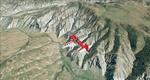
To explore this region depart from Eagle County Regional Airport (KEGE) which is a popular regional airport used in winter to transport skiers to nearby Vail. Northwest of the airport you can see the pit gypsum mine of American Gypsum which produces a variety of wallboard products. When you fly to the west and along the Eagle River, you soon pass its confluence with the Colorado River. Further west you can fly along Glennwood Canyon and finally reach Glennwood Springs where the Colorado meets the Roaring Fork River. Here you can turn south and fly direct Glenwood Springs Airport (KGWS) which lies south of the city. This scenery brings you another 3.500 sq km of beautiful Colorado in 4.7m/pix quality.
High resolution versions of this scenery for FS9 and FSX (much sharper, but larger and multiple downloads) are available at www.blueskyscenery.com/GNB_SouthWest2.html . The screenies are taken from the high-res versions, so expect this version to be slightly more blurry. YourDonation@Work: Dedicated to Alain and James.
| Filename: | Eagle_County_KEGE_Glenwood_Springs_KGWS_Colorado_P.zip |
| License: | Freeware, limited distribution |
| Added: | 30th January 2010, 17:01:49 |
| Downloads: | 2,705 |
| Author: | Gottfried Razek - blueskyscenery.com |
| Size: | 93.8 MB |
| Category: Flight Simulator 2004 - Scenery | |
| Monument Valley, Kayenta (0V7), Utah/Arizona, Photo-Scenery |
|
Images related to this file:
File Description:

Monument Valley, Kayenta (0V7), Utah/Arizona, Photo-Scenery (FS9 & FSX)
This scenery covers the area from south of the San Juan River down to wonderful Monument Valley and Kayenta, AZ.
It extends my Lake Powell sceneries to the south and brings you another
3.500 sq km in 4.7m/pix quality. To explore the scenery depart from Kayenta (0V7) and head north.
High resolution versions of this scenery for FS9 and FSX (much sharper, but larger and multiple downloads) are available at www.blueskyscenery.com/CNY_South3West.html . The screenies are taken from the high-res versions, so expect this version to be slightly more blurry. YourDonation@Work: Dedicated to Thomas, Don and Eric.
| Filename: | Monument_Valley_Kayenta_0V7_UtahArizona_PhotoScene.zip |
| License: | Freeware, limited distribution |
| Added: | 23rd January 2010, 10:45:32 |
| Downloads: | 2,282 |
| Author: | Gottfried Razek - blueskyscenery.com |
| Size: | 93.49 MB |
| Category: Flight Simulator 2004 - Scenery | |
| Lake Powell, Navajo Mountain (04UT), Utah/Arizona, Photo-Scenery (FS9 & FSX) |
|
Images related to this file:
File Description:
This package contains the center of Lake Powell and the Navajo Nation around Navajo Mountain. It contains remote areas of stunning beauty. Wonderful sandstone formations in bright shades of red and pink. Contains landmarks like the Rainbow Bridge National Monument and the confluence of the Colorado and San Juan Rivers. Extends my Monument Valley scenery to the west and brings you another 3.500 sq km in 4.7m/pix quality. To explore the scenery depart from Navajo Mountain dirt strip (04UT). High resolution versions of this scenery for FS9 and FSX (much sharper, but larger and multiple downloads) are available at www.blueskyscenery.com/CNY_South3West2.html . The screenies are taken from the high-res versions, so expect this version to be slightly more blurry. YourDonation@Work: Joaquin, Donald and Scott.
| Filename: | Lake_Powell_Navajo_Mountain_04UT_UtahArizona_Photo.zip |
| License: | Freeware, limited distribution |
| Added: | 23rd January 2010, 23:06:49 |
| Downloads: | 1,783 |
| Author: | Gottfried Razek - blueskyscenery.com |
| Size: | 91.43 MB |
| Category: Flight Simulator 2004 - Scenery | |
| Denver (KDEN), Colorado, Photo-Scenery |
|
Images related to this file:
File Description:

Denver (KDEN), Colorado, Photo-Scenery for FS9 & FSX.
This package covers Denver, the capital of Colorado which is also nicknamed Mile-High City because its elevation is one mile (5.280 ft). The sixth RW (16R/34L) of Denver Int'l. Airport (KDEN) is the longest commercial RW in the US with a length of 16.000ft. This allows fully loaded B747's to take off in Denvers mile-high altitude during hot summer days, when density altitudes can approach 9.000(!) ft.
KDEN is a major hub for United Airlines and the headquarters for Frontier Airlines. The airports distinctive white tent-like fabric roof is designed to be reminiscent of the snow-covered peaks of the Rocky Mountains which you can see on approach or departure.
Other important airports covered by this region are Centennial Airport (KAPA), Buckley AFB (KBKF) and Rocky Mountain Metropolitan Airport (KBJC). Extends my Mt.Evans/Georgetown package to the east and provides another 3.500 sq km in 4.7m/pix quality.
High resolution versions for FS9 and FSX (much sharper, but larger and multiple downloads) are available at www.blueskyscenery.com/GNB_SouthEast.html
. The screenies are taken from the high-res versions, so expect this version to be slightly more blurry. YourDonation@Work: Dedicated to Mark and Charles. Thanks!
| Filename: | Denver_KDEN_Colorado_PhotoScenery.zip |
| License: | Freeware, limited distribution |
| Added: | 31st October 2009, 11:24:39 |
| Downloads: | 7,274 |
| Author: | Gottfried Razek, blueskyscenery.com |
| Size: | 95.21 MB |
© 2001-2026 AVSIM Online
All Rights Reserved
Privacy Policy |