
Where Flight Simulation Enthusiasts Gather from Around the World!
AVSIM Library - Search Results

| Category: Flight Simulator 2004 - Scenery | |
| Santa Monica (SMO) High Resolution Airport Area Ground Scenery |

|
File Description:
This package contains high resolution ground scenery for the traffic pattern area of Santa Monica (SMO). Normal flight simulator scenery has a resolution of approximately 4.7 meters/pixel. That's OK at higher altitudes but leads to very blurry ground textures when flying low - e.g. in the traffic pattern. My high resolution airport area sceneries have a resolution 1.2 meters/pixel. This results in much more detail and a more realistic experience of "being there".
This scenery gives best results when combined with my "Southern-" and "Northern Los Angeles" standard resolution ground sceneries, available here:
Southern Los Angeles: http://library.avsim.net/esearch.php?CatID=fs2004scen&DLID=89921
Northern Los Angeles: http://library.avsim.net/esearch.php?CatID=fs2004scen&DLID=89911
For more information please visit: http://n330dg.batcave.net
| Filename: | Santa_Monica_SMO_High_Resolution_Airport_Area_Ground_Scenery.zip |
| License: | Freeware, limited distribution |
| Added: | 23rd August 2006, 22:08:43 |
| Downloads: | 7,973 |
| Author: | Gottfried Razek |
| Size: | 17.96 MB |
| Category: Flight Simulator 2004 - Scenery | |
| Southern Los Angeles, California |
|
File Description:
This scenery contains ground scenery for the area of southern Los Angeles, LAX, TOA, HHR, LGB in standard FS-resolution of 4.7m/pixel.
| Filename: | Southern_Los_Angeles_California.zip |
| License: | Shareware, honor system |
| Added: | 17th August 2006, 04:05:49 |
| Downloads: | 17,333 |
| Author: | Gottfried Razek |
| Size: | 21.87 MB |
| Category: Flight Simulator 2004 - Scenery | |
| San Francisco Int. (SFO) High Res Ground Scenery |
|
File Description:
This scenery contains high resolution ground scenery for the airport of San Francisco Intl. (SFO). It makes me kind of nostalgic, because that's the area where I first successfully tried my hi-res mesh technique for FS2004. The scenery has a resolution of 1.2m/pix (4.7m/pix is FS2004-standard). Coverage is the area around SFO containing the San Bruno Mountain Park and the San Adreas Res. So it's quiet a sight! And don't forget to bring some flowers :-) The scenery gives best results when combined with with my "San Francisco" standard resolution ground scenery, which covers a much larger area at 4.7m/pix and matches perfectly in color and everything...
Won't work in FSX. For FSX please wait for the upcoming FSX-version of this scenery.
| Filename: | San__Francisco_Int_SFO_High_Res_Ground_Scenery.zip |
| License: | Freeware, limited distribution |
| Added: | 27th November 2006, 10:58:19 |
| Downloads: | 16,816 |
| Author: | Gottfried Razek |
| Size: | 41.8 MB |
| Category: Flight Simulator X - Scenery | |
| Santa Barbara and Santa Ynez Scenery for use with Razek's Hi-res Photo Scenery |
|
File Description:
This scenery is designed to work with Gottfried Razek's great Santa Barbara Municipal (KSBA) and Santa Ynez Mts, California Hi-Res Photo-Scenery. The default structures at KSBA and KIZA airports are replaced by custom 3d objects and runways/taxiways adjusted to conform to the accurate photo scenery. Razek's sba2008_hr_fsx.zip and sba2008_lr.zip freeware photo scenery is required.
| Filename: | Santa_Barbara_and_Santa_Ynez_Scenery_for_use_with_.zip |
| License: | Freeware |
| Added: | 6th February 2009, 18:59:39 |
| Downloads: | 1,102 |
| Author: | Al Wheeler |
| Size: | 3.76 MB |
| Category: Flight Simulator 2004 - Scenery | |
| Colorado Springs South (KCOS), Colorado, Photo-Scenery |
|
Images related to this file:
File Description:
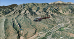
Colorado Springs South (KCOS), Colorado, Photo-Scenery (FS9 & FSX)
This region covers the area of Colorado Springs. Just west of the city you can fly around Pikes Peak. At 14.115ft it is the easternmost of Colorado's 54 fourteeners. Northwest of the city lies the Garden Of Gods with its many vertical rock formations. They are made of sedimentary beds red and white sandstones, conclomerates and limestone that were deposited horizontally but have been tilted vertically and faulted by the immense mountain building forces caused by the uplift of the Pikes Peak massiv. Deep within Chayenne Mountain is the North American Aerospace Defense Command's (NORAD) main technical facility which collects and evaluates data from a worldwide system of satellites, radars and other sensors.
High resolution versions of this scenery for FS9 and FSX (much sharper, but larger and multiple downloads) are available at www.blueskyscenery.com/GNB_South3East.html . The screenies are taken from the high-res versions, so expect this version to be slightly more blurry. YourDonation@Work: Dedicated to Veit and Hector.
| Filename: | Colorado_Springs_South_KCOS_Colorado_PhotoScenery.zip |
| License: | Freeware, limited distribution |
| Added: | 5th February 2010, 16:30:42 |
| Downloads: | 1,979 |
| Author: | Gottfried Razek, blueskyscenery.com |
| Size: | 95.63 MB |
| Category: Flight Simulator 2004 - Scenery | |
| St. George (KSGU) / Mesquite (67L), Utah/Nevada, Photo-Scenery (FS9 & FSX) |
|
Images related to this file:
File Description:
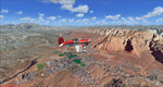
Covers the area between St. George, Utah and Mesquite, Nevada. To the north of St. George
the Pine Valley Mountains with their foothills of scenic red sandstone loom over the city.
St. George Municipal Airport (KSGU) is mostly used for general aviation but is also served by SkyWest Airlines
on behalf of Delta Connection. Because of it's location on a mesa this airport can't be expanded and so a new
airport is currently being built southeast of the city at the site of an abandoned airfield. The opening
is expected in 2011. To the south of the city make sure, you don't miss the Virgin River Gorge where the
Virgin River winds thru a long winding canyon in the transition zone between the red rocks of southern Utahs
Colorado Plateau and Nevadas Mojave Desert. Shortly afterwards you reach Mesquite which is situated just
west of the Arizona stateline. Like nearly all Nevada cities near the stateline Mesquite is home to several
Casinos. Mesquite Airport (67L) lies just north of the city.
High resolution versions of this scenery for FS9 and FSX (much sharper, but larger and multiple downloads)
are available at www.blueskyscenery.com/CNY_South3West6.html . The screenies are taken from the high-res versions,
so expect this version to be slightly more blurry. Thanks to Joop Mak for providing custom AFCADs that
correct airport layouts so that they align with the photo-textures! They are available at www.blueskyscenery.com/AFCADs.html .
YourDonation@Work: Dedicated to Werner, Ralf-Peter and Nels.
| Filename: | St_George_KSGU__Mesquite_67L_UtahNevada_PhotoScene.zip |
| License: | Freeware, limited distribution |
| Added: | 24th March 2010, 19:41:43 |
| Downloads: | 1,649 |
| Author: | Gottfried Razek - blueskyscenery.com |
| Size: | 95.58 MB |
| Category: Flight Simulator 2004 - Scenery | |
| Page (KPGA), Lake Powell West, Utah/Arizona, Photo-Scenery (FS9 & FSX) |
|
Images related to this file:
File Description:
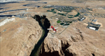
This scenery covers the western part of Lake Powell, the city of Page (KPGA), the Vermillion Cliffs, Glenn Canyon just south of Glenn Canyon Dam, the northern part of Marble Canyon, Paria Canyon, Cockscomb, etc, etc. Spectacular! To explore the scenery depart from Page Municipal Airport (KPGA). High resolution versions of this scenery for FS9 and FSX (much sharper, but larger and multiple downloads) are available at www.blueskyscenery.com/CNY_South3West3.html . The screenies are taken from the high-res versions, so expect this version to be slightly more blurry. YourDonation@Work: Dedicated to William, Veit and Michele.
| Filename: | Page_KPGA_Lake_Powell_West_UtahArizona_PhotoScener.zip |
| License: | Freeware, limited distribution |
| Added: | 3rd March 2010, 21:26:32 |
| Downloads: | 1,817 |
| Author: | Gottfried Razek - blueskyscenery.com |
| Size: | 92.41 MB |
| Category: Flight Simulator 2004 - Scenery | |
| Park County, Colorado, Photo-Scenery (FS9 & FSX) |
|
Images related to this file:
File Description:

Covers the gap between my Leadville and Colorado Springs North sceneries and provides you with continuous coverage for longer cross country flights. High resolution versions of this scenery for FS9 and FSX (much sharper, but larger and multiple downloads) are available at www.blueskyscenery.com/GNB_South2.html . The screenies are taken from the high-res versions, so expect this version to be slightly more blurry. YourDonation@Work: Dedicated to Arthur and Pierre-Alain.
| Filename: | Park_County_Colorado_PhotoScenery_FS9__FSX.zip |
| License: | Freeware, limited distribution |
| Added: | 3rd February 2010, 22:19:58 |
| Downloads: | 1,420 |
| Author: | Gottfried Razek - blueskyscenery.com |
| Size: | 89.49 MB |
| Category: Flight Simulator 2004 - Scenery | |
| Comb Ridge, Rock Point (49AZ), Utah/Arizona, Photo-Scenery |
|
Images related to this file:
File Description:

Comb Ridge, Rock Point (49AZ), Utah/Arizona, Photo-Scenery (FS9 & FSX)
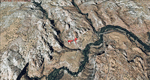
This scenery extends my Monument Valley scenery to the east. It covers the area between the San Juan River in the north down to Rock Point, AZ (49AZ). Most of the scenery lies on the Navajo Nation Reservation. It completes the southeastern corner of Utah and paves our way into Colorado.
High resolution versions of this scenery for FS9 and FSX (much sharper, but larger and multiple downloads) are available at www.blueskyscenery.com/CNY_South3West6.html . The screenies are taken from the high-res versions, so expect this version to be slightly more blurry. Thanks to Joop Mak for providing custom AFCADs that correct airport layouts so that they align with the photo-textures! They are available at www.blueskyscenery.com/AFCADs.html . YourDonation@Work: Dedicated to Olivier, Kevin and Ruben.
| Filename: | Comb_Ridge_Rock_Point_49AZ_UtahArizona_PhotoScener.zip |
| License: | Freeware, limited distribution |
| Added: | 9th April 2010, 21:57:41 |
| Downloads: | 1,355 |
| Author: | Gottfried Razek, blueskyscenery.com |
| Size: | 90.99 MB |
| Category: Flight Simulator 2004 - Scenery | |
| Grand Staircase Escalante National Monument/East, Escalante (1L7), Utah, Photo-Scenery (FS9 & FSX) |
|
Images related to this file:
File Description:
This scenery contains the eastern part of the Grand Staircase Escalante National Monument. It extends from the town of Escalante down south where it connects with the Page/Lake Powell scenery. Contains the upper part of wonderful Escalante Canyon. To explore the scenery depart from Escalante Airport (1L7). Thanks to Joop Mak for providing a custom AFCAD that corrects the airport layout so that it matches with the photo-textures! High resolution versions of this scenery for FS9 and FSX (much sharper, but larger and multiple downloads) are available at www.blueskyscenery.com/CNY_South2West3.html . The screenies are taken from the high-res versions, so expect this version to be slightly more blurry. YourDonation@Work: Dedicated to Jay, Donald and Franz
| Filename: | Grand_Staircase_Escalante_National_MonumentEast_Es.zip |
| License: | Freeware, limited distribution |
| Added: | 4th March 2010, 22:44:30 |
| Downloads: | 1,485 |
| Author: | Gottfried Razek - blueskyscenery.com |
| Size: | 96.2 MB |
© 2001-2026 AVSIM Online
All Rights Reserved
Privacy Policy |