
Where Flight Simulation Enthusiasts Gather from Around the World!
AVSIM Library - Search Results

| Category: Navigation and ATC - Navigation | |
| Point Barrow Sectional Chart Chunks |

|
File Description:
Sectional chart chunks made from the August 2009 Sectional charts at the original scale, formatted in the WGS84 lat/long geographic coordinate system for the FSMap, moving map application for flight simulation use. The chart chunks are the full sectional divided by 2 tiles (east/west) and converted to baseline 8bit tiffs with packbits compression applied. The images average 6,000x6,000 pixels at about 25mb each, also included is the FSMap fsm Calibration file for importing. No further calibration is needed, just import, save, and enjoy.
| Filename: | Point_Barrow_Sectional_Chart_Chunks.zip |
| License: | Freeware |
| Added: | 30th March 2010, 00:33:24 |
| Downloads: | 283 |
| Author: | David Myers |
| Size: | 16.09 MB |
| Category: Navigation and ATC - Navigation | |
| Whitehorse Sectional Chart Chunks |
|
File Description:
Sectional chart chunks made from the August 2009 Sectional charts at the original scale, formatted in the WGS84 lat/long geographic coordinate system for the FSMap, moving map application for flight simulation use. The chart chunks are the full sectional divided by 2 tiles (east/west) and converted to baseline 8bit tiffs with packbits compression applied. The images average 6,000x6,000 pixels at about 25mb each, also included is the FSMap fsm Calibration file for importing. No further calibration is needed, just import, save, and enjoy.
| Filename: | Whitehorse_Sectional_Chart_Chunks.zip |
| License: | Freeware |
| Added: | 30th March 2010, 00:34:06 |
| Downloads: | 357 |
| Author: | David Myers |
| Size: | 22.88 MB |
| Category: Navigation and ATC - Navigation | |
| Kodiak Sectional & Inset Chart |
|
File Description:
Sectional chart chunks made from the August 2009 Sectional charts at the original scale, formatted in the WGS84 lat/long geographic coordinate system for the FSMap, moving map application for flight simulation use. The chart chunks are the full sectional divided by 2 tiles (east/west) and converted to baseline 8bit tiffs with packbits compression applied. The images average 6,000x6,000 pixels at about 25mb each, also included is the FSMap fsm Calibration file for importing. No further calibration is needed, just import, save, and enjoy.
| Filename: | Kodiak_Sectional__Inset_Chart.zip |
| License: | Freeware |
| Added: | 30th March 2010, 00:34:29 |
| Downloads: | 410 |
| Author: | David Myers |
| Size: | 19.99 MB |
| Category: Navigation and ATC - Navigation | |
| Ketchikan Sectional & Inset Chart |
|
File Description:
Sectional chart chunks made from the August 2009 Sectional charts at the original scale, formatted in the WGS84 lat/long geographic coordinate system for the FSMap, moving map application for flight simulation use. The chart chunks are the full sectional divided by 2 tiles (east/west) and converted to baseline 8bit tiffs with packbits compression applied. The images average 6,000x6,000 pixels at about 25mb each, also included is the FSMap fsm Calibration file for importing. No further calibration is needed, just import, save, and enjoy.
| Filename: | Ketchikan_Sectional__Inset_Chart.zip |
| License: | Freeware |
| Added: | 30th March 2010, 00:35:00 |
| Downloads: | 401 |
| Author: | David Myers |
| Size: | 16.44 MB |
| Category: Navigation and ATC - Navigation | |
| Juneau Sectional & Inset Chart |
|
File Description:
Sectional chart chunks made from the August 2009 Sectional charts at the original scale, formatted in the WGS84 lat/long geographic coordinate system for the FSMap, moving map application for flight simulation use. The chart chunks are the full sectional divided by 2 tiles (east/west) and converted to baseline 8bit tiffs with packbits compression applied. The images average 6,000x6,000 pixels at about 25mb each, also included is the FSMap fsm Calibration file for importing. No further calibration is needed, just import, save, and enjoy.
| Filename: | Juneau_Sectional__Inset_Chart.zip |
| License: | Freeware |
| Added: | 30th March 2010, 00:35:23 |
| Downloads: | 423 |
| Author: | David Myers |
| Size: | 22.65 MB |
| Category: Navigation and ATC - Navigation | |
| Fairbanks Sectional & TAC |
|
File Description:
Sectional chart chunks made from the August 2009 Sectional charts at the original scale, formatted in the WGS84 lat/long geographic coordinate system for the FSMap, moving map application for flight simulation use. The chart chunks are the full sectional divided by 2 tiles (east/west) and converted to baseline 8bit tiffs with packbits compression applied. The images average 6,000x6,000 pixels at about 25mb each, also included is the FSMap fsm Calibration file for importing. No further calibration is needed, just import, save, and enjoy.
| Filename: | Fairbanks_Sectional__TAC.zip |
| License: | Freeware |
| Added: | 30th March 2010, 00:35:48 |
| Downloads: | 387 |
| Author: | David Myers |
| Size: | 31.39 MB |
| Category: Navigation and ATC - Navigation | |
| IFR EnRoute High Alt Charts for Aerosoft's FSMap |
|
Images related to this file:
File Description:
IFR enroute high altitude chart chunks from the late 2009 charts, formatted in the lat/long geographic coordinate system for FSMap moving map application for flight simulation use.
The images are customized for moving map display (see link), and included is a Legend in PDF format.
Coverage is the lower 48 H-series divided into 45 tiff tiles from a full mosaic and converted to baseline 8bit tiffs with packbits compression applied. Included is the FSMap fsm Calibration file for importing. No further calibration is needed, just import, save, and enjoy.
| Filename: | IFR_EnRoute_High_Alt_Charts_for_Aerosofts_FSMap.zip |
| License: | Freeware |
| Added: | 18th April 2010, 09:55:51 |
| Downloads: | 607 |
| Author: | David Myers |
| Size: | 31.5 MB |
| Category: Navigation and ATC - Navigation | |
| Hawaii Sectional, Inset & Extras |
|
File Description:
Sectional chart chunks made from the August 2009 Sectional charts at the original scale, formatted in the WGS84 lat/long geographic coordinate system for the FSMap, moving map application for flight simulation use. The chart chunks are the full sectional divided by 2 tiles (east/west) and converted to baseline 8bit tiffs with packbits compression applied. The images average 6,000x6,000 pixels at about 25mb each, also included is the FSMap fsm Calibration file for importing. No further calibration is needed, just import, save, and enjoy. **This zip also contains the Guam Saipan, American Samoa sectionals and five 250k insets for the lower 48 charts.
| Filename: | Hawaii_Sectional_Inset__Extras.zip |
| License: | Freeware |
| Added: | 30th March 2010, 00:36:16 |
| Downloads: | 621 |
| Author: | David Myers |
| Size: | 27.71 MB |
| Category: Navigation and ATC - Navigation | |
| Twin Cities Sectional Chart Chunks for Aerosoft's FSMap |
|
File Description:
Sectional chart chunks made from the August 2009 Sectional charts at the original scale, formatted in the WGS84 lat/long geographic coordinate system for the FSMap, moving map application for flight simulation use.
The chart chunks are the full sectional divided by 2 tiles (east/west) and converted from the geotiffs to baseline 8bit tiffs with packbit compression applied, not for size but for efficiency. The images are about 6,000x6,000 pixels at about 25mb each, also included is the FSMap fsm Calibration file for importing.
**Note: The files in this download are the largest of the split sectionals, 6,000x7,000 due to the Lake of the Woods region extending the northern border. These should work in the gauge just fine, having tested the full sectional area tiff that is 12,000x7,000 at 60mb in size in the gauge the only difference was that the zoom in was limited to 10nm with these larger images (see the notes in the zip file).
| Filename: | Twin_Cities_Sectional_Chart_Chunks_for_Aerosofts_F.zip |
| License: | Freeware |
| Added: | 19th March 2010, 01:17:18 |
| Downloads: | 334 |
| Author: | David Myers |
| Size: | 34.27 MB |
| Category: Navigation and ATC - Navigation | |
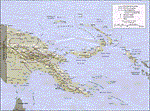
| Papua New Guinea Charts 2 of 3 |
|
Images related to this file:
File Description:
Calibrated for FSMap, but scanned images can be used in other map software, such as FSM Moving Map (FSMMM) by Rana Hossain. Chart source: Topographic Maps U.S. Army Map Service, Series T504, original scale 1:250,000, date 1964-. Courtesy of the University of Texas Libraries, The University of Texas at Austin. Missing: I could not find equivalent charts for New Britain; for this island, a lower-quality chart is included.
| Filename: | Papua_New_Guinea_Charts_2_of_3.zip |
| License: | Freeware |
| Added: | 7th May 2010, 10:45:02 |
| Downloads: | 795 |
| Author: | David Wilson-Okamura |
| Size: | 34.63 MB |
© 2001-2026 AVSIM Online
All Rights Reserved
Privacy Policy |