
Where Flight Simulation Enthusiasts Gather from Around the World!
AVSIM Library - Search Results

| Category: Flight Simulator 2004 - Scenery Design | |
| High detail Willys M151 JEEP With Lighs On |

|
File Description:
FS 2002/2004 High detail Willys M151 JEEP in *.api and *.scm formats, in three kinds of appearances with night lighs on.
Night texture included and very bright.
| Filename: | High_detail__Willys_M151_JEEP_With_Lighs_On.zip |
| License: | Freeware |
| Added: | 26th October 2003, 23:52:34 |
| Downloads: | 2,132 |
| Author: | Andrej Urosevic |
| Size: | 289.58 KB |
| Category: Flight Simulator X - Aircraft Repaints, Textures and Modifications | |
| Piper Cub (ZK-MPH) |
|
Images related to this file:
File Description:
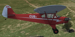
A repaint for the A2A Piper Cub in the colors of ZK-MPH, which was a Cuby Sport Trainer (Piper Replica), built by Darcy Hoffman in Dunedin and first registered on 29/4/82. It was sold to HCR Campion of Dunedin on 3/5/89 and to CT Keenan of Christchurch on 2/4/96. It was cancelled on the New Zealand register on 16/2/2000 when it was sold to the UK where it was re-registered as G-BZHU. It is still current in the UK. Repaint by Jan Kees Blom, based on the paintkit by A2A
| Filename: | Piper_Cub_ZKMPH.zip |
| License: | Freeware |
| Added: | 22nd November 2019, 17:57:04 |
| Downloads: | 94 |
| Author: | Jan Kees Blom |
| Size: | 8.25 MB |
| Category: Fly! II - TerraScene | |
| Maysville (Ohio Project) TerraScene Project Pack |
|
File Description:
This is a TerraScene 2.1 Project pack for southern Ohio and portions of northern Kentucky. It covers all of global tile 196,157 with Maysville, KY in the center. Above the Ohio River, you will find a portion of southern Ohio, with rolling hills and small towns, extending from Portsmouth, OH in the east to just below Cincinnati in the west. This pack includes updated Tiger Census (2000) shapefile data, adding new water areas, new highways, and other details. All scenery data files are included: USGS data, shapefiles, and a complete water mask. Requires TerraScene 2.1 and Fly!II patched to v230 or later.
| Filename: | Maysville_Ohio_Project_TerraScene_Project_Pack.zip |
| License: | Freeware |
| Added: | 4th May 2003, 14:51:31 |
| Downloads: | 174 |
| Author: | Randall Rocke |
| Size: | 61.6 MB |
| Category: Fly! II - TerraScene | |
| Van Wert (Ohio Project) TerraScene Project Pack |
|
File Description:
This is a TerraScene 2.1 Project pack for a narrow piece of NW Ohio and a portion of NE Indiana. It covers all of global tile 195,159 with Van Wert, Ohio situated in the eastern portion. To the west is the city of Fort Wayne, IN - to the SW are Muncie and Anderson, IN. This pack includes updated Tiger Census (2000) shapefile data, adding new water areas, new highways, and other details. All scenery data files are included: USGS data, shapefiles, and a complete water mask. Requires TerraScene 2.1 and Fly!II patched to v230 or later.
| Filename: | Van_Wert_Ohio_Project_TerraScene_Project_Pack.zip |
| License: | Freeware |
| Added: | 11th May 2003, 02:18:46 |
| Downloads: | 144 |
| Author: | Randall Rocke |
| Size: | 27.7 MB |
| Category: Flight Simulator X - Aircraft Repaints, Textures and Modifications | |
| FSX Aircraft - Beechcraft Starship Update |
|
File Description:
FSX Aircraft-The Beechcraft Starship version 5.1. Beech was looking for a new generation of corporate transports. They looked to Burt Rutan's Scaled Composites Inc. to design and produce the SCAT1, an 85% scale technology demonstrator of a conard-configured aircraft. Successing in testing led to the Model 2000 Starship 1. The first of 3 flying pre-production Starship 1s flew on Feburary 15, 1986. After flying and statice tests, the first production machine flew on April 25, 1989. Created with FSDS 2.10. This model features reflective textures. This FS9 model has been modified to work in FSX. By John B. Loney, Jr.
| Filename: | FSX_Aircraft__Beechcraft_Starship_Update.zip |
| License: | Freeware |
| Added: | 5th November 2006, 20:30:46 |
| Downloads: | 985 |
| Author: | John B. Loney, Jr. |
| Size: | 3.19 MB |
| Category: Flight Simulator X - Scenery | |
| West Virginia Float Plane Repair Station |
|
File Description:
This is a fictitious float plane repair station located in West Virginia on an island on the Ohio River. With no legal hard surface runways this scenery is designed for Float Planes and has ramps to accommodate Amphibious aircraft. **HOWEVER**, some of the roads around the hangers have been used for landing when no one was watching. This particular Float Repair Station had a dirt road of which over 2000 feet is suitable for landing light planes. There have been DC-3's landing on that road with no problems but CAUTION.... Make sure you do NOT land short.
| Filename: | West_Virginia_Float_Plane_Repair_Station.zip |
| License: | Freeware |
| Added: | 16th February 2008, 09:39:14 |
| Downloads: | 967 |
| Author: | Bob Smith |
| Size: | 1.19 MB |
| Category: Flight Simulator 2004 - AI Flight Plans | |
| Polet Air Company (Russia) Winter 2007/2008 |
|
File Description:
Initial started as a cargo carrier (inter alia operating An-124 aircraft) since August 2003 Polet Airlines Company (Polyot Rossiskaya aviakompania) has started regular passenger operations between several Russian cities on Yak-40 and An-24 aircraft. Currently - operating Saab 2000 and An-24 aicraft - passenger service network include Moscow, St.Petersburg, Voronezh, Tambov, Belgorod and Ulyanovsk on domestic scheduled flights. International flights are operated to Munich, Prague, Istanbul, Yerevan and Baku. Data taken from Polets web site. Schedule effective 28th October 2007 to 29th March 2008. Tested with TTools - bgl-file included. Cargo flight not included.
| Filename: | Polet_Air_Company_Russia_Winter_20072008.zip |
| License: | Freeware |
| Added: | 2nd January 2008, 22:35:25 |
| Downloads: | 1,205 |
| Author: | Uwe Hoffmann |
| Size: | 13.14 KB |
| Category: Fly! II - TerraScene | |
| Ashtabula (Ohio Project) TerraScene Project Pack |
|
File Description:
This is a TerraScene 2.1 Project pack for northeastern Ohio. It covers all of global tile 198,160 with Ashtabula in the NE. It extends from Cleveland/Cuyahoga in the NW to Youngstown in the SE and from Erie, PA in the NE to Ravenna in the SSW. The far eastern edge extends through Meadville, PA. This pack includes updated Tiger Census (2000) shapefile data, adding new water areas, new highways, and other details. All scenery data files are included: USGS data, shapefiles, and a complete water mask. Requires TerraScene 2.1 and Fly!II patched to v230 or later.
| Filename: | Ashtabula_Ohio_Project_TerraScene_Project_Pack.zip |
| License: | Freeware |
| Added: | 26th May 2010, 00:57:56 |
| Downloads: | 416 |
| Author: | Randall Rocke |
| Size: | 59.19 MB |
| Category: Fly! II - TerraScene | |
| Hilton Head (Carolinas Project) TerraScene Project Pack |
|
Images related to this file:
File Description:
Re-upload. This TerraScene 2.1 Project pack covers all of global tile 198,152, extending the coastline from Charleston to the northern portion of Savannah, GA. Along the coast you will find such beautiful areas as Pritchards Island, Beaufort, and the famous Hilton Head Island. To the north is Walterboro, SC. The Savannah area includes Savannah International Airport. This pack includes updated Tiger Census (2000) shapefile data, adding new water areas, new highways, and other details. All scenery data files are included: USGS data, shapefiles, and a complete custom water mask. Requires TerraScene 2.1 and Fly!II patched to v230 or later.
| Filename: | Hilton_Head_Carolinas_Project_TerraScene_Project_P.zip |
| License: | Freeware |
| Added: | 27th May 2010, 03:02:58 |
| Downloads: | 185 |
| Author: | Randall Rocke |
| Size: | 55.06 MB |
| Category: Flight Simulator 2004 - Scenery | |
| Project Mexico Real LOD10 File 1 of 11 |
|
Images related to this file:
File Description:
File 1st of 11 of a Terrain Mesh that covers the entirety of Mexican Territory and related bordering U.S., Guatemala and Belice areas, part of the "Proyecto Mexico Real" project, compiled at LOD10 (1.24 arcseconds in latitude and 1.65 arcseconds in longitude) resolution from INEGI data. Intended to enhance the virtual flying experience complementing the LOD8 and LOD9 versions compiled from the same data. Compatible backwards with Flight Simulator 2000, Flight Simulator 2002 and Combat Flight Simulator 2. Refer to the file contents about the cover area to this compressed file. (Re-upload due to AVSIM hack)
| Filename: | Project_Mexico_Real_LOD10_File_1_of_11.zip |
| License: | Check within download |
| Added: | 6th June 2010, 09:05:59 |
| Downloads: | 4,162 |
| Author: | Juan Jose Galvan Bautista |
| Size: | 73.44 MB |


© 2001-2026 AVSIM Online
All Rights Reserved
Privacy Policy |