
Where Flight Simulation Enthusiasts Gather from Around the World!
AVSIM Library - Search Results

| Category: Flight Simulator 2004 - AFCAD Files | |
| LLMG Meggido, Israel |

|
Images related to this file:
File Description:
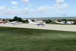
Googlyafcad A&F Data for Meggido, based on Google Earth satellite data.
Unfortunately, Microsoft have provided no facilities at this airport in Flight Simulator 2004 other than a runway and this file will allow you and your "AI" traffic to land, taxi, park and take off in a realistic manner.
Meggidio airfield was built in 1942 by the British Forces and was used by the Israeli Air Force (under the name Shachar 7) until turned over to general aviation, gliding and crop spraying use in the 1970s. There are proposals to transform it into a commercial airport with international flights to develop tourism. [File re-uploaded at request of AVSIM]
| Filename: | af2_llmg.zip |
| License: | Freeware |
| Added: | 20th June 2010, 10:49:59 |
| Downloads: | 495 |
| Author: | John Hinson |
| Size: | 47 KB |
| Category: Flight Simulator 2004 - AFCAD Files | |
| WAOI/WRBI Pangkalanbun/Iskandar, Indonesia |
|
Images related to this file:
File Description:
Googlyafcad A&F Data file for Iskandar, based on Google Earth satellite data. Iskandar is a small domestic airport in Pangkalanbun, on Borneo, Indonesia. Unfortunately, Microsoft have provided no facilities in Flight Simulator 2004 at this airport, which is served by a few flights a day operated by small airlines like Deraya Air Taxi and Indonesia Air Taxi. These files will allow you and your "AI" traffic to land, taxi, park and take off in a realistic manner.
Like many airports in Indonesia, the ICAO code has changed in recent years. Microsoft Flight Simulator 2004 uses the old code (WRBI) and these files allow you to continue using that code or change to the new one. [File re-uploaded at request of AVSIM]
| Filename: | af2_waoi.zip |
| License: | Freeware |
| Added: | 20th June 2010, 10:52:36 |
| Downloads: | 499 |
| Author: | John Hinson |
| Size: | 62 KB |
| Category: Flight Simulator 2004 - AFCAD Files | |
| Asheville Regional Airport |
|
Images related to this file:
File Description:
Asheville, NC airport upgrade from stock airport using satellite imaging.
| Filename: | avl.zip |
| License: | Freeware |
| Added: | 13th September 2010, 01:08:54 |
| Downloads: | 311 |
| Author: | David Hinson |
| Size: | 15 KB |
| Category: Flight Simulator 2004 - Scenery | |
| PAIW Wales, Alaska, USA |
|
Images related to this file:
File Description:
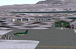
Googly scenery for Wales - a small domestic airport on the western coast of Alaska that is poorly provided for in Flight Simulator 2004. These scenery files add taxiways, aprons, buildings and other airport features, so that you and your "AI" traffic can land, taxi, park and take off in a realistic manner.
Wales is a small village with a population of just over 150 people, so the facilities at this 4000 foot gravel airstrip are fairly limited. The airport is allocated the ICAO code PAIW, although Microsoft has ignored this in Flight Simulator and uses the IATA ticket code IWK. Wales is served by light aircraft from airlines such as Bering Air, Cape Smythe Air, Frontier Flying Service, and Hageland Aviation Services. You might find it a convenient stopping-off point for a quick trip across to Russia - this is about as close as you can get and a nip across the Bering Strait will find you there in no time.
The scenery does not purport to be ultra-accurate. Based on high-detail satellite imagery from Google Earth, the layout is proportionally correct but the added airport features, such as buildings, are built from default Microsoft objects and add-on libraries so will not look like the real thing.
You are not obliged to download and install any additional scenery libraries, but to enjoy this scenery in its entirety, you may wish to. It will work fine, with or without.
[File re-uploaded at request of AVSIM]
| Filename: | paiw.zip |
| License: | Freeware |
| Added: | 26th June 2010, 13:51:45 |
| Downloads: | 1,256 |
| Author: | John Hinson |
| Size: | 77 KB |
| Category: Flight Simulator 2004 - Scenery | |
| LTBM Isparta, Turkey |
|
Images related to this file:
File Description:
Googly scenery for LTBM Isparta, Turkey - a small airport for which nothing more than a runway has been provided in Flight Simulator 2004. These scenery files add the apron, taxiways, buildings and other airport features so that you and your "AI" traffic can land, taxi, park and take off in a realistic manner.
The airport appears to used mainly for occasional tourism flights, particularly traffic to and from Iran.
The scenery does not purport to be ultra-accurate. Based on high-detail satellite imagery from Google Earth, the layout is proportionally correct but the added airport features, such as buildings, are built from default Microsoft objects and add-on libraries so will not look like the real thing.
You are not obliged to download and install any additional scenery libraries, but to enjoy this scenery in its entirety, you may wish to. It will work fine, with or without.
[File re-uploaded at request of AVSIM]
| Filename: | ltbm.zip |
| License: | Freeware |
| Added: | 26th June 2010, 13:53:59 |
| Downloads: | 1,557 |
| Author: | John Hinson |
| Size: | 88 KB |
| Category: Flight Simulator 2004 - AFCAD Files | |
| PAYA Yakutat, Alaska, USA |
|
File Description:
Googlyafcad A&F Data for Yakutat, based on Google Earth satellite data.
Unfortunately, Microsoft have only limited facilities at this airport in Flight
Simulator 2004 with no provision for commercial traffic and this file will allow
you and your "AI" traffic to land, taxi, park and take off in a realistic manner.
Yakutat airport sees regular flights by Boeing 737 jets of Alaska Airlines, along
with smaller-sized traffic by local operators such as Arctic Circle Air Service
| Filename: | af2_paya.zip |
| License: | Freeware |
| Added: | 5th August 2008, 08:29:27 |
| Downloads: | 523 |
| Author: | John Hinson |
| Size: | 63 KB |
| Category: Flight Simulator 2004 - AFCAD Files | |
| FS2004 A&F DATA |
|
File Description:
Googlyafcad A&F Data for Angouleme/Brie/Champniers, based on Google Earth satellite
data.
Unfortunately, Microsoft have only limited facilities at this airport in Flight
Simulator 2004 with no provision for commercial traffic and this file will allow
you and your "AI" traffic to land, taxi, park and take off in a realistic manner.
Whilst the airport is primarily used by General Aviation traffic, it now sees regular
flights by Boeing 737 jets of Ryanair.
| Filename: | afx_lfbu.zip |
| License: | Freeware |
| Added: | 5th August 2008, 13:39:58 |
| Downloads: | 375 |
| Author: | John Hinson |
| Size: | 49 KB |
| Category: Flight Simulator 2004 - AFCAD Files | |
| SBCZ Cruzeiro Do Sul International, Brazil |
|
File Description:
Googlyafcad A&F Data for Cruzeiro Do Sul International (Aeroporto Internacional
de Cruzeiro do Sul), a small commercial airport serving the town of the same
name in Brazil's Acre state, not far from the border with Peru. The primary
business in this area is rubber, but additionally coffee, rice and cassava are
farmed.
Unfortunately, Microsoft have provided only general aviation facilities at this
airport, which sees daily flights by Boeing jets of GOL Transportes Aereos. This
file will allow you and your "AI" traffic to land, taxi, park and take off in a
realistic manner.
| Filename: | afx_sbcz.zip |
| License: | Freeware |
| Added: | 20th September 2008, 13:21:08 |
| Downloads: | 1,099 |
| Author: | John Hinson |
| Size: | 48 KB |
| Category: Flight Simulator 2004 - Scenery | |
| SKMD Medellin/Enrique Olaya Herrera, Colombia |
|
File Description:
Googly scenery for Medellin/Enrique Olaya Herrera (ICAO: SKMD, IATA: EOH). This
centrally located airport, named after the 1930 president of Colombia, was once
the only airport for the city of Medellin but most international flights are now
concentrated on the new international airport inconveniently situated 24 miles
away. Nevertheless the airport is very busy with domestic, charter and private
traffic and is regularly served by scheduled services of Aerolínea de Antioquia,
AIRES, Easyfly and SATENA. There are many charter operators based or serving
serving this airport, including Aexpa, Heliandes, Sarpa, Helicol and TAC; these
are mostly smaller aircraft or helicopter operations.
Remarkably for such an important airport, Microsoft have only provided a runway
at this airport in Flight Simulator 2004 and this scenery seeks to redress the
situation so that you and your "AI" traffic can use the airport realistically.
The scenery does not purport to be ultra-accurate. Based on high quality
satellite imagery from Google Earth, the layout is proportionally correct but the
added airport features, such as buildings, are built from default Microsoft objects
and add-on libraries so will not look exactly like the real thing.
You are not obliged to download and install any additional scenery libraries,
but to enjoy this scenery in its entirety, you may wish to. It will work fine,
with or without.
| Filename: | skmd.zip |
| License: | Freeware |
| Added: | 6th December 2008, 10:22:40 |
| Downloads: | 2,538 |
| Author: | John Hinson |
| Size: | 388 KB |
| Category: Flight Simulator 2004 - Sounds | |
| ATC Voices -Airport names set 15 |
|
File Description:
A collection of 38 additional, improved or corrected airport names, for
use with Flight Simulator 2004 and FS2002. Installation requires the
EditVoicepack software (see
http://bevelstone.xs4all.nl/FlightSimulator/EditVoicepack) by Lars
Møllebjerg which is also available as a free download from the usual
Flight Simulator download sites such as Avsim.
The airports represented here are:
2F0 Iraan Mun (USA),
69R Rock Springs/Edwards Co (USA),
CCD3 Woodstock (Canada),
CYGW Kuujjuarapik (Canada),
CYPX Puvirnituq (Canada),
EFKG Kumlinge (Finland),
EGEO Oban/North Connel (UK),
OKAJ Ahmed Al Jaber AB (Kuwait),
OP0X Khanpur (Pakistan),
ORBI Baghdad Intl (Iraq),
OS0G Marj Ruhayyil (Syria),
SBCZ Cruzeiro Do Sul-Intl (Brazil),
SKLA Malaga (Columbia),
SMPA Paloemeu/Vincent Faiks (Surinam),
TE33 Midland/Eagles Nest (USA),
UDYZ Yerevan/Zvartnots (Armenia),
ULPP Petrozavodsk/Peski (Russia),
URMG Grozny (Russia),
USHN Nyagan (Russia),
WAKT Tanah Merah (Indonesia),
X4DR Driffield (UK),
YCBP Coober Pedy (Australia) - improved,
YKKG Kalkgurung (Australia), and
ZSLG Lianyungang (China), plus locations
OBAN RADIO (UK) and
POVUNGNITUK (Canada).
| Filename: | vp-ap15.zip |
| License: | Freeware |
| Added: | 10th December 2008, 08:10:47 |
| Downloads: | 1,596 |
| Author: | John Hinson |
| Size: | 27 KB |
© 2001-2025 AVSIM Online
All Rights Reserved