
Where Flight Simulation Enthusiasts Gather from Around the World!
AVSIM Library - Search Results

| Category: Flight Simulator X - Scenery | |
| California Central Coast Scenery Complete |

|
File Description:
This is a compilation of CCCFSX.ZIP released on 4/25/08 plus all the subsequent revisions (1 through 4). If you've already installed CCCFSX.ZIP and it's 4 revisions, you don't need this file. This scenery covers the California Central Coast from Paso Robles in the North to Santa Barbara in the South with about 22 points of interest.
| Filename: | California_Central_Coast_Scenery_Complete.zip |
| License: | Freeware |
| Added: | 20th December 2008, 17:46:21 |
| Downloads: | 2,365 |
| Author: | Al Wheeler |
| Size: | 6.06 MB |
| Category: Flight Simulator X - Scenery | |
| California Central Coast with Megascenery Earth and FSGenesis Mesh |
|
Images related to this file:
File Description:
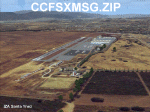
California Central Coast Scenery for FSX with Megascenery Earth and FSGenesis mesh. CCFSXMSG.ZIP covers the California coastal region from N36° 10' (Coalinga) to N34° 25' (Santa Barbara) and from the coast East to W119° 40'. It is a version of my previously created California Central Coast scenery redesigned and expanded to work with FSX MegaScenery Earth and FSGenesis USA Terrain Mesh for FSX V2 by Justin Tyme. Airstrips in the area covered by this scenery have been added for a total of 27 airports and airstrips. 6 imaginary water runways are also added for AI float plane traffic. Several other areas of interest such as the Santa Barbara marina, Morro Bay, etc. are included for a total of 41 points of interest. All airports, airstrips and related structures have been adjusted and realigned to conform to actual positions and dimensions as indicated by the MegaScenery Earth satellite textures. Megascenery Earth California-13, -14 and -15 are required and -12, -28 and -29 are recommended. By Al Wheeler 9/25/09.
| Filename: | California_Central_Coast_with_Megascenery_Earth_an.zip |
| License: | Freeware |
| Added: | 7th January 2010, 19:54:57 |
| Downloads: | 870 |
| Author: | Al Wheeler |
| Size: | 8.13 MB |
| Category: Flight Simulator X - Scenery | |
| California Central Coast Scenery for FSX with Megascenery Earth (Default Mesh Terrain) |
|
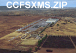
Images related to this file:
File Description:
Revised 1/7/10 for upload to Avsim.COM. CCFSXMSFix is incorporated so not required.
This is an earlier version of CCC Megascenery Earth scenery that doesn't require FSGenesis Mesh Terrain. See CCFSXMSG.ZIP for the FSGenesis Mesh version.
This scenery covers the California coastal region from N36���°10' (Coalinga) to N34���°25' (Santa Barbara) and from the coast East to W119���°40'. It is a version of my previous California Central Coast scenery redesigned and expanded to work with MegaScenery Earth from PC Aviator Inc. Many airstrips in the area covered by this scenery have been added or enhanced for a total of 27 airports/airstrips in the area. Several areas of interest such as the Santa Barbara marina, Morro Bay, etc. are also included for a total of 41 points of interest. All airports/airstrips and related structures have been adjusted and realigned to conform to actual positions and dimensions as indicated by the MegaScenery satellite textures. In addition, there are 6 invisible water runways for use by AI floatplane traffic. MegaScenery California-13, -14 and -15 are required for this scenery to make sense. I also used California-12, -28 and -29 when constructing the scenery but they could be considered optional.
| Filename: | California_Central_Coast_Scenery_for_FSX_with_Mega.zip |
| License: | Freeware |
| Added: | 7th January 2010, 21:28:45 |
| Downloads: | 1,559 |
| Author: | Al Wheeler |
| Size: | 8.12 MB |
| Category: Flight Simulator X - Scenery | |
| Crosswind Runways for California Central Coast Scenery for FSX with CCFSXMSG.ZIP or CCFSXMS.ZIP Installed |
|
Images related to this file:
File Description:
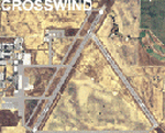
This scenery contains several revised files for my previously uploaded California Central Coast sceneries CCFSXMSG.ZIP and CCFSXMS.ZIP. These are the versions of my CCC scenery for FSX with MegaScenery Earth. The "G" version also requires Genesis Terrain Mesh but is the most complete version. Included here are revised AFCAD files for the major airports in those sceneries which will add interesting crosswind capability to C80, PRB, SBP, SMX and SBA airports. Additionaly, revised AFCAD and associated files for IZA, LPC, L52 and VBG are included. In some cases ground traffic has been added, a few glitches repaired and minor improvements effected. The crosswind AFCAD's for the 5 airports with tangential or crossing runways were revised using the technique developed by Jim Vile and executed by Airport Design Editor (ADEX). This procedure will unavoidably bolix up the ATIS runway advisories at the 3 tower controlled airports with ATIS (SBA, SBP and SMX) but will make all of the runways useable for AI traffic depending on wind conditions. This is not a problem at C80 and PRB since they are uncontrolled fields and have no ATIS available. Therefore, I've included revised AFCADs for SBA, SBP and SMX that do not have crosswind provisions that can be substituted if desired.
| Filename: | Crosswind_Runways_for_California_Central_Coast_Sce.zip |
| License: | Freeware |
| Added: | 7th January 2010, 22:05:25 |
| Downloads: | 514 |
| Author: | Al Wheeler |
| Size: | 194.42 KB |
| Category: Flight Simulator X - Miscellaneous Files | |
| 737-200 JT8D-15AH Performance Tables |
|
File Description:
737-200 JT8D-15AH Performance Tables from Aviacsa Airlines (2005)
| Filename: | 737200_JT8D15AH_Performance_Tables.zip |
| License: | Freeware |
| Added: | 14th December 2012, 09:44:27 |
| Downloads: | 291 |
| Author: | Al Stiff |
| Size: | 5.74 MB |
| Category: Flight Simulator X - Scenery | |
| SeaTac Airport Scenery Improvements |
|
File Description:
SEAFSX is an improvement to the default Seattle-Tacoma WA (SeaTac) airport that includes the new 3rd runway. The artificial plateau that the airport is built on has
been expanded, the 3rd runway added, several objects added, relocated or removed and
appropriate ground textures and landclass for the airport and immediate area added.
By Al Wheeler 12/19/08
| Filename: | SeaTac_Airport_Scenery_Improvements.zip |
| License: | Freeware |
| Added: | 19th December 2008, 17:59:52 |
| Downloads: | 3,368 |
| Author: | Al Wheeler |
| Size: | 457.93 KB |
| Category: Flight Simulator 2004 - Scenery | |
| California Central Coast Scenery with Ultimate Terrain USA |
|
File Description:
This is a complete revision to California Central Coast Scenery CCCOASTU.ZIP that was uploaded 9/13/05. This revision involves most of the files and replaces CCCOASTU.ZIP in it's entirety so the original version of CCCOASTU and it's Revisions 1 and 2 or any other versions of my CCC scenery are NOT required.
The primary goal for this revision was to replace as many API objects and effects as possible with XML/MDL library objects. The original intent for making these conversions was to begin to prepare for the FSX version of CCC scenery if that becomes practical. Because I also made several improvements and fixes during that process and because performance was improved due to use of object libraries I realized it might be appropriate to upload the results as a revision.
| Filename: | California_Central_Coast_Scenery_with_Ultimate_Ter.zip |
| License: | Freeware |
| Added: | 19th April 2006, 04:31:54 |
| Downloads: | 4,896 |
| Author: | Al Wheeler |
| Size: | 5.96 MB |
| Category: Flight Simulator X - Scenery | |
| California North Central Coast |
|
Images related to this file:
File Description:
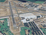
This is an expansion of my previously released CCFSXMSG scenery that covered 27 airports/airstrips within the confines of MegaScenery Earth California 012, 013, 014, 015, 028 and 029. CCNFSXMSG adds 20 more airstrips/airports North of those regions within the confines of MegaScenery Earth California 010, 011, 026 and 027. This addition covers roughly from N37 16' (Gustine) down to N36 10' (King City) and from the coast East to W120 42'/120 28'. CCFSXMSG.ZIP must have been installed for this scenery addition to work since many textures, etc. are shared.
| Filename: | California_North_Central_Coast.zip |
| License: | Freeware |
| Added: | 17th September 2010, 23:38:03 |
| Downloads: | 1,102 |
| Author: | Al Wheeler |
| Size: | 1.31 MB |
| Category: Microsoft Flight Simulator (2020) - Utilities | |
| Kneeboard Viewer 10 |
|
File Description:
Kneeboard Viewer 10 (KV10) allows the user to open one to ten ‘on-top-windows’ to view programs of choice, such as a web page like SkyVector, or pdf reader, or LittleNavmap, etc., in ‘kneeboard windows’ on top of FSX/P3D/X-Plane/MSFS while flying. The kneeboard windows will stay visible on top of FSX/P3D/X-Plane/MSFS (or most any other application) or may be toggled on and off (shown or hidden) by user selectable keys (or key combinations). A multi-window option allows multiple windows to be controlled by a single key. KV10 works in window or full screen mode. Download includes a KV10 Manual.
Program Installation
Unzip the KV10 zip file and put KV10.exe and the KV10Settings.ini file in the SAME directory. You can then pin KV10.exe to the task bar or send a shortcut to the desktop for easy start up access.
| Filename: | Kneeboard_Viewer_10.zip |
| License: | Freeware |
| Added: | 9th March 2021, 05:29:48 |
| Downloads: | 352 |
| Author: | Al Klayton |
| Size: | 831.04 KB |
| Category: Flight Simulator X - Utilities | |
| HUD Parameters for FSX |
|
Images related to this file:
File Description:
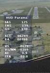
HUD_Parameters.lua is a Lua script that displays flight parameters in a small text window that pops up when the script is selected by an assigned key or button if the aircraft is in the air.
Parameters displayed are:
• Indicated Airspeed (IAS. Kts)
• True Airspeed (TAS, Kts)
• Ground Speed (GS, Kts)
• Mach# (when above a user settable altitude, currently 25000ft)
• Altitude (ALT, ft)
• Radio Altitude (RA, ft)
• Vertical Speed (VS, ft/min)
• Vertical Speed per Nautical Mile (VS/NM, ft/NM)
• Attitude Indicator pitch (AI, degrees)
• Flight Path Angle (FPA, degrees)
The top of the script contains user settable values for the size and location of the display, the altitude above which the a/c Mach# will be displayed (default is 25000ft), the data update interval in milliseconds (default is 2000),
and whether or not data is to be logged in HUD_Parameters.log (default is 0, off). These values can be set using a text editor like NotePad.
A registered copy of FSUIPC is required to execute the Lua script. Simply copy the script to the Modules folder of FSX and use FSUIPC4 to assign a key, button or switch to toggle the script on and off.
The script turns off if the aircraft is on the ground.
Al Klayton
| Filename: | HUD_Parameters_for_FSX.zip |
| License: | Freeware |
| Added: | 29th July 2017, 07:15:25 |
| Downloads: | 473 |
| Author: | Al Klayton |
| Size: | 16.82 KB |
© 2001-2026 AVSIM Online
All Rights Reserved
Privacy Policy |