
Where Flight Simulation Enthusiasts Gather from Around the World!
AVSIM Library - Search Results

| Category: Flight Simulator 2004 - Scenery | |
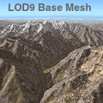
| Himalayas LOD9 Base Mesh, Volume 4 - Kashmir and Jammu |

|
File Description:
Detailed terrain mesh of the Kashmir and Jammu Ranges, N30-39 E76-78. The files in this package are based on Shuttle Radar (SRTM) Version 2 data but with many of the void areas, especially the most significant sections, filled with elevation data generated from topographic maps by Jonathan de Ferranti. While Jonathan's work is unrelated to flight simulation he kindly gave me permission to compile his data for use in FS. The result is a wonderful improvement in detail and accuracy over any existing mesh file, freeware or commercial, based on SRTM or DTED data alone.
Due to the large area of the Himalayas I've compiled the source data as two separate series: the "Himalayan Peaks" series covers prominent mountains and ranges in higher detail and locally overrides any existing LOD9 terrain mesh. In addition, the LOD9 "base mesh" series, with LOD8 and LOD7 "buffer" mesh files, covering the entire Himalayas, is meant for those who do not yet have an add-on terrain mesh of these beautiful mountains.
| Filename: | Himalayas_LOD9_Base_Mesh_Volume_4__Kashmir_and_Jam.zip |
| License: | Freeware, limited distribution |
| Added: | 22nd February 2006, 20:32:50 |
| Downloads: | 7,503 |
| Author: | Holger Sandmann, Jonathan de Ferranti |
| Size: | 29.24 MB |
| Category: Flight Simulator 2004 - Scenery | |
| Himalayas LOD9 Base Mesh, Volume 3 - Southwestern Ranges |
|
Images related to this file:
File Description:
Detailed terrain mesh of the Southwestern Himalayan Ranges, N28-37 E78-82. The files in this package are based on Shuttle Radar (SRTM) Version 2 data but with many of the void areas, especially the most significant sections, filled with elevation data generated from topographic maps by Jonathan de Ferranti. While Jonathan's work is unrelated to flight simulation he kindly gave me permission to compile his data for use in FS. The result is a wonderful improvement in detail and accuracy over any existing mesh file, freeware or commercial, based on SRTM or DTED data alone.
Due to the large area of the Himalayas I've compiled the source data as two separate series: the "Himalayan Peaks" series covers prominent mountains and ranges in higher detail and locally overrides any existing LOD9 terrain mesh. In addition, the LOD9 "base mesh" series, with LOD8 and LOD7 "buffer" mesh files, covering the entire Himalayas, is meant for those who do not yet have an add-on terrain mesh of these beautiful mountains.
| Filename: | Himalayas_LOD9_Base_Mesh_Volume_3__Southwestern_Ra.zip |
| License: | Freeware, limited distribution |
| Added: | 30th May 2010, 10:00:26 |
| Downloads: | 155,808 |
| Author: | Holger Sandmann, Jonathan de Ferranti |
| Size: | 62.16 MB |
| Category: Flight Simulator 2004 - Scenery | |
| Himalayas LOD9 Base Mesh, Volume 5 - Hindu Kush and Pamir |
|
Images related to this file:
File Description:

Detailed terrain mesh of the Hindu Kush and Pamir Ranges, N32-40 E70-76. The files in this package are based on Shuttle Radar (SRTM) Version 2 data but with many of the void areas, especially the most significant sections, filled with elevation data generated from topographic maps by Jonathan de Ferranti. While Jonathan's work is unrelated to flight simulation he kindly gave me permission to compile his data for use in FS. The result is a wonderful improvement in detail and accuracy over any existing mesh file, freeware or commercial, based on SRTM or DTED data alone.
Due to the large area of the Himalayas I've compiled the source data as two separate series: the "Himalayan Peaks" series covers prominent mountains and ranges in higher detail and locally overrides any existing LOD9 terrain mesh. In addition, the LOD9 "base mesh" series, with LOD8 and LOD7 "buffer" mesh files, covering the entire Himalayas, is meant for those who do not yet have an add-on terrain mesh of these beautiful mountains.
| Filename: | Himalayas_LOD9_Base_Mesh_Volume_5__Hindu_Kush_and_.zip |
| License: | Freeware, limited distribution |
| Added: | 29th May 2010, 08:57:29 |
| Downloads: | 7,603 |
| Author: | Holger Sandmann, Jonathan de Ferranti |
| Size: | 85.72 MB |
| Category: Flight Simulator X - AFCAD Files | |
| EIDW - Dublin Intl - Dublin, Ireland v1.1 |
|
Images related to this file:
File Description:
With enhanced jetway appearance depending on your scenery complexity settings!
EIDW - Dublin Intl - Dublin, Ireland Dublin Airport is the headquarters of Ireland's flag carrier (Aer Lingus), Europe's largest low-cost carrier (Ryanair) and Ireland's regional airline (Aer Arann). Ireland's fourth airline, CityJet, operates flights from the airport. The current Terminal 1 building originally opened in 1972, and was initially designed to handle five million passengers per year. In October 2007, a new pier was opened to the north of terminal 1. This pier caters for the majority of Ryanair flights. In 2009, a new extension featuring new food and retail outlets was added to the side of Terminal 1. Terminal 2 is a 75,000 m2 (810,000 sq ft) terminal and pier (pier E) which provides 19 air bridges for aircraft and is capable of handling 15 million passengers annually, thereby allowing the airport to handle 35 million passengers a year. Using ADEx 1.50, aeronautical maps and Google Earth (2009) all these changes have been built into the default FSX airport.
| Filename: | EIDW__Dublin_Intl__Dublin_Ireland_v11.zip |
| License: | Freeware |
| Added: | 18th October 2012, 15:17:06 |
| Downloads: | 3,260 |
| Author: | Menno C. Robert |
| Size: | 5 MB |
| Category: Flight Simulator X - Scenery | |
| Hawaiian Airports Part 2 |
|
Images related to this file:
File Description:
Hawaiian Airports Part 2
This scenery features the airports at PHJR John Rodgers Field, PHBK Barking Sands, NPS Ford Island and PHNG Kaneohe Bay. All runways, aprons, taxiways and buildings have been repositioned to their correct locations, and include custom textures based on photographs of the real airports. The scenery features many animated objects including people, aircraft, animals, waves, cars, trucks and many more. Full night textures with light maps are included.
All the scenery files have been sub-divided so they can be switched on or off according to user preference. It has been designed for, and tested in DX9 and FSXA only. The airports include sloped flattens so they can also be used with high density mesh. These airports have long runways and can easily cater for the 'heavies', PHJR now acts as a backup to the main airort at PHNL Honolulu. Runway 04 at PHNG is a real challenge, and requires a 90 degree turn under the mountains.
Please enjoy, and I hope you like my scenery as much as I enjoyed building it.
| Filename: | Hawaiian_Airports_Part_2.zip |
| License: | Freeware, limited distribution |
| Added: | 27th January 2015, 09:03:22 |
| Downloads: | 8,341 |
| Author: | George Keogh |
| Size: | 152.19 MB |
| Category: Flight Simulator X - Scenery | |
| OMDB - Dubai Intl Airport - Dubai, UAE |
|
Images related to this file:
File Description:
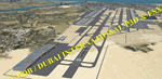
OMDB - GPS-accurate scenery based om Google maps and the FlyTampa base AFCAD (default FSX/P3D AFCAD). Every Runway, Gate and taxiway is right on the actual spot with a very small error margin.
Two types of Jetway structures used for Terminals 1 & 3, and are made by Victor Nauta. The new Concourse-D terminal for airlines other than Emirates is now added, with a basic terminal building design using Google Sketchup for better visuals.
WHAT'S NEW:
- The new Concourse-D terminal east of the existing Terminal 1. Terminal replaces the old Emirates Sky Cargo terminal, and servers all other visiting airlines.
- Apron Q used by FlyDubai is added.
- Extra runway rapid exits added.
- Extra parking gates in the C apron according to the latest charts.
- Extra Taxiways connecting to the runways according to the charts.
- Ground marking for Gates and taxiways! (A, B, C, D and F aprons)
- Aprons G and S are added according to the latest Airport layout and charts.
| Filename: | OMDB__Dubai_Intl_Airport__Dubai_UAE.zip |
| License: | Freeware, limited distribution |
| Added: | 25th July 2016, 20:17:21 |
| Downloads: | 10,973 |
| Author: | Ahmed Abdessalam |
| Size: | 4.16 MB |
| Category: Flight Simulator X - Scenery | |
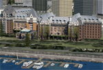
| Victoria, Canada including US Southern Gulf Islands and San Juan Islands - Part 2 of 2 |
|
Images related to this file:
File Description:

FSX-only version of Victoria, Canada area scenery including the Southern Gulf Islands and the San Juan Islands of the US. Includes automated installer and configurator by Scot Fraser.
Features:
-accurate shorelines, lakes and streams;
-landclass;
-FSX multi-LOD mesh with 10m maximum resolution;
-complete road network with moving traffic;
-railroads;
-utility corridors;
-marinas and ferry terminals;
-many static boats, including a custom model of the Canada Coast Guard ship Sir Wilfred Laurier;
-detailed models of major buildings and the Ogden Point Terminal;
-many bridges;
-nearly 300 marine lights; and corrected antennae locations.
Facilities include Don Grovestine's famous CYYJ (Victoria International Airport); 12 other Canadian land-based airports: Butler Field, Duncan (CAM3), Gaines, Hastings, Hudson Island, James Island, Thomas, Village Bay, Raven Field (CML2), Saltspring, Sidney Island, Whiskey Point; 20 US airports Blakely (38WA), Burden (61WA), Center Island (79WA), Clam Harbor (WA35), Crane Island, Decatur Shores (WN07), Decatur-Jones (WA18), Waldronaire (90WA), Orcas Island (KORS), Friday Harbour (KFHR), Lopez Island (S31), Pile Point, Roche Harbor (WA09), Shaw Island, Stuart Island Airpark (7WA5), Stuart Island West (2WA3), Wilding (6WA5), Windsock (4WA4); 12 floatplane facilities: Bedwell (CAB3), Fisherman's Bay (WA81), Friday Harbor (W33), Ganges (CAX6), Maple Bay, Mayne (CAW7), Port Washington (CAP8), Roche Harbor (W39), Rosario (W49), Shawnigan Lake (CAV8), Victoria Harbour (CYWH), Victoria International (CAP5) and Westsound, Orcas (WA83) - many with AI traffic; 9 heliports: Ganges (CAL7), Mayne (CBF5), Camel Point (CBF7), Jubilee (CBK8), Victoria General (CBW7) Madrona Bay (CBW9), Shoal Point (CBZ7), Mount Belcher (CMBH).
AI models include the DHC-2 floatplane in local liveries, a cruise ship model (by Mitsuya Hamaguchi) and two repaints, pilot boat, and small boats (by Larry Silsbee).
Ultimate Terrain X compatible (not required). Users of Vancouver+ for FSX will also get additional cruise ship traffic and additional floatplane and helicopter traffic. Full documentation. By Don Grovestine, Jon Patch and Holger Sandmann. Many other contributors: see documentation. Part 2 of 2 - you also need file vicenh7a.zip
| Filename: | Victoria_Canada_including_US_Southern_Gulf_Islands.zip |
| License: | Check within download |
| Added: | 29th January 2010, 21:21:49 |
| Downloads: | 23,161 |
| Author: | Don Grovestine, Jon Patch and Holger Sandmann |
| Size: | 59.08 MB |
| Category: Flight Simulator X - Scenery | |
| Victoria, Canada including US Southern Gulf Islands and San Juan Islands - Part 1 of 2 |
|
Images related to this file:
File Description:
FSX-only version of Victoria, Canada area scenery including the Southern Gulf Islands and the San Juan Islands of the US. Includes automated installer and configurator by Scot Fraser.
Features:
-accurate shorelines, lakes and streams;
-landclass;
-FSX multi-LOD mesh with 10m maximum resolution;
-complete road network with moving traffic;
-railroads;
-utility corridors;
-marinas and ferry terminals;
-many static boats, including a custom model of the Canada Coast Guard ship Sir Wilfred Laurier;
-detailed models of major buildings and the Ogden Point Terminal;
-many bridges;
-nearly 300 marine lights; and corrected antennae locations.
Facilities include Don Grovestine's famous CYYJ (Victoria International Airport); 12 other Canadian land-based airports: Butler Field, Duncan (CAM3), Gaines, Hastings, Hudson Island, James Island, Thomas, Village Bay, Raven Field (CML2), Saltspring, Sidney Island, Whiskey Point; 20 US airports Blakely (38WA), Burden (61WA), Center Island (79WA), Clam Harbor (WA35), Crane Island, Decatur Shores (WN07), Decatur-Jones (WA18), Waldronaire (90WA), Orcas Island (KORS), Friday Harbour (KFHR), Lopez Island (S31), Pile Point, Roche Harbor (WA09), Shaw Island, Stuart Island Airpark (7WA5), Stuart Island West (2WA3), Wilding (6WA5), Windsock (4WA4); 12 floatplane facilities: Bedwell (CAB3), Fisherman's Bay (WA81), Friday Harbor (W33), Ganges (CAX6), Maple Bay, Mayne (CAW7), Port Washington (CAP8), Roche Harbor (W39), Rosario (W49), Shawnigan Lake (CAV8), Victoria Harbour (CYWH), Victoria International (CAP5) and Westsound, Orcas (WA83) - many with AI traffic; 9 heliports: Ganges (CAL7), Mayne (CBF5), Camel Point (CBF7), Jubilee (CBK8), Victoria General (CBW7) Madrona Bay (CBW9), Shoal Point (CBZ7), Mount Belcher (CMBH).
AI models include the DHC-2 floatplane in local liveries, a cruise ship model (by Mitsuya Hamaguchi) and two repaints, pilot boat, and small boats (by Larry Silsbee).
Ultimate Terrain X compatible (not required). Users of Vancouver+ for FSX will also get additional cruise ship traffic and additional floatplane and helicopter traffic. Full documentation. By Don Grovestine, Jon Patch and Holger Sandmann. Many other contributors: see documentation. Part 1 of 2 - you also need file vicenh7b.zip
| Filename: | Victoria_Canada_including_US_Southern_Gulf_Islands.zip |
| License: | Check within download |
| Added: | 29th January 2010, 21:23:17 |
| Downloads: | 23,158 |
| Author: | Don Grovestine, Jon Patch and Holger Sandmann |
| Size: | 56.8 MB |
| Category: Flight Simulator 2004 - AI Aircraft | |
| Sukhoi Su-15 Flagon |
|
Images related to this file:
File Description:

Sukhoi Su-15 Flagon. I present a comprehensive AI traffic model package for this cold warrior of military jet history. Going into production in 1962, 1,290 aircraft served thirty-four years in the Soviet, Russian, and Ukrainian air forces. The Su-15 was designed as a follow-on interceptor to the Su-9/11 series, and had the notoriety of being the shoot-down aircraft in the Korean Airlines Flight 007 incident in 1983. An original 7-LOD model brings this historic aircraft to the flightsim world. This package represents the Su-15 (in five model variations) through the span of its entire career with the Soviet Union, Russian Federation, and Ukraine; with a total of 20 models and 58 repaints. Additional paints cover unofficial use by Egypt in the 1970s, and a short, unfulfilled ownership by Georgia after the Soviet break-up (Georgia traded up for Su-25s). Original aircraft model, flight dynamics, and textures by Michael Pearson. Please read included documentation.
| Filename: | Sukhoi_Su15_Flagon.zip |
| License: | Freeware |
| Added: | 28th January 2014, 21:53:43 |
| Downloads: | 481 |
| Author: | Michael Pearson |
| Size: | 27.54 MB |
| Category: Flight Simulator 2004 - Aircraft Repaints, Textures and Modifications | |
| Simorgh Air Boeing 737-900ER |
|
File Description:
Simorgh Air is the fastest growing virtual airline of Iran with an expanding fleet of F100 and B737 aircrafts at this moment. The VA is expected to become the most powerful in the region in near future; Also a great fleet and flightplans planning for future will make it possible for the VA to offer unique services to passengers even in real world; Simorgh Air is going to be ranked the first VA in connecting passengers worldwide.
Boeing 737-900ER a present from Project OpenSky team which contains all the features from the 737-900 released earlier this year. Additional features: 2-Position tailskid and a refined Spoiler timing. Model features: A refined dynamic wing flex system that respond to turbulence. Fully Animated control surfaces, pushback truck with animated ground crew, opening doors & cargodoors, accurate FDE, highly detailed textures, and lots more that you'll just have to find! Painted with a self-made paintkit based on the official paintkit by Corey Ford. Textures Only.
| Filename: | Simorgh_Air_Boeing_737900ER.zip |
| License: | Freeware, limited distribution |
| Added: | 1st April 2008, 08:58:05 |
| Downloads: | 637 |
| Author: | Project Opensky | Mostafa Ayoobzadeh |
| Size: | 5.99 MB |
© 2001-2026 AVSIM Online
All Rights Reserved
Privacy Policy |