
Where Flight Simulation Enthusiasts Gather from Around the World!
AVSIM Library - Search Results

| Category: Flight Simulator 2004 - Helicopters | |
| Bell 206B III JetRanger "TV News expansion and update" |

|
Images related to this file:
File Description:
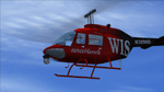
This is a scratch built revision of the default Bell 206B III JetRanger using Gmax. Features highly detailed exterior and virtual cockpit, maximum moving parts, interactive VC, dynamic shine, and reflective textures. This package updates the original TV model which had a bad texture map in the upper wirecutter and adds 3 additional TV News models/textures including the never been released WIS-TV Newshawk version as built and painted by Owen Hewitt
| Filename: | Bell_206B_III_JetRanger_TV_News_expansion_and_upda.zip |
| License: | Freeware, limited distribution |
| Added: | 20th August 2011, 10:04:10 |
| Downloads: | 599 |
| Author: | Owen Hewitt, George A.Arana |
| Size: | 14.23 MB |
| Category: Flight Simulator X - AI Aircraft | |
| Ukraine International Airlines Boeing 737-300 Fleet |
|
Images related to this file:
File Description:
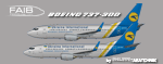
Ukraine International Boeing 737-300 fleet. Includes UR-GAN in the standard livery, UR-GAQ with additional internet titles, and UR-GAH named 'Mowgli' with nose art. To be used with the brand new FAIB Boeing 737-300 (winglets model) base package available separately. The enclosed textures are native fsx HD textures, that will ONLY show in fsx. If you are using fs9, please download instead the file faib_733_aui_fleet_fs9.zip. Repaint by Philippe Tabatchnik.
| Filename: | Ukraine_International_Airlines_Boeing_737300_Fleet.zip |
| License: | Freeware, limited distribution |
| Added: | 26th July 2012, 22:13:18 |
| Downloads: | 948 |
| Author: | Philippe Tabatchnik |
| Size: | 2.49 MB |
| Category: Flight Simulator 2004 - Aircraft Repaints, Textures and Modifications | |
| Monarch Airlines Airbus A320 |
|
Images related to this file:
File Description:
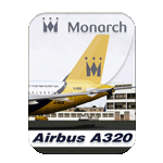
Monarch, is a British airline based at Luton Airport,operating scheduled flights to destinations in the Mediterranean, Canary Islands, Cyprus, Egypt, Greece and Turkey, with additional charter services to Europe, the United States, the Caribbean, India and Africa. Monarch Airlines (G-MONX) Old (G-MRJK) New Photoreal textures in 32 bit for freeware Project Airbus A320 v2.1 (model not included; get it at the Project Airbus website). Repaint by: Manuel Jose, Contact Ground. Happy flights.
| Filename: | Monarch_Airlines_Airbus_A320.zip |
| License: | Freeware |
| Added: | 26th November 2013, 14:51:40 |
| Downloads: | 499 |
| Author: | Manuel Jose Larrahondo Burgos |
| Size: | 20.8 MB |
| Category: Flight Simulator X - Aircraft Repaints, Textures and Modifications | |
| Japan Airlines Airbus A350-941/XWB (JA901J) |
|
Images related to this file:
File Description:

Fictional (for now) repaint of the Japan Airlines Airbus A350-941/XWB for the AI Traffic FSP Airbus A350. This paint is designed to work in FSX only. JAL have 18 A359's on order with an additional 13 A35K's including 25 options. A JAL repaint will be made when FSP designs the A35K model. Textures only, you will need the freeware AI Traffic FSP Airbus A350 model for this repaint to work.
| Filename: | Japan_Airlines_Airbus_A350941XWB_JA901J.zip |
| License: | Freeware |
| Added: | 9th February 2016, 11:22:18 |
| Downloads: | 1,097 |
| Author: | Adam Hamada & FSPainter |
| Size: | 4.31 MB |
| Category: Flight Simulator 2004 - Aircraft Repaints, Textures and Modifications | |
| Cargojet Purolator Boeing 767-39H(F)ER WL (C-FGSJ) |
|
Images related to this file:
File Description:
SkySpirit Boeing 767-39H(F)(ER)(WL) Cargojet Purolator (C-FGSJ). Cargojet provides a comprehensive Canada-wide air cargo services for the Canada Post Group of Companies, including Purolator’s national air cargo network. Cargojet’s domestic air cargo network has been expanded and enhanced significantly to handle the additional volumes and provide improved service to all customers. Model design by Hiroshi Igami.
| Filename: | Cargojet_Purolator_Boeing_76739HFER_WL_CFGSJ.zip |
| License: | Freeware, limited distribution |
| Added: | 23rd May 2016, 19:37:48 |
| Downloads: | 419 |
| Author: | Danny Cummings |
| Size: | 12.37 MB |
| Category: Flight Simulator X - AI Aircraft | |
| Martinair Boeing 747-21AC/SCD 1998 textures |
|
Images related to this file:
File Description:
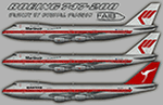
Martinair Boeing 747-21AC/SCD 1998 textures for retro AI traffic, with 3 variations, utlizing the FAIB 747-200 GE model set. These two aircraft were not in the original release I did, and I am adding an additional (3rd) texture, the 1988 Qantas lease of PH-MCF. This package includes FS9 32-bit and FSX/P3D 2048 DDS DXT5 textures. Aircraft model and master paint kit by Erez Weber, repaints by Michael Pearson.
| Filename: | Martinair_Boeing_74721ACSCD_1998_textures.zip |
| License: | Freeware |
| Added: | 27th March 2019, 02:03:58 |
| Downloads: | 279 |
| Author: | Michael Pearson |
| Size: | 7.9 MB |
| Category: Flight Simulator 2004 - AI Flight Plans | |
| JamboJet (Kenya) - Summer 2014 |
|
Images related to this file:
File Description:

Flight plans for JamboJet (Kenya) Summer 2014. What's new?
The flight, which will begin operation in April 1 is set to change the air travel industry in Kenya and attract road travellers in additional to taking competition in the aviation industry a notch higher.
JamboJet is scheduled to first fly to Kisumu, Eldoret and Mombasa from Nairobi before proceeding to the other neighboring countries in years time. By Kamil Fryzol
| Filename: | JamboJet_Kenya__Summer_2014.zip |
| License: | Freeware |
| Added: | 6th April 2014, 22:49:49 |
| Downloads: | 345 |
| Author: | Kamil Fryzol |
| Size: | 8.03 KB |
| Category: Flight Simulator X - Scenery | |
| LSZB Bern Belp, Switzerland for FSX (P3D) Version1.0 Update-01 |
|
File Description: This is just a technical update, which corrects some issues in the airport-layout.
With this update the AI-Traffic now should work correctly and also the fuel truck should now be aviable via “Shift Fâ€. Additional some taxiways and some parking positions are modified. For this update you have to install my LSZB Bern-Belp scenery Version 1.0 first.
LINK:
https://library.avsim.net/search.php?SearchTerm=LSZB&CatID=fsxscen&Go=Search
| Filename: | LSZB_Bern_Belp_Switzerland_for_FSX_P3D_Version10_U.zip |
| License: | Freeware |
| Added: | 6th July 2017, 18:29:07 |
| Downloads: | 2,453 |
| Author: | Wolfgang Allers, Gabriele Marchini |
| Size: | 19.86 KB |
| Category: Flight Simulator X - AI Aircraft | |
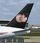
| South African Airbus A340-600 v1 |
|
Images related to this file:
File Description:
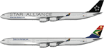
This package contains repaints for the South African A340-600s Both ZS-SNB, a standard livery, and ZS-SNC, the Star Alliance livery, are included. These are textures only. The FSPainter A340-600 base model is required. It can be bought from http://secure.simmarket.com/fspxai-airbus-a340-fsxp3d-ai-traffic.phtml
V1 changes include resizing of 'Star Alliance' to match real life as well as additional warnings added to nose gear doors and static ports
| Filename: | South_African_Airbus_A340600_v1.zip |
| License: | Freeware |
| Added: | 2nd August 2017, 16:59:04 |
| Downloads: | 205 |
| Author: | Brian Swintal |
| Size: | 7.58 MB |
| Category: Flight Simulator 2004 - AI Aircraft | |
| Update for MPAI C-46 Commando |
|
Images related to this file:
File Description:

Update for the MPAI C-46 Commando AI Traffic model. This is a critical update which fixes a couple of things, which are listed in the readme file. Also, as usual, I compensate the inconvenience with more eye candy, as this package includes corrected models and two dozen additional repaints. This is a simple copy-and-overwrite update for the original aircraft file "mpai_c-46_traffic.zip". Aircraft model, flight dynamics, and repaints by Michael Pearson.
| Filename: | Update_for_MPAI_C46_Commando.zip |
| License: | Freeware |
| Added: | 11th September 2017, 22:42:22 |
| Downloads: | 482 |
| Author: | Michael Pearson |
| Size: | 9.64 MB |
© 2001-2026 AVSIM Online
All Rights Reserved
Privacy Policy |