
Where Flight Simulation Enthusiasts Gather from Around the World!
AVSIM Library - Search Results

| Category: Flight Simulator 2004 - AI Aircraft | |
| German Air Force Airbus A310 repaints |

|
Images related to this file:
File Description:
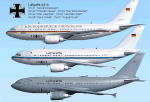
Repaints of the Airbus A310-304 in German Air Force 10+21 (new colour), 10+22 and 10+23 VIP schemes for those special visitors and 10+24 to 10+27 grey MRT (Multi Role Transporter) scheme (has the cargo door on the forward port side). Dynamic shine, subtle stainless steel and chrome effects, wing shading. Custom light maps for each texture, too. You need the A310-GE model by FSPainter. Requires: http://library.avsim.net/search.php?SearchTerm=ai_airbus_complete_120685.zip&CatID=root&Go=Search
| Filename: | German_Air_Force_Airbus_A310_repaints.zip |
| License: | Freeware, limited distribution |
| Added: | 14th July 2012, 15:36:12 |
| Downloads: | 508 |
| Author: | Al Percy |
| Size: | 2.37 MB |
| Category: Flight Simulator X - AFCAD Files | |
| YSBK - Bankstown Airport - Bankstown, Australia |
|
Images related to this file:
File Description:
Bankstown Airport is a general aviation airport and business park located in the City of Bankstown, 22 km (14 mi) from the central business district of Sydney, Australia. The airport is situated on 313 ha (770 acres) of land and has three parallel runways, several apron areas, a small passenger terminal and a business park, home to over 170 businesses.
Using ADEx 1.55, aeronautical maps and Google Earth the default AFCAD has been completely reworked to reflect today´s situation.
| Filename: | YSBK__Bankstown_Airport__Bankstown_Australia.zip |
| License: | Freeware |
| Added: | 4th January 2014, 18:12:35 |
| Downloads: | 703 |
| Author: | Menno C. Robert |
| Size: | 624.49 KB |
| Category: Flight Simulator X - Scenery | |
| KEMV - Emporia-Greenville Regional Airport - Virginia - USA |
|
Images related to this file:
File Description:
The airport is located 3 miles east of Emporia.
The runway was changed from 15/33 to 16/34. AirNav continues to list the runway as 15/33.
Changes were made based on Google Maps. Created with Airport Design Editor by ScruffyDuck Software using current FAA documentation and Google Earth measurements, this package offers a replacement for FSX's stock airport. All these enhancements are as close to the real airport as I can get with stock library objects.
| Filename: | KEMV__EmporiaGreenville_Regional_Airport__Virginia.zip |
| License: | Freeware |
| Added: | 11th September 2014, 00:41:51 |
| Downloads: | 300 |
| Author: | Wayne Roberts |
| Size: | 34.19 KB |
| Category: Fly! II - Development | |
| Amp2Xml |
|
File Description:
Amp2Xml.exe converts the aircraft amp file (electric subsystems) to a xml file.
Xml files are standard files : you can examine them with Internet Explorer (> 5.0) and find a lot of usefull tools on the web to get trees, maps etc...
As amp file is hard to read and the "hires" are hard to follow, I thought it would be a good idea to prepare some tools based on xlm files because there's a large class library for xml files on the web...
| Filename: | Amp2Xml.zip |
| License: | Freeware |
| Added: | 22nd September 2002, 17:29:54 |
| Downloads: | 220 |
| Author: | ROTW team |
| Size: | 75.98 KB |
| Category: Flight Simulator 2002 - Original Aircraft | |
| Olympic Airways Boeing 737-284 |
|
File Description:
A fs732 designed acording real 732 specs, maded in GMAX for fs2002 only . with all the new exciting
features from fs2002. including maximum acurate animations,42 sided fuselage,compresing struts, virtual cockpit
with working gauges and moving yokes, animated reversers,fs2k2 style lighting and night texturing, reflective maps
rolling wheels, engine smoke, steerable front landing gear, transparent canopy with 3d interiors and 3d pilots,
high quality 1024x1024 night and day DXT3 textures,acurate especial fs2k2 flight dynamics.
includes a frame rates friend panel.
| Filename: | Olympic_Airways_Boeing_737284.zip |
| License: | Freeware |
| Added: | 29th June 2002, 18:48:25 |
| Downloads: | 1,992 |
| Author: | Maximos Sevastopoulos |
| Size: | 1.53 MB |
| Category: Flight Simulator 2002 - Scenery | |
| NW Louisiana Soaring, Cajun Style |
|
File Description:
Try the soaring in this part of the country, NW Louisiana and even into the southwest corner of Arkansas and maybe just a wee bit of East Texas. Launch from down Shreveport way or even from Magnolia, Arkansas or maybe from Texarkana. Review the included maps and set up your own journey through the area. A flight is included that gives you a launch site of Belcher,LA just north of Shreveport since the gliding club of Shreveport has a field nearby.
| Filename: | NW_Louisiana_Soaring_Cajun_Style.zip |
| License: | Freeware |
| Added: | 10th February 2003, 22:45:35 |
| Downloads: | 378 |
| Author: | David L Thompson |
| Size: | 371.76 KB |
| Category: Flight Simulator 2004 - Aircraft Repaints, Textures and Modifications | |
| Cessna 196/LC-126 Unmarked-Lo Shine - LO-RES DXT-3 |
|
File Description:
These are textures only and require filename: shakey_jake.zip which can be found here in the AVSIM library.
It has been a great pleasure working with the gang in providing this aircraft for your pleasure. These textures are a bare metal surface with no markings of any sort. I am providing these for those who may wish to add their own markings or livery. The external textures are saved in a hi-resolution 32-bit format with no mip-maps. Enjoy!
| Filename: | Cessna_196LC126_UnmarkedLo_Shine__LORES_DXT3.zip |
| License: | Freeware |
| Added: | 29th November 2003, 05:00:42 |
| Downloads: | 145 |
| Author: | Heather Sherman |
| Size: | 1.97 MB |
| Category: Flight Simulator 2004 - Aircraft Repaints, Textures and Modifications | |
| Cessna 196/LC-126 Unmarked-Lo Shine - LO-RES DXT-3 |
|
File Description:
These are textures only and require filename: shakey_jake.zip which can be found here in the AVSIM library.
It has been a great pleasure working with the gang in providing this aircraft for your pleasure. These textures are a bare metal surface with no markings of any sort. I am providing these for those who may wish to add their own markings or livery. The external textures are saved in a hi-resolution 32-bit format with no mip-maps. Enjoy!
| Filename: | Cessna_196LC126_UnmarkedLo_Shine__LORES_DXT3.zip |
| License: | Freeware, limited distribution |
| Added: | 29th November 2003, 05:02:35 |
| Downloads: | 247 |
| Author: | Heather Sherman |
| Size: | 2 MB |
| Category: Flight Simulator 2004 - Aircraft Repaints, Textures and Modifications | |
| Margarita Air Club Midnight Magic Beech Baron 58 |
|
File Description:
These are textures only and are applied to the default FS2004 Beech Baron 58. These are 32-bit 888-8 format textures with no mip-maps.
This is not one of the easier aircraft to paint due to its extensive rivet and seam detailing and was instrumental in my finally learning how to "layer" with PSP. I wish to thank Chris Klein and Bob Hayes for the use of their Beech Baron 58 Repaint Kit. Really saved a LOT of tedious work.
| Filename: | Margarita_Air_Club_Midnight_Magic_Beech_Baron_58.zip |
| License: | Freeware, limited distribution |
| Added: | 30th November 2003, 13:19:16 |
| Downloads: | 2,238 |
| Author: | Heather Sherman |
| Size: | 2.03 MB |
| Category: Flight Simulator 2004 - Aircraft Repaints, Textures and Modifications | |
| Margarita Air Club - Midnight Magic Beech Baron 58 (Low-Resolution) |
|
File Description:
These are textures only and are applied to the default FS2004 Beech Baron 58. These are DXT-3 format textures with no mip-maps.
This is not one of the easier aircraft to paint due to its extensive rivet and seam detailing and was instrumental in my finally learning how to "layer" with PSP. I wish to thank Chris Klein and Bob Hayes for the use of their Beech Baron 58 Repaint Kit. Really saved a LOT of tedious work.
| Filename: | Margarita_Air_Club__Midnight_Magic_Beech_Baron_58_.zip |
| License: | Freeware, limited distribution |
| Added: | 30th November 2003, 13:24:25 |
| Downloads: | 1,401 |
| Author: | Heather Sherman |
| Size: | 744.17 KB |
© 2001-2026 AVSIM Online
All Rights Reserved
Privacy Policy |