
Where Flight Simulation Enthusiasts Gather from Around the World!
AVSIM Library - Search Results

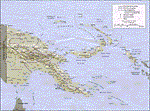
| Category: Navigation and ATC - Navigation | |
| Papua New Guinea charts 1 of 3 |

|
Images related to this file:
File Description:

Calibrated for FSMap, but scanned images can be used in other map software, such as FSM Moving Map (FSMMM) by Rana Hossain. Chart source: Topographic Maps U.S. Army Map Service, Series T504, original scale 1:250,000, date 1964-. Courtesy of the University of Texas Libraries, The University of Texas at Austin. Missing: I could not find equivalent charts for New Britain; for this island, a lower-quality chart is included.
| Filename: | Papua_New_Guinea_charts_1_of_3.zip |
| License: | Freeware |
| Added: | 5th June 2010, 03:40:04 |
| Downloads: | 1,213 |
| Author: | David Wilson-Okamura |
| Size: | 34.25 MB |
| Category: Navigation and ATC - Navigation | |
| Papua New Guinea charts for FSMMM |
|
Images related to this file:
File Description:

Re-upload. What these are: calibration files for use with Rana Hossain's freeware program FSM Moving Map (FSMMM) and the PNG Charts hosted by the AVSIM file library. What these are not: the charts themselves. In order to use the charts, you will need to download three additional files, which are much larger than this one: png_charts_1.zip (35mb), png_charts_2.zip (35mb), and png_charts_3.zip (36mb). Why not package everything together? To minimize file size. The original image files, which are quite large, were uploaded to AVSIM and calibrated for the payware program FSMap by David Wilson-Okamura. Within a few days, downloaders started asking how to use the charts with the freeware program FSMMM. New charts (which are quite large to store and download) weren't needed, just new calibration files (which are quite small). These were created by TERRY CARR, who is the hero of this download. To use the charts with FSMMM, first download all four of the files listed here, including this one. You don't need to download FSMMM again if you already have that installed.) Unzip all of them into the folder where you keep your FSMMM charts. Then run FSMMM and use the mass import feature. If you don't know how to do that, please read the manual or, if that doesn't help, Google is your friend.
| Filename: | Papua_New_Guinea_charts_for_FSMMM.zip |
| License: | Freeware |
| Added: | 5th June 2010, 05:21:06 |
| Downloads: | 542 |
| Author: | Terry Carr, David Wilson-Okamura |
| Size: | 11.97 KB |
| Category: Navigation and ATC - Navigation | |
| Papua New Guinea charts 3 of 3 |
|
Images related to this file:
File Description:
Re-upload. Calibrated for FSMap, but scanned images can be used in other map software, such as FSM Moving Map (FSMMM) by Rana Hossain. Chart source: Topographic Maps U.S. Army Map Service, Series T504, original scale 1:250,000, date 1964-. Courtesy of the University of Texas Libraries, The University of Texas at Austin. Missing: I could not find equivalent charts for New Britain; for this island, a lower-quality chart is included.
| Filename: | Papua_New_Guinea_charts_3_of_3.zip |
| License: | Freeware |
| Added: | 5th June 2010, 05:26:20 |
| Downloads: | 515 |
| Author: | David Wilson-Okamura |
| Size: | 35.88 MB |
| Category: Navigation and ATC - Navigation | |
| Enroute Charts of the United States, Part 1 |
|
File Description:
12 High Altitude Enroute Charts for the Lower 48 United States. These are the original high resolution PDF maps available from National Aeronautical Charting Office (NACO). THESE ARE NOT CURRENT THEY MUST NOT BE USED FOR REAL WORLD NAVIGATION!!!!!
| Filename: | Enroute_Charts_of_the_United_States_Part_1.zip |
| License: | Freeware |
| Added: | 12th January 2010, 09:03:11 |
| Downloads: | 2,488 |
| Author: | Matt Fox |
| Size: | 89.98 MB |
| Category: Navigation and ATC - Navigation | |
| Enroute Charts of the United States, Part 2 |
|
File Description:
Enroute Charts for the United States - Part 2 - High Altitude Lower 48 US and Alaska for Moving Map Displays.
This version is intended for moving map systems. The original PDF maps have been down-sampled and processed to remove the map borders. They were then reprojected to Geographic coordinate system and converted to 8 bit TIFF files.
THESE ARE NOT CURRENT!!!! THEY MUST NOT BE USED FOR REAL WORLD NAVIGATION!!!!!
| Filename: | Enroute_Charts_of_the_United_States_Part_2.zip |
| License: | Freeware |
| Added: | 12th January 2010, 09:04:25 |
| Downloads: | 1,195 |
| Author: | Matt Fox |
| Size: | 23.41 MB |
| Category: Navigation and ATC - Navigation | |
| Enroute Charts of the United States, Part 3 |
|
File Description:
Enroute Charts for the United States. Part 3 - High Altitude Alaska, Caribbean and Pacific.
6 High Altitude Enroute Charts for Alaska, Caribbean and Pacific. These are the high resolution PDF maps available from National Aeronautical Charting Offic (NACO) https://naco.faa.gov/. THESE ARE NOT CURRENT!!!! THEY MUST NOT BE USED FOR REAL WORLD NAVIGATION!!!!!
| Filename: | Enroute_Charts_of_the_United_States_Part_3.zip |
| License: | Freeware |
| Added: | 12th January 2010, 09:05:52 |
| Downloads: | 1,166 |
| Author: | Matt Fox |
| Size: | 48.43 MB |
| Category: Navigation and ATC - Navigation | |
| Enroute Charts of the United States, Part 4 |
|
File Description:
18 High Altitude Enroute Charts for Lower 48 United States, Alaska, Caribbean and Pacific. This version of the maps has been downsampled to 250-300 dpi and converted to PNG format. These are smaller files and much easier to view than the original PDF maps. THESE ARE NOT CURRENT!!!! THEY MUST NOT BE USED FOR REAL WORLD NAVIGATION!!!!!
| Filename: | Enroute_Charts_of_the_United_States_Part_4.zip |
| License: | Freeware |
| Added: | 12th January 2010, 09:07:15 |
| Downloads: | 1,469 |
| Author: | Matt Fox |
| Size: | 69.8 MB |
| Category: Online ATC - Software | |
| Aegean Airlines NEW Servinfo Logo |
|
Images related to this file:
File Description:
![]()
Aegean Airlines NEW Servinfo Logo
| Filename: | Aegean_Airlines_NEW_Servinfo_Logo.zip |
| License: | Freeware, limited distribution |
| Added: | 2nd January 2010, 15:32:27 |
| Downloads: | 617 |
| Author: | Christopher Barbas |
| Size: | 11.43 KB |
| Category: Online ATC - Software | |
| Dolomynum v1.2.5 |
|
Images related to this file:
File Description:

Dolomynum (also known as DLMN or Don't Lose My Number) is a very fast, lightweight open-source tool to show the traffic of online flying networks such as IVAO and VATSIM (similar to Servinfo). Traffic can be viewed on a 3D OpenGL map, in lists, or on a console. Licensed as open source; package also contains source code and sector converter / viewer tools. This new version (v1.2.5) updates data files and fixes some bugs. For more information, please read the included manual and visit the website of the project.
| Filename: | Dolomynum_v125.zip |
| License: | Check within download |
| Added: | 5th January 2010, 12:41:55 |
| Downloads: | 31,740 |
| Author: | Gergely Kosa |
| Size: | 1.91 MB |
| Category: Navigation and ATC - Navigation | |
| Wichita Chart Chunks Optimized For Moving Map Application |
|
File Description:
Sectional chart chunks made from the August 2009 Sectional charts at the original scale, formatted in the WGS84 lat/lon geographic coordinate system for GPS, moving map application for flight simulation use.
These chart chunks were converted to the JPEG format for compatibility and size. Coverage is the full Sectional area North and South divided into 8 JPEG tiles. They are about 3k x 3k pixels at 7mb with coverage of 90nm x 130nm per tile. Included is also the projection files and world files.
| Filename: | Wichita_Chart_Chunks_Optimized_For_Moving_Map_Appl.zip |
| License: | Freeware |
| Added: | 20th February 2010, 14:47:57 |
| Downloads: | 114 |
| Author: | David Myers |
| Size: | 15.38 MB |
© 2001-2026 AVSIM Online
All Rights Reserved
Privacy Policy |