
Where Flight Simulation Enthusiasts Gather from Around the World!
AVSIM Library - Search Results

| Category: Navigation and ATC - Navigation | |
| High Resolution Western Aleutian Islands West Sectional Chart |

|
File Description:
Very high resolution georeferenced Sectional Chart. Converted to JPG format to reduce size of download. However, very little compression artifacts are visible to keep high image quality. Includes projection files if you want to use with GIS software.
| Filename: | High_Resolution_Western_Aleutian_Islands_West_Sect.zip |
| License: | Freeware |
| Added: | 23rd August 2004, 04:16:19 |
| Downloads: | 1,039 |
| Author: | Matt Fox |
| Size: | 1.69 MB |
| Category: Navigation and ATC - Navigation | |
| Airport Charts of the World |
|
File Description:
Package of 100 airport charts calibrated for use in FSM Moving Map (FSMMM) by Rana Hossain. Zip dive to see which airports are included.
| Filename: | Airport_Charts_of_the_World.zip |
| License: | Freeware |
| Added: | 21st March 2005, 07:08:05 |
| Downloads: | 9,304 |
| Author: | Matt Fox |
| Size: | 10.79 MB |
| Category: Navigation and ATC - Navigation | |
| Klamath Falls Chart Chunks Optimized For Moving Map Application |
|
File Description:
Sectional chart chunks made from the August 2009 Sectional charts at the original scale, formatted in the WGS84 lat/lon geographic coordinate system for GPS, moving map application for flight simulation use.
These chart chunks were converted to the JPEG format for compatibility and size. Coverage is the full Sectional area North and South divided into 8 JPEG tiles. They are about 3k x 3k pixels at 2.5mb with coverage of 90nm x 130nm per tile. Included is also the projection files and world files.
Note: This type of map is a equal grid and no further calibration is needed, only the two points referenced in the world file. Example: for users of FSM Moving Map, just mass import, done.
| Filename: | Klamath_Falls_Chart_Chunks_Optimized_For_Moving_Ma.zip |
| License: | Freeware |
| Added: | 20th February 2010, 23:07:41 |
| Downloads: | 107 |
| Author: | David Myers |
| Size: | 21.37 MB |
| Category: Navigation and ATC - Navigation | |
| Tutorial: Flying IFR |
|
Images related to this file:
File Description:

Tutorial: Flying IFR is an Adobe PDF file containing all of the Instrument Flying Rules (IFR) lessons written by Andrew Ayers, applicable for use in a flight simulator. These lessons were previously published on the AVSIM Educational Resource Center as a Special Edition Tutorial.
Author: Andrew Ayers ([email protected])
| Filename: | Tutorial_Flying_IFR.zip |
| License: | Freeware |
| Added: | 14th October 2021, 00:11:38 |
| Downloads: | 207 |
| Author: | Andrew Ayers |
| Size: | 4.93 MB |
| Category: Navigation and ATC - Navigation | |
| Italian Airports Charts and Procedures Series 2 Update 14_11_2013 |
|
File Description:
All Italian Airports in PDF Format to use with ChartMap vers. 5.0. This is the second of three series.
| Filename: | Italian_Airports_Charts_and_Procedures_Series_2_Up.zip |
| License: | Freeware |
| Added: | 24th November 2013, 05:55:56 |
| Downloads: | 193 |
| Author: | Carlo Chiappisi |
| Size: | 85.99 MB |
| Category: Navigation and ATC - Navigation | |
| Italian Airports Charts and Procedures Series 3 Update 14_11_2013 |
|
File Description:
All Italian Airports to use with ChartMap 5.0. This is the last file of the series.
Download ChartMap 5.0
| Filename: | Italian_Airports_Charts_and_Procedures_Series_3_Up.zip |
| License: | Freeware |
| Added: | 24th November 2013, 05:56:35 |
| Downloads: | 229 |
| Author: | Carlo Chiappisi |
| Size: | 78.44 MB |
| Category: Navigation and ATC - Navigation | |
| LSZS - Samedan visual approach chart v3 |
|
Images related to this file:
File Description:
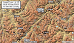
Custom made visual approach chart and pilot's briefing for Engadin (St. Moritz) Samedan LSZS airport in Switzerland, Europe's highest elevation airport (5,600 ft.) situated in the Swiss Alps. This airport is a day VFR operations only and has no instrument approach due to extreme terrain around it. A demanding visual descent into a canyon, in between steep rising terrain, is required to make the visual approaches for both runways with a steep 4.4* degrees final approach portion guided by the PAPI's. Still, executive jets up to Boeing 737(BBJ) size approach the airport often in the winter peak season VFR with these procedures. It is designed as per real operators' pilot briefing for Samedan. Real airport's full pilot briefing document also included. The real airport's excellent briefing (included) intentionally does not contain the maneuvers needed for the approach of jets through the mountains but only reporting points for all and maneuvers for light aircraft only. This gap is what this chart covers. Version 2 chart included better graphics and refined visual procedure for jets and version 3 now includes real pilot's briefing guide.
| Filename: | LSZS__Samedan_visual_approach_chart_v3.zip |
| License: | Freeware, limited distribution |
| Added: | 20th March 2015, 23:35:11 |
| Downloads: | 2,026 |
| Author: | Kyprianos Biris |
| Size: | 7.1 MB |
| Category: Navigation and ATC - Navigation | |
| ChartMap 5.0 |
|
File Description:
ChartMap 5.0 is a small stand-alone Windows utility for Flight Simulators allowing a number of airport charts to be stored and available on screen whilst still flying.
The use of the program is very simple and intuitive. You insert only the Airport ICAO Code and the program will show all the data stored.
The ChartMap 5.0 is a program completely rebuilding with a new graphics power and a new database.
Now is possible to use the PDF format for every kind of charts. You can everywhere download it.
The important thing is to use the conventional letter below in this tutorial (vds IMPORTANT NOTE).
Differences with the previous version:
- Corrected some bugs.
IMPORTANT NOTE:
TO USE THIS PROGRAM YOU NEED DOWNLOAD the charts from Flight Simulator website FOR Italian airport download "Italian Airports Charts and Procedures Series 1, 2 and 3" and unzip in ICAO CODE FOLDER.
| Filename: | ChartMap_50.zip |
| License: | Freeware |
| Added: | 24th November 2013, 16:07:51 |
| Downloads: | 331 |
| Author: | Carlo Chiappisi |
| Size: | 1.51 MB |
| Category: Navigation and ATC - Navigation | |
| FS Pilot's Guide-Washington, Update |
|
File Description:
This is an updated README text file containing the corrected instructions on setting up my Pilot's Guide. Be sure to read thoroughly!!
| Filename: | FS_Pilots_GuideWashington_Update.zip |
| License: | Freeware |
| Added: | 16th November 2004, 01:16:20 |
| Downloads: | 492 |
| Author: | Eric Norton |
| Size: | 1.61 KB |
| Category: Navigation and ATC - Navigation | |
| High Resolution Anchorage Terminal Area Chart |
|
File Description:
Very high resolution georeferenced Sectional Chart. Converted to JPG format to reduce size of download. However, very little compression artifacts are visible to keep high image quality. Includes projection files if you want to use with GIS software
| Filename: | High_Resolution_Anchorage_Terminal_Area_Chart.zip |
| License: | Freeware |
| Added: | 23rd August 2004, 04:15:59 |
| Downloads: | 1,724 |
| Author: | Matt Fox |
| Size: | 2.93 MB |
© 2001-2026 AVSIM Online
All Rights Reserved
Privacy Policy |