
Where Flight Simulation Enthusiasts Gather from Around the World!
AVSIM Library - Search Results

| Category: Flight Simulator X - Scenery | |
| FSX/P3D Parma VFR scenery |

|
File Description:
FSX/P3D Scenery-Parma VFR. This scenery covers the area around Parma Airport (Emilia Romagna - Italy), for FSX/P3D. This freeware scenery, with seasons and night texture has been made with "SBuilderX" design tool and with google earth for geographical reference of the various polygons and FSX/P3D SDK annotator, etc.
| Filename: | FSXP3D_Parma_VFR_scenery.zip |
| License: | Freeware |
| Added: | 31st July 2020, 21:22:12 |
| Downloads: | 535 |
| Author: | Ivano Marongiu |
| Size: | 230.46 MB |
| Category: Flight Simulator X - Scenery | |
| Argentine |
|
File Description:
This is the first FSX upgrade for the VM Project. This are very operative airport of Republica Argentina (SABE, SAEZ, SAZB, SADF, SADQ, SADD, SAAP, SADL, SAZF, and SAZH), with all navaids and the objects in this correct place. This is not photorealistic scenery. ONLY FOR FSX. Building with SceneGenX 1.0 Build 61 of Tom Hiscox and some objects of RWY12.
| Filename: | Argentine.zip |
| License: | Freeware, limited distribution |
| Added: | 12th March 2007, 01:14:32 |
| Downloads: | 7,412 |
| Author: | carlos maida |
| Size: | 873.11 KB |
| Category: Flight Simulator X - Scenery | |
| Rybachiy Submarine Base "The Hornet's Nest" |
|
Images related to this file:
File Description:
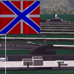
Rybachiy Nuclear Submarine Base, NATO reporting name "The Hornet's Nest." This scenery is specific to the Aerosoft addon "Kamchatka - the Lost Continent." You are welcome to use it, regardless, but in testing, only half the peninsula showed with the Aerosoft scenery inactive.
Rybachiy has a long and chequered past as the home of the Soviet Pacific submarine fleet. It launched the ill fated K-129 in 1968 and is the final stop for submarines before being "disposed" of, a process that includes either sinking the nuclear core, or interring it indefinitely on a floating platform.
I more or less copied the state depicted in Wikimapia, it shows the docks relatively clear of excess retired subs and 10 or 12 Grumble launchers at the SAM site, which is no longer the case. I wonder who's buying up the retired SA-10's..
The odd looking torpedo on the loading dock is the 240 mph, super-cavitating VA-111 Shkval, which is essentially a rocket engined defensive weapon. A consequence of the presumed and persistent superiority of Western underwater acoustics, it is understood that the enemy would "get the drop." In such a circumstance, the crew would load a Shkval and fire it in the direction of the approaching torpedo, which would force the attacking sub to sever the control wire to avoid being hit.
Elsewhere, at the SLBM dock, you can see the R-29 Vysota being loaded. It is being advertized as a launch platform for low orbit satellites, besides MIRV's, of course. The SLBM dock is removed from the main base. Steer north of west from the docks, or use Wikimapia to find it.
This is an edit and enhancement of a scenery addon already published by Blaunarwal. He did an excellent job adding detail to Yelizovo, Petropavlovsk-Kamchatsky and Avachinskiy Bay. I contacted him and asked if he would collaborate and edit his AI boat traffic to match the docks I moved and he graciously agreed. I tried to arrange the files so it would be equally easy to install to the previous version or as an original.
| Filename: | Rybachiy_Submarine_Base_The_Hornets_Nest.zip |
| License: | Freeware, limited distribution |
| Added: | 18th August 2013, 19:32:26 |
| Downloads: | 779 |
| Author: | Rick Keller |
| Size: | 198.88 MB |
| Category: Flight Simulator X - Scenery | |
| Polikastro Nea Kavala Airport |
|
Images related to this file:
File Description:
Polikastro (Nea Kavala) is a general aviation airport in North Greece only for VFR flights by day. The scenery features:
- custom runway lines.
- custom 3d grass.
- custom buildings.
- photoscenery resolution 18cm.
- some custom objects..
It's for FSX - P3D v2 - P3D v3.
| Filename: | Polikastro_Nea_Kavala_Airport.zip |
| License: | Freeware |
| Added: | 5th January 2016, 11:13:25 |
| Downloads: | 698 |
| Author: | Andreas Alexakis |
| Size: | 33.9 MB |
| Category: Flight Simulator X - Scenery | |
| ENHV - Honningsvag-Valan - Honningsvag, Norway |
|
Images related to this file:
File Description:
ENHV is the most northern airport in Europe (self-promotion of the airport). It it situated on a promontory 46 feet above the sea a few miles southeast of the Nordkap.
This scenery is not a stand-alone-scenery. It is an update of the Airports of Norway (AoN) where ENHV is already included. So AoN has to be installed first to see the buildings and the objects on this airport.
In addition the Nordkap is included with the rock, the museum and the viewing point.
AON you can download here:
http://www.flightsimnorway.com/addons/default.php?funct=dl&pack=aon
Also recommended is to install are the corresponding Photo sceneries AoN Phatopack 1 + 2:
http://www.flightsimnorway.com/addons/default.php?funct=dl&pack=aon
There are some errors corrected In ENHV that occur in the AoN:
1. The altitude is adjusted to the correct height of 46 feet.
2. The sea is where it should be.
3. The land classes are partially adjusted.
4. The town of Honningsvag is involved.
5. The Northern Cape is included, but can be installed separately.
| Filename: | ENHV__HonningsvagValan__Honningsvag_Norway.zip |
| License: | Freeware |
| Added: | 19th October 2015, 18:54:47 |
| Downloads: | 1,920 |
| Author: | Wolfgang Allers |
| Size: | 131.64 MB |
| Category: Flight Simulator X - Scenery | |
| EETN - Tallinn, Estonia v3.5 |
|
Images related to this file:
File Description:
This software package contains the latest version of Tallinn airport and surrounding obstacles. It is backward compatible with FSX SP2. The scenery was highly optimized to allow all-weather operations. NAV data including SIDs/STARs, waypoints and RNAV routes within Tallinn FIR are up to date (AIRAC effective date 28 MAY 2015). Real NAV charts were helpfully provided by the Estonian ANS (EANS).
Weather Explorer is a stand-alone program requiring Microsoft .NET Framework 4.
| Filename: | EETN__Tallinn_Estonia_v35.zip |
| License: | Freeware |
| Added: | 7th May 2015, 21:56:01 |
| Downloads: | 13,969 |
| Author: | Stas Neznamov |
| Size: | 50.2 MB |
| Category: Flight Simulator X - Scenery | |
| LOWG - Graz, Austria V4.0 |
|
File Description:
LOWG_V4.0 is freeware-version of GRAZ AUSTRIA
Graz is the second greatest Airport in the south of the alps.
1. The building is rebuilt inside and out
2. Parking positions have new textures
3. Run-up was revived and has night textures
4. There are animated vehicles
5. There is much to see along the taxiways
6. 3D - Lighting along the taxiways.
The scenery is at work and should be constantly updated.
| Filename: | LOWG__Graz_Austria_V40.zip |
| License: | Freeware |
| Added: | 16th June 2014, 06:05:46 |
| Downloads: | 3,242 |
| Author: | manfred marbler |
| Size: | 144.5 MB |
| Category: Flight Simulator X - Scenery | |
| Dieuze - Gueblange V2 |
|
Images related to this file:
File Description:
This scenery depicts Dieuze-Gueblange aerodrome located in the north east of France. It is a very accurate rendition of this aerodrome made with photoreal textures for the ground and the objects. The ground is covered with volumetric grass. I have modelled an animated sock that indicates the wind direction and velocity. To see this windsock, Sode (Sim Objects Display Engine) module must be installed (module availabale here : http://sode.12bpilot.ch/?page_id=9). A user manual (pdf) is included.
The windsock library may be used in your own sceneries. If you share a scenery using this library, you must add the BJP_SOCKS folder without any modification in order to avoid duplicate files. Please include my name in any of your included documents. This new release is now compatible with a landclass environment: snowy ground and trees in the hard winter (from the first day of december to the last day of january). Please read the specific enclosed manual.
| Filename: | Dieuze__Gueblange_V2.zip |
| License: | Freeware, limited distribution |
| Added: | 1st February 2015, 23:14:45 |
| Downloads: | 1,451 |
| Author: | Jacques-Paul Bollard |
| Size: | 21.98 MB |
| Category: Flight Simulator X - Scenery | |
| Lebanon TerrainX V1.0 |
|
Images related to this file:
File Description:
Lebanon TerrainX V1.0 by Lebor Simulations brings the landscape of Lebanon in FSX to life. The package improves the elevation, the coastline, the waterclass, the region aspect of the country as well as the landclass and it features most of Lebanon roads with moving traffic. This scenery package along with its future updates, will be a must have before installing any of our future IFR or VFR sceneries.
| Filename: | Lebanon_TerrainX_V10.zip |
| License: | Freeware |
| Added: | 12th April 2010, 22:20:58 |
| Downloads: | 1,863 |
| Author: | Lebor Simulations |
| Size: | 25.78 MB |
| Category: Flight Simulator X - Scenery | |
| Silloth Aerodrome plus Great Orton |
|
File Description:
RAF Station Silloth is a former Royal Air Force station located 1 mile (1.6 km) north-east of Silloth, Cumbria, England and 6.7 miles (10.8 km) south-west of Kirkbride, Cumbria. The station was used by RAF Coastal Command during WW2.
I designed this scenery primarily for my own pleasure using Airport Design Editor and FSX SDK. I use FSX Acceleration and Horizon VFR photo scenery but it should work with standard FSX SP2.
This scenery depicts the airfield as closely as i can get it with the available information. I have modelled all of the Airfield buildings as closely as I could with the information available to me and this was done using Sketchup, the models were then converted for use in FSX using Model converter X.
It is not 100% accurate and no claim is being made by the author that it is. I have depicted the buildings in wartime camo.
All the buildings can be used as as you wish. My only request is that if you should design better textures for them that you let me have a copy, my textures are pretty basic.
Some buildings have night lighting, lights and smoke effects, these should be in your FSX effects files already.
I have not yet completed the Domestic Site but i may do this in the future...(I've hit the buffers for now though!!)
Included in this scenery pack is the Satellite Airfield RAF Great Orton. Built in 1943 to accommodate the larger bombers now being used by the RAF. This airfield is very sparse as i am unable to get much info about it.
Runways, Taxiways, Watch Office and Ground Signals are all that is included in this scenery pack, along with Sloped flattens, crosswind runways and AGN files.
I have included this as a destination for the Bristol Beaufort AI aircraft that i have included with the scenery.
The Bristol Beaufort AI is a freeware model from Alphasim and is used with their permission. I have altered the model textures and aircraft file and it works well enough as AI.
I have used other scenery libraries within this scenery (mainly to depict the village of Silloth) and these will need to be downloaded from the appropriate sources and activated within FSX.
| Filename: | Silloth_Aerodrome_plus_Great_Orton.zip |
| License: | Freeware |
| Added: | 6th December 2015, 22:32:18 |
| Downloads: | 490 |
| Author: | Mark Byers |
| Size: | 357.87 MB |
© 2001-2026 AVSIM Online
All Rights Reserved
Privacy Policy |