
Where Flight Simulation Enthusiasts Gather from Around the World!
AVSIM Library - Search Results

| Category: Flight Simulator X - Scenery | |
| Icabaru (SVIC) & Wonken (SVUQ) - Venezuela |

|
Images related to this file:
File Description:
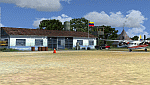
Two small airports located south of Venezuela, especially for VFR flights:
- Icabaru is one of the oldest mining towns in the region located near the border with Brazil.
- Wonken is located in the Canaima National Park, only 15 minutes by plane from Santa Elena de Uairen.
Photo-terrain area improved with Autogen files. Not compatible with versions prior to FSX. Also includes a friendly Auto-Install.
| Filename: | Icabaru_SVIC__Wonken_SVUQ__Venezuela.zip |
| License: | Freeware |
| Added: | 18th January 2014, 16:29:41 |
| Downloads: | 965 |
| Author: | David Maldonado |
| Size: | 83.37 MB |
| Category: Flight Simulator X - Scenery | |
| East Midlands Xtreme |
|
Images related to this file:
File Description:

Extremely accurate scenery for East Midlands airport,UK. Includes night lighting, animation vehicles, replacement AFCAD file, High resolution base image, static and museum aircraft. All textures
made to the highest standard based on actual photographs.
| Filename: | East_Midlands_Xtreme.zip |
| License: | Commercial demo |
| Added: | 10th February 2012, 23:57:06 |
| Downloads: | 2,073 |
| Author: | Gary Summons/UK2000 Scenery |
| Size: | 89.66 MB |
| Category: Flight Simulator X - Scenery | |
| HLTD Ghadames Airport |
|
File Description:
Ghadames Airport (IATA: LTD, ICAO: HLTD) is located 12.1 miles (19.5 km) east of Ghadames, Libya, currently only Libyan Airlines uses the airport as a scheduled service to Tripoli.
Please note that the runways do not have any ilumination service at this time. Daytime service only.
This work is dedicated to West Wind Airlines.
| Filename: | HLTD_Ghadames_Airport.zip |
| License: | Freeware |
| Added: | 26th April 2013, 23:51:48 |
| Downloads: | 542 |
| Author: | Anwar Gonzalez |
| Size: | 215.37 KB |
| Category: Flight Simulator X - Scenery | |
| HLGT - Ghat Airport - Ghat, LIbya |
|
File Description:
Ghat Airport (IATA: GHT, ICAO: HLGT) is located at east of Ghat, Libya, currently only Libyan Airlines uses the airport as a scheduled service to Tripoli.
This work is dedicated to West Wind Airlines.
| Filename: | HLGT__Ghat_Airport__Ghat_LIbya.zip |
| License: | Freeware |
| Added: | 27th April 2013, 19:12:27 |
| Downloads: | 570 |
| Author: | Anwar Gonzalez |
| Size: | 302.47 KB |
| Category: Flight Simulator X - Scenery | |
| LYBE Belgrade Nikola Tesla Airport |
|
File Description:
Belgrade Nikola Tesla Airport (IATA: BEG, ICAO: LYBE) is the primary international airport serving Belgrade, Serbia. Previously known as Belgrade International Airport, it was renamed in 2006 in honour of Serbian-American scientist and
inventor Nikola Tesla.
The airport is situated 12 km (7.5 mi) west, of central Belgrade, in the Surcin Municipality, surrounded by Syrmia's fertile lowlands. Passengers on the right hand side of planes descending from the east have a view of downtown
Belgrade, especially the districts of Cukarica and Novi Beograd. In 2008 the airport installed ILS CAT IIIb equipment to allow aircraft to land and depart in the heaviest of fog, which in past years led to numerous flight diversions
mostly in late December and early January.
The airport is owned and operated by the Public enterprise Aerodrom Nikola Tesla Beograd��. The company recorded profit of 21.5 million euros at the end of 2010.
The national flag carrier and largest airline of Serbia, Jat Airways, uses Belgrade Nikola Tesla as their main hub. It is also one of the hubs for low cost airline Wizz Air. Aviogenex charter airline, and air taxi airlines Air Pink,
Jat Airways AVIO taxi, Prince Aviation and Pelikan Airways also call the airport their home.
The airport charts are included.
This file has the right coordenates, with the apron and characteristics of the airport, airport vehicules and buildings, please take note the the gates numbers needed to changed: C1A= C11, C3A=C13, C5A=C15; general aviation parking
were added a extra number due to repetion on the numbers.
| Filename: | LYBE_Belgrade_Nikola_Tesla_Airport.zip |
| License: | Freeware |
| Added: | 8th November 2012, 03:32:04 |
| Downloads: | 8,801 |
| Author: | Anwar Gonzalez |
| Size: | 15.17 MB |
| Category: Flight Simulator X - Scenery | |
| SKBO 2011 |
|
File Description:
El Dorado International Airport (IATA: BOG, ICAO: SKBO) is an international airport located in Bogota, Colombia. It is the largest Latin America airport in terms of cargo movements with 593,946 tons (2010) and the third in terms of passenger traffic, only behind Sao Paulo-Guarulhos International Airport and Mexico City's Benito Juarez International Airport, transporting 18,934,203 passengers in 2010; as well as the largest airport in Colombia and the main international and domestic air gateway in the country, serving as an important hub for Avianca, Copa Airlines Colombia, Aires, Satena, EasyFly and other cargo companies.
This file has the right coordinates, with the apron and characteristics of the airport. The runways were reoriented to the correct direction, runway were resized the gates placed on correct location and number, CATAM was placed (Colombian Air force and Colombian National Army) and Colombia National Police and Colombian National Armada were assigned a correct apron. All the jet ways including the ones of the executive terminal are working. There is a copy of all the airport charts required to navigate in and out of this airport which are courtesy of: Areonatica Civil de Colombia
| Filename: | SKBO_2011.zip |
| License: | Freeware |
| Added: | 29th June 2011, 21:16:37 |
| Downloads: | 2,940 |
| Author: | Anwar Gonzalez |
| Size: | 14.34 MB |
| Category: Flight Simulator X - Scenery | |
| SKMZ 2011 |
|
File Description:
La Nubia Airport (IATA: MZL, ICAO: SKMZ) is located in Manizales, Colombia, 8 km[1] southeast of the city's downtown. Due to its short runway and limited ramp space, the only aircraft which can use the airport are turbopropeller
aircraft such as the Fokker 50, ATR 42 and the Dash 8 models. The main problem of La Nubia airport is weather. Sometimes shut down to fog, rain or winds, it is difficult for airlines to offer a reliable schedule for the passengers
wishing to visit Manizales and Caldas, and combined with its limited hours of operation (just daylight), this fact has been an obstacle for the region's development.
This file is the airport with the runway and taxi ways resized, airport buildings; the airport charts required to navigate in and out of this airport can be found at www.aerocivil.gov.co/ under Informacion Aeronautica click AIP;
on AIP click Aerodromos then click at SKMZ.
| Filename: | SKMZ_2011.zip |
| License: | Freeware |
| Added: | 24th August 2011, 00:02:37 |
| Downloads: | 2,090 |
| Author: | Anwar Gonzalez |
| Size: | 4.21 KB |
| Category: Flight Simulator X - Scenery | |
| Gustavo Rojas Pinilla International Airport (SKPS) 2011 |
|
File Description:
Gustavo Rojas Pinilla International Airport (IATA: ADZ, ICAO: SKSP) is the leading airport in the archipelago of San Andres, Providencia and Santa Catalina, which has enough capacity to receive large aircraft, due to a number of
charter flights and seasonal in different parts of America and Europe.
This file has the right coordinates, with the apron and characteristics of the airport. The runways were reoriented to the correct direction, runway were re-sized the gates placed on correct location and number, FAC was placed
(Colombian Air force and Colombian National Army) all the airport charts required to navigate in and out of this airport can be found at www.aerocivil.gov.co/ under Informacion Aeronautica click AIP; on AIP
click Aerodromos then click at SKSP.
| Filename: | Gustavo_Rojas_Pinilla_International_Airport_SKPS_2.zip |
| License: | Freeware |
| Added: | 23rd August 2011, 02:26:49 |
| Downloads: | 1,675 |
| Author: | Anwar Gonzalez |
| Size: | 10.03 KB |
| Category: Flight Simulator X - Scenery | |
| MTCH 2011 |
|
File Description:
Cap-Haitien International Airport (IATA: CAP, ICAO: MTCH) is an airport serving Cap-Haitien, a city in the Nord department in Haiti. It is the second largest airport in Haiti.
This file has the right coordenates, with the apron and characteristics of the airport. The runways were resized the gates placed on correct location and number.
| Filename: | MTCH_2011.zip |
| License: | Freeware |
| Added: | 19th August 2011, 00:30:14 |
| Downloads: | 972 |
| Author: | Anwar Gonzalez |
| Size: | 3.32 KB |
| Category: Flight Simulator X - Scenery | |
| MDMC 2011 |
|
File Description:
MDMC Monte Cristi Airportis an airport of Dominican Republic.
| Filename: | MDMC_2011.zip |
| License: | Freeware |
| Added: | 20th August 2011, 02:30:26 |
| Downloads: | 756 |
| Author: | Anwar Gonzalez |
| Size: | 2.78 KB |
© 2001-2026 AVSIM Online
All Rights Reserved
Privacy Policy |