
Where Flight Simulation Enthusiasts Gather from Around the World!
AVSIM Library - Search Results

| Category: Flight Simulator X - Scenery | |
| Larisa |

|
Images related to this file:
File Description:
Larisa/Volos
AS REAL AS IT GETS.
This is a detailed photorealistic scenery of Larisa, Volos and the area from
Anatolikos Olympos in the North to Almyros in the South WITH NIGHT TEXTURES.
| Filename: | Larisa.zip |
| License: | Freeware |
| Added: | 28th May 2016, 21:12:16 |
| Downloads: | 911 |
| Author: | Angelo Tassoglou |
| Size: | 204.01 MB |
| Category: Flight Simulator X - Scenery | |
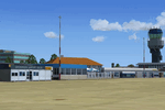
| St. Kitts Island - Federation of Saint Kitts and Nevis |
|
Images related to this file:
File Description:
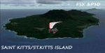
A representation of St. Kitts using photo-real scenery along with hand placed autogen. Robert L. Bradshaw International Airport is an international airport located just northeast of Basseterre, on the island of Saint Kitts, serving the nation of Saint Kitts and Nevis.
New construction started late 2004. Up to 6 wide bodied jets can now be accommodated on the tarmac. The airport can accommodate commercial jumbo jets and handles scheduled non-stop jet flights to Canada and the United States, as well as numerous regional commuter flights from within the Caribbean area. For the best results of this scenery, PWSceneries Volume 5 has to be installed. Features included are custom photo scenery covering the entire island, hand placed autogen, detailed 3D Objects and custom buildings. Works in FSX and P3D.
| Filename: | St_Kitts_Island___Federation_of_Saint_Kitts_and_Ne.zip |
| License: | Freeware |
| Added: | 24th September 2015, 10:57:42 |
| Downloads: | 827 |
| Author: | Kenje Thomas & Jamalje Bassue |
| Size: | 105.56 MB |
| Category: Flight Simulator X - Scenery | |
| Kavala - Greece |
|
Images related to this file:
File Description:
Kavala DN
AS REAL AS IT GETS.
This is a highly detailed photorealistic scenery of the beautiful Kavala area
and the Island of Thasos WITH NIGHT TEXTURES.
The scenery contains many objects like cars, boats and buldings in many cities
like Kavala, Keramoti, Thasos and around the airport.
Default FSX airport Megas Alexandros (LGKV) and Amigdhaleon (LGKM) were
corrected and repositioned to their exact location, runway 05L was added,
many buildings and trees, aircraft hangers, airforce static aircraft and army vehicles.
Also I added 2 small aircraft traffic files and a small file for helicopter traffic.
Check the Oil Rig in Kavala Bay and try to land on the helipad.
The scenery also includes the customary autogen buildings, vegetation and
road traffic near the cities to enhance and animate the landscape.
| Filename: | Kavala__Greece.zip |
| License: | Freeware |
| Added: | 24th November 2016, 17:35:13 |
| Downloads: | 1,466 |
| Author: | Angelo Tassoglou |
| Size: | 200.36 MB |
| Category: Flight Simulator X - Scenery | |
| Ghat HLGT Libya |
|
Images related to this file:
File Description:
Ghat is a medium-sized airport located in the south-west of Libya, near Algerian border, and 10 miles north of the city of Ghat. In early 2010s Ghat was undergoing major renovatios, but civil war in Libya has put these plans on hold. While all runways and taxiways were recently repaved, new passenger terminal is still unfinished, and air traffic is almost non-existent. Except from military and cargo planes, the only regular passenger flight to Ghat nowadays is Air Libyan from Tripoli: their A320 is visiting this place twice a week. This scenery has super-accurate layout, precise marking, and correct navaids according to the latest satellite images and charts. Photo background blends perfectly with ORBX Global. Unfinished new terminal with the construction site. Taxi signs were added for convenience. Enhanced city of Ghat and surrounding landclass. Made for P3Dv3, tested on P3Dv4 and FSX:SE. Made by Dmitriy Kozyrev.
| Filename: | Ghat_HLGT_Libya.zip |
| License: | Freeware |
| Added: | 27th September 2017, 06:18:00 |
| Downloads: | 1,223 |
| Author: | Dmitriy Kozyrev |
| Size: | 31.43 MB |
| Category: Flight Simulator X - Scenery | |
| hythevillage_pier.zip |
|
File Description:
Hythe Village and Pier
Hythe Village [Town] nestles between the edge of Southampton Water and the New Forest, some 500 yards west of the ‘American Base – RAF Hythe’; the surrounding area is known as ‘The Waterside’. Hythe, with its waterfront, boasts incredible views across Southampton Water, while the village [town] centre, with its Georgian High Street, offers a range of shops, services, traffic-free precincts and parking facilities. Nearby is ‘Hythe Marina’, to be found on Southampton Water's southern shore; it’s a unique development of a 206 berth marina, together with waterside homes, shops, restaurants, bars and a boutique hotel.There is also a passenger ferry which sails back-and-forth from Hythe Pier to the City of Southampton every 30 minutes. Before Hythe Pier was built, ferry and other boats arriving at Hythe had to use a gravel hard ramp which ran from the land out to the low tide point in Southampton Water. Walking along the hard gravel was not easy and travellers often got very wet. Various ideas to improve the situation were suggested at the time and construction of Hythe Pier was eventually started in October 1879 and officially opened on the 1st January 1881. Many World War II heroes departed from this pier on D-Day in June 1944.The pier itself stretches some 640 meters into Southampton Water and is one of the ten longest piers in the British Isles. In 1922, a narrow gauge electric railway opened in order to take passengers the full length of the Pier. This railway, with its original engine and rolling stock, is the oldest operating electric pier train in the world and is still operational to this day – playing an important part in the local transportation system between Hythe and Southampton.
Scenery Features
* Bus Shelter
* Ferry Ticket Collectors (On pier landing platform)
* Ferry Ticket Office
* High Street Shops
* Hotspur House
* Hythe Library & Car Park
* Hythe Pier
* Hythe Pier Landing Platform
* Hythe Promenade
* Library Road & Shops
* Lidl Superstore & Car Park
* People (Static & animated)
* Pier Railway & Safety Railings
* Pier Train (Parked at village end of pier)
* Lord Nelson Public House
* Prospect Place Park
* Public Toilets
* Seashells Lounge Bar & Restaurant
* St. John's Church & Cemetery
* Street Lighting
* Streets & Roadways
* ‘The Marsh’ & New Road
* Vegetation (Trees, bushes)
* Vehicles (Buses & cars)
* Waitrose Supermarket & Car Park
* WWII Remembrance Plaque (Prospect Place)
Special Effects
* Animated Birds (seagulls-close to village & pier)
* Chimney Smoke
* Night, Dusk & Dawn Lighting Effects
* Seagull Cry Sounds
| Filename: | hythevillage_pierzip.zip |
| License: | Freeware |
| Added: | 21st November 2025, 12:42:28 |
| Downloads: | 67 |
| Author: | Barrie Semmens |
| Size: | 16.37 MB |
| Category: Flight Simulator X - Scenery | |
| Merrill Field PAMR |
|
Images related to this file:
File Description:
This is a version for FSX of the Merrill Field made by Roger Wensley (me) for FS9, converted by John B Loney jnr. "PAMR read this first" explains this but I have modified John's original procedure, and instead of first installing the Merrill Field original plus two updates I have included here the current FS9 version as installed on my computer. Note that to see the apron lighting working in FS9 it was necessary to have Sidney Schwartz's light library installed, along with his updated textures (to avoid severe blurries caused by a faulty texture). The original installation instructions are included giving file library priorities etc. Just ignore the bits that do not apply, such as installing AI that is not included. I have of course omitted the original AI as this is replaced by John's version. I have no comment to make on installing in FSX as I have not done so, and I have not tested it in FSX. If you have comments or questions I will respond as much as I am able. Merrill Field is in Anchorage Alaska, between Anchorage International to the southwest and and Elmendorf Air Force Base to the north. It caters for general aviation and is the land equivalent of the Lake Hood float plane base, with fuel and numerous maintenance facilities, and several hundred parking spots for small planes. There are three runways, and the longest is 4,000 feet of 100 feet wide asphalt, the second 2,635 feet of asphalt 75 feet wide, and the third 2,000 feet of 60 feet wide gravel. The first two have runway lights. It is a controlled airfield with a relatively new control tower to cater for the numerous flights and to coordinate with Elmensdorf and Anchorage International, the latter also controlling flights from Lake Hood and the adjacent gravel strip Z41. (See my Lake Hood scenery). The gravel runway at Merrill Field is not connected with active taxiways to the rest of the airfield; this avoids you being ordered to land on it when flying a plane too large to do so.
| Filename: | Merrill_Field_PAMR.zip |
| License: | Freeware, limited distribution |
| Added: | 3rd July 2017, 18:00:19 |
| Downloads: | 451 |
| Author: | Roger Wensley and John B loney jnr |
| Size: | 21.73 MB |
| Category: Flight Simulator X - Scenery | |
| Whale Island (Hi Resolution Photo and mesh), New Zealand |
|
Images related to this file:
File Description:
Whale Island (Maori Name: Moutohora) is a small island located off the Bay of Plenty coast of New Zealand's North Island. It is located about 12 kilometers north of the town of Whakatane. A whaling station existed on the island during the 19th century. The 1.43 km island is a remnant of a complex volcano which has eroded, leaving two peaks. This is still an area of volcanic activity and there are hot springs on the island in Sulphur Valley, McEwans Bay, and Sulphur Bay.
This Hi Resolution scenery was created from a 0.25m pixel resolution Ortho-rectified Aerial mosaic owned by Environment Bay of Plenty (The Bay of Plenty Regional Council) and flown in 2007. The imagery has been slightly de-sampled for use in Flight Simulator X and utilizes the a custom hi resolution 5m Mesh derived from photogrammetry data off the photos. The textures are intended for summer daylight flying only, although due to the evergreen nature of New Zealand's native bush, the Islands appearance remains relatively constant throughout the year.
The island contains a small helicopter pad which is used for checking the various radio antennas on the Island. There is also a small Department of Conservation hut near the south western tip of the Island. These objects have been added from the FSX library of objects. Make sure to turn up your graphics sliders to make the most of this data! To find the Island fly north from Whakatane airport.
| Filename: | Whale_Island_Hi_Resolution_Photo_and_mesh_New_Zeal.zip |
| License: | Freeware, limited distribution |
| Added: | 20th January 2010, 10:12:14 |
| Downloads: | 4,650 |
| Author: | Tim Barnes |
| Size: | 9.94 MB |
| Category: Flight Simulator X - Scenery | |
| Netherlands NL2000 v4.0 Libraries package |
|
Images related to this file:
File Description:

This is the NL2000 v4.0 libraries package for the NL2000 scenery version 4. Mandatory objects used by most airports of NL2000, including effect files and AI Airplanes. You need the NL2000 v4 installer to install this package. The Netherlands 2000 v4 Scenery is a modular free FSX scenery covering the Netherlands. Visit our website for other available packages. By The Netherlands 2000 Scenery Design Team (www.nl-2000.com).
| Filename: | Netherlands_NL2000_v40_Libraries_package.zip |
| License: | Freeware, limited distribution |
| Added: | 30th May 2010, 11:31:50 |
| Downloads: | 4,400 |
| Author: | The Netherlands 2000 Scenery Design Team |
| Size: | 130.32 MB |
| Category: Flight Simulator X - Scenery | |
| NL2000 V4.02 EHGG Groningen Airport Eelde package |
|
Images related to this file:
File Description:
This is the NL2000 v4.02 EHGG Groningen Airport Eelde package for the NL2000 scenery version 4.
You need the NL2000 v4.0.20 installer to install this package.
The Netherlands 2000 v4 Scenery is a modular free FSX scenery covering the Netherlands.
Visit our website for other available packages.
By The Netherlands 2000 Scenery Design Team (www.nl-2000.com).
| Filename: | NL2000_V402_EHGG_Groningen_Airport_Eelde_package.zip |
| License: | Freeware |
| Added: | 22nd December 2011, 16:57:58 |
| Downloads: | 1,886 |
| Author: | NL2000 scenery design team |
| Size: | 154.94 MB |
| Category: Flight Simulator X - Scenery | |
| NL2000 V4.02 EHEH Eindhoven Airport package |
|
Images related to this file:
File Description:

This is the NL2000 v4.02 EHEH Eindhoven Airport package for the NL2000 scenery version 4.
You need the NL2000 v4.0.20 installer to install this package.
The Netherlands 2000 v4 Scenery is a modular free FSX scenery covering the Netherlands.
Visit our website for other available packages.
By The Netherlands 2000 Scenery Design Team (www.nl-2000.com).
| Filename: | NL2000_V402_EHEH_Eindhoven_Airport_package.zip |
| License: | Freeware |
| Added: | 22nd December 2011, 16:57:46 |
| Downloads: | 2,606 |
| Author: | NL2000 scenery design team |
| Size: | 54.51 MB |
© 2001-2026 AVSIM Online
All Rights Reserved
Privacy Policy |