
Where Flight Simulation Enthusiasts Gather from Around the World!
AVSIM Library - Search Results

| Category: Flight Simulator X - Scenery | |
| KNHZ - NAS Brunswick - Brunswick, ME |

|
Images related to this file:
File Description:

Re-upload. By request, here is an improved version of the stock NAS Brunswick. I added Military_Cargo and Military_Combat parking spaces. I added the fire station and fire trucks. I removed and replaced many default buildings, added additional buildings, and replaced the control tower. Added static fuel trucks, parking lots with cars and light poles. Added, removed, or adjusted taxiways and aprons as needed.
| Filename: | KNHZ__NAS_Brunswick__Brunswick_ME.zip |
| License: | Freeware |
| Added: | 2nd June 2010, 02:00:10 |
| Downloads: | 2,133 |
| Author: | Jim Cook |
| Size: | 12.49 KB |
| Category: Flight Simulator X - Scenery | |
| Cole Landling Area, OK (2OK7) |
|
File Description:
Scenery FSX Cole Landling Area, OK (2OK7)
Newcastle, OK. Small private
strip with residential aircraft parking for residents
and a couple of small businesses. Requires FREE
RWY12 & EZ Scenery libraries available AVSIM.
SEE SPECIAL FSX README INSTRUCTIONS INSIDE
| Filename: | Cole_Landling_Area_OK_2OK7.zip |
| License: | Freeware |
| Added: | 20th October 2006, 04:11:51 |
| Downloads: | 1,223 |
| Author: | Jimmy R. Martin, Paul J Scally |
| Size: | 360.35 KB |
| Category: Flight Simulator X - Scenery | |
| Corpus Christi Intl Aiport, TX (KCRP) |
|
Images related to this file:
File Description:
Corpus Christi, Texas, located on the Gulf of Mexico is a major aviation center with Naval Aviation headquartered here and home to an Army major depot that supports all tri-service rotor wing aircraft. While these activities are based in and around the town there is significant transient military traffic at KCRP along side commercial carrier service by AAL, SWA and UAL to KDFW, KHOU and KIAH. The airport has just completed a major upgrade to both runways (renumbered from default FSX/P3D scenery) and all taxi surfaces. This scenery was constructed with ADEv1.70 targeted for P3D; however, it works as well in FSX. All runway and ILS data has been 'as-built' in accordance with FAA NASD data with extensive use of hand-placed ground polys for taxi markings. I have omitted surrounding landclass modifications for a best fit with Orbx FTX Global OpenLC North America product.
| Filename: | Corpus_Christi_Intl_Aiport_TX_KCRP.zip |
| License: | Freeware |
| Added: | 31st October 2016, 00:39:10 |
| Downloads: | 1,521 |
| Author: | Dan Downs |
| Size: | 674.06 KB |
| Category: Flight Simulator X - Scenery | |
| St Tammany Regional Airport - L31 |
|
File Description:
St. Tammany Regional Airport (FAA LID: L31) is a public use airport in St. Tammany Parish, Louisiana, United States. It is owned by St. Tammany Parish and located six nautical miles (11 km) southeast of the central business district of Covington, Louisiana. The nearest town is Abita Springs.
| Filename: | St_Tammany_Regional_Airport__L31.zip |
| License: | Freeware |
| Added: | 1st December 2013, 21:25:48 |
| Downloads: | 306 |
| Author: | Rob Meier |
| Size: | 2.48 MB |
| Category: Flight Simulator X - Scenery | |
| Galway Airport - EICM |
|
File Description:
Galway FSX.
FSX compatible only.
Includes: Updated Parking, Scenery objects, Terminal, Fire station, South apron, Galway flying club and more.
Created using ADEX v01.47.07
Created from default scenery.
| Filename: | Galway_Airport__EICM.zip |
| License: | Freeware |
| Added: | 17th February 2011, 20:44:09 |
| Downloads: | 802 |
| Author: | Padraic O hEithir |
| Size: | 3.94 MB |
| Category: Flight Simulator X - Scenery | |
| Cork Airport |
|
File Description:
Cork FSX
Includes: South Apron, T2 with jetway to gate 10, Holding short positions on runway 7/25, New tower and Updated parking positions on main apron.
| Filename: | Cork_Airport.zip |
| License: | Freeware |
| Added: | 7th September 2010, 20:13:15 |
| Downloads: | 833 |
| Author: | Padraic O hEithir |
| Size: | 2.96 MB |
| Category: Flight Simulator X - Scenery | |
| Pagasa Island, Philippines |
|
Images related to this file:
File Description:
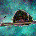
Pagasa Island is a jewel in the South China Sea. It is the one pictured - an emerald splash in an azure sea slashed by a coral runway - whenever new collisions or confrontations are reported in the news for the region. Occupied continuously by the Philippines since 1971, historical use dates back to the Han dynasty, which many believe forms the basis of the Chinese claim to the island. Each country has it's own interpretation of international law and the Filipinos are clearly banking on the precedence of continuous occupation, at no small expense, as Rancudo Field is the farthest airport from Manila within the Philippine sphere of control.
Surprisingly, the geography of the island serves to capture and retain rainwater, although the aquifer is stagnant and the water must be treated for consumption. Sea life remains abundant, poachers take coral heads and sea turtles. There is a solar farm and recently installed solar street lights, fuel for the generators is a precious commodity this far from the mainland.
Sadly, nature may solve the struggle for possession by withdrawing the island from the arena. It is believed that the construction of the runway may have compromised the islands basic integrity, allowing it to crumble into the sea. Whatever the cause, the evidence is clear. Bunkers built during the Japanese occupation in WWII are already slipping beneath the waves and the rate of salt water encroachment has been recorded at close to 6" per day.
There are some things to explore, the grounded BRP Laneo Del Norte to the west; over to the north near the resort grounds are a dugout fishing canoe and some authentic Philippine bangka boats; you may want to load up and head east to do some low warning passes over the Chinese fishing fleet. Standing at the east end of the field, you can just barely spot the China Coast Guard cutter's smoke on the horizon.
The tower is marked by a bright strobe that fires once every five seconds and at night it is bright enough to guide you back to the island from the distance of the fleet. There are no published procedures and the tower is not staffed. Airport ICAO is RPPN.
| Filename: | Pagasa_Island_Philippines.zip |
| License: | Freeware, limited distribution |
| Added: | 10th May 2014, 12:21:19 |
| Downloads: | 1,851 |
| Author: | Rick Keller |
| Size: | 16.17 MB |
| Category: Flight Simulator X - Scenery | |
| Los Roques Archipelago and Airports |
|
Images related to this file:
File Description:
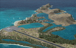
This project rebuilds Venezuela's Los Roques archipelago, adds the Gran Roque (SVRS) and Dos Mosquises (SVDM) airports, and includes AI flight plans, boat traffic, and a custom terrain mesh for Gran Roque. Accurate coastlines and lakes, as well as corrected landclass and waterclass are provided based on the latest available satellite imagery. Although current satellite imagery for this region only exists in relatively low resolution, an abundance of aerial photography was used to add custom features to Gran Roque and Dos Mosquises. Updates were created or rebuilt in a manner which carefully aligned airport data with current satellite imagery, when available. Scenery was created using Airport Design Editor X v1.50.4402, SBuilderX 3.13, and the FSX Object Placement Tool. Scenery objects were added and modified from stock FSX scenery to resemble as closely as possible the actual airports. Thank you to John Hinson and Tiago Besciak for granting permission to adapt their AI flight plans to realistically populate (SVRS) Gran Roque.
| Filename: | Los_Roques_Archipelago_and_Airports.zip |
| License: | Freeware |
| Added: | 27th July 2013, 02:34:10 |
| Downloads: | 1,387 |
| Author: | Carlyle Sharpe |
| Size: | 7.66 MB |
| Category: Flight Simulator X - Scenery | |
| China Burma India Malaya and N.E.I. WWII airfields |
|
File Description:
Allied WWII airfields in India, Burma, China, Malaya and the N.E.I. Bibliography, Maps and Diagrams.
Expands and replaces previous CBIX.zip version.
| Filename: | China_Burma_India_Malaya_and_NEI_WWII_airfields.zip |
| License: | Freeware |
| Added: | 26th March 2011, 23:08:21 |
| Downloads: | 868 |
| Author: | Alex D. Nicolson |
| Size: | 47.1 MB |
| Category: Flight Simulator X - Scenery | |
| Tonopah Test Range - TNX |
|
File Description:
This file contains several BGL's which enhance the default FSX Tonopah Test Range (TNX).
Parking, scenery objects, and roads are added to the bland stock airport.
The "mesa" created by the stock airport backgound flatten is blended into the
surrounding terrain using "sloped flattens". The surrounding "city" was removed
and a better landclass substituted.
This scenery is not intended to re-create a perfect match to the real world but
to enhance the visual experience of flying into and out of the airport.
The files were tested with FSX-Acceleration\SP2 on WinXP Pro, DX9.
I used 10M mesh from the "FSX Usa 10 M terrains Project" when blending
| Filename: | Tonopah_Test_Range__TNX.zip |
| License: | Freeware |
| Added: | 21st December 2007, 04:35:03 |
| Downloads: | 1,236 |
| Author: | Paul Strogen |
| Size: | 843.73 KB |
© 2001-2026 AVSIM Online
All Rights Reserved
Privacy Policy |