
Where Flight Simulation Enthusiasts Gather from Around the World!
AVSIM Library - Search Results

| Category: Flight Simulator X - Scenery | |
| CYHE - Hope |

|
File Description:
This airfield is home to the Vancouver Soaring Association, a gliding club owning and operating seven school and recreational sailplanes and two Cessna L-19 Bird Dog as tow planes.
Enjoy a challenging VFR Approach in the valley, but again, avoid nightime since the airfield has no illuminated strip! ;)
I have included a dirt parking spot and of course the gliders and more...
Hope you'll enjoy the scenery!:)
| Filename: | CYHE__Hope.zip |
| License: | Freeware |
| Added: | 10th March 2009, 16:38:12 |
| Downloads: | 1,447 |
| Author: | Daniel Louvet |
| Size: | 191.17 KB |
| Category: Flight Simulator X - Scenery | |
| Castlegar Airport (CYCG) |
|
File Description:
Patch for Vern Opperman's FS2004 Castlegar Airport scenery to make it
work in FSX
| Filename: | Castlegar_Airport_CYCG.zip |
| License: | Freeware |
| Added: | 11th April 2009, 06:34:35 |
| Downloads: | 928 |
| Author: | P Nigel Grant/Vern Opperman |
| Size: | 1.14 MB |
| Category: Flight Simulator X - Scenery | |
| KASE - Pitkin Airport - Aspen, Colorado |
|
Images related to this file:
File Description:

This is Aspen-Pitkin County Airport/Sardy Field (KASE) for FSX and P3D. This scenery was created using ADE9X, SBuilderX, and Instant Scenery 2, and includes accurate aprons, taxiways, and runway as of 2013. Building placement is also accurate, and all building models were taken from existing 3rd party object libraries. I hope you enjoy the scenery!
| Filename: | KASE__Pitkin_Airport__Aspen_Colorado.zip |
| License: | Freeware |
| Added: | 18th May 2013, 07:45:02 |
| Downloads: | 2,588 |
| Author: | Todd Harrell |
| Size: | 3.55 MB |
| Category: Flight Simulator X - Scenery | |
| Utah Complete (Update 1.2) |
|
File Description:
This update includes AFCAD updates for various airports, adds the new ILS approach to RWY 17 at Logan-Cache Airport (KLGU), adds a new parallel taxiway at Ogden (KOGD), fixes some "building crashes" at Salt Lake City Int'l KSLCfor those with crash detection enabled, and fixes a problem some users have experienced with terrain anomalies at St. George (KSGU) airport. Read the readme file for installation instructions! You must have Utah Complete 1.0 and update 1.1 installed first! You can download these required files here at AVSIM.
| Filename: | Utah_Complete_Update_12.zip |
| License: | Freeware, limited distribution |
| Added: | 22nd November 2007, 12:55:07 |
| Downloads: | 3,535 |
| Author: | James Udall |
| Size: | 211.36 KB |
| Category: Flight Simulator X - Scenery | |
| KDOV - Dover Air Force Base |
|
Images related to this file:
File Description:
FSX Scenery - Dover Air Force Base or Dover AFB (IATA: DOV, ICAO: KDOV, FAA LID: DOV) is a United States Air Force base located two miles southeast of the city of Dover, Delaware. Dover AFB is home to the 436th Airlift Wing (436 AW) of the Air Mobility Command (AMC), known as the "Eagle Wing", and the AMC-gained 512th Airlift Wing (512 AW) of the Air Force Reserve Command (AFRC), referred to as the "Liberty Wing". It was the only base to solely operate the massive C-5 Galaxy, with two active flying squadrons (the 3rd Airlift Squadron, which now operates the C-17 Globemaster III, and 9th Airlift Squadron) and two Air Force Reserve flying squadrons (the 326th Airlift Squadron and the 709th Airlift Squadron). Just drop and fly. Created to enhance your Flight Sim experience by John B. Loney, Jr.
| Filename: | KDOV__Dover_Air_Force_Base.zip |
| License: | Freeware, limited distribution |
| Added: | 15th June 2012, 16:32:10 |
| Downloads: | 2,256 |
| Author: | John B. Loney |
| Size: | 49.59 MB |
| Category: Flight Simulator X - Scenery | |
| Egypt Mesh Scenery SRTM |
|
File Description:
This scenery is based on the collected Datas of the NASA Spaceshuttle mission SRTM
The Shuttle Radar Topographic Mission in the year 2000 made by the Spaceshuttle Endevour.
| Filename: | Egypt_Mesh_Scenery_SRTM.zip |
| License: | Freeware, limited distribution |
| Added: | 2nd January 2012, 16:25:24 |
| Downloads: | 10,996 |
| Author: | Mathias Schindler |
| Size: | 129.51 MB |
| Category: Flight Simulator X - Scenery | |
| LFLJ - Courchevel, France |
|
File Description:
This FSX scenery package contains the LFLJ Courchevel airport in the French Alps. The airport has a very short, upslope runway of only 525 m (1,722 ft). The airport is considered one of the seven most dangerous in the world. It has a difficult approach, a 300 foot upslope runway and is adjacent to the Courchevel ski runs. The Courchevel airport altitude is the highest in Europe, with a mean elevation of 6,520 feet. This airport is intended to be used with FSX and the free addon - TileProxy. TileProxy provides real-time photorealistic satellite imagery in place of the stock auto generated FSX scenery or any other scenery package. The Courchevel airport was originally released as part of an FSX airport scenery package containing 15 airports, located in the French Alps. The link to the original 15 French Alps Airport package is shown below. This file is not required, but allows you to download 15 related French Alps airports. The LFLJ, Courchevel airport in the original 15 airport package was missing a required scenery file which corrects the airport altitude (from 6420 ft. to 6520 ft.) due to the mis-location of the stock FSX airport. This download provides all three of the required .bgl scenery files.
related download:
http://library.avsim.net/search.php?SearchTerm=french+alps+airports&CatID=root&Go=Search
| Filename: | LFLJ__Courchevel_France.zip |
| License: | Freeware |
| Added: | 30th November 2013, 20:20:07 |
| Downloads: | 6,039 |
| Author: | John Greenwood |
| Size: | 655.63 KB |
| Category: Flight Simulator X - Scenery | |
| KTTN - Trenton - Mercer Airport - New Jersey, USA |
|
Images related to this file:
File Description:
East Coast Simulations presents Trenton Mercer Airport Scenery for FSX/P3D! Trenton - Mercer Airport (IATA: TTN, ICAO: KTTN, FAA LID: TTN), sometimes also referred to as Trenton Mercer Airport, is a county-owned, joint civil military, public airport located four miles northwest of Trenton in the West Trenton section of Ewing Township, Mercer County, New Jersey. Formerly known as Mercer County Airport, the airport serves one scheduled airline plus general and corporate aviation. As reported in early 2014, about 325,000 passengers use the airport each year. This detailed scenery includes several custom buildings, a photoreal background for all seasons and custom ground polygons. This is the first release for East Coast Simulations, and more will be coming soon.
| Filename: | KTTN__Trenton__Mercer_Airport__New_Jersey_USA.zip |
| License: | Freeware |
| Added: | 30th June 2015, 23:45:58 |
| Downloads: | 1,111 |
| Author: | Wesley Chin and Kyle Kato |
| Size: | 91.41 MB |
| Category: Flight Simulator X - Scenery | |
| SBSV - Salvador Fotoreal |
|
File Description:
This is a Salvador Photoreal made in Luis Sa's Sbuilder X.
| Filename: | SBSV__Salvador_Fotoreal.zip |
| License: | Freeware |
| Added: | 8th August 2008, 00:48:25 |
| Downloads: | 4,033 |
| Author: | Alexandre Vieira |
| Size: | 57.67 MB |
| Category: Flight Simulator X - Scenery | |
| FSX National Museum of the U.S. Air Force Scenery Package |
|
Images related to this file:
File Description:
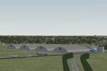
FSX National Museum of the U.S. Air Force Scenery Package
Custom built hangars and buildings on the old Wright Field (closed)for the National Museum of the Air Force (formerly US Air Force Museum), Dayton, Ohio. Near the south end of Wright-Patterson AFB runways. Great for VFR flyers. EZ scenery, Dan French Core LibrariesVol4_FSX or higher, and some others required (see readme). By Dan French.
| Filename: | FSX_National_Museum_of_the_US_Air_Force_Scenery_Pa.zip |
| License: | Freeware |
| Added: | 16th July 2020, 23:15:30 |
| Downloads: | 227 |
| Author: | Dan French |
| Size: | 266.55 KB |
© 2001-2026 AVSIM Online
All Rights Reserved
Privacy Policy |