
Where Flight Simulation Enthusiasts Gather from Around the World!
AVSIM Library - Search Results

| Category: Flight Simulator X - Scenery | |
| Australian Offshore Oil & Gas Platforms |

|
Images related to this file:
File Description:

60 helicopter or VTOL land-able Oil rigs that are in current operation around Australia in 2016. Each Rig is GPS mapped for the in-sim GPS/flight planning and 3rd party nav/flight planning software ie: Flightsim Commander or Plan G. Majority of the Rigs contain wildlife around the platform. Google Earth KML include. Zip file contains exculdes to remove the oil pumps supplied by FTX for their AU release and instructions on how to deactivate the older rig locations in OZx v >3. Visit Ozx for more Australasian scenery. Tested in P3D.
| Filename: | Australian_Offshore_Oil__Gas_Platforms.zip |
| License: | Freeware |
| Added: | 19th February 2016, 09:21:57 |
| Downloads: | 797 |
| Author: | Matt Levi |
| Size: | 187.22 KB |
| Category: Flight Simulator X - Scenery | |
| Christchurch Airport (NZCH) Control Tower |
|
File Description:
Christchurch Airport (NZCH) Control Tower v 1.0 for FSX/P3D - FREEWARE ONLY.
Scenery of the Christchurch airport control tower which opened in 2009. Features high quality 2048 textures and a nice night effect. Works great with Orbx NZSI.
The file contains everything you need. Simply unzip, add to your scenery library and enjoy!
| Filename: | Christchurch_Airport_NZCH_Control_Tower.zip |
| License: | Freeware |
| Added: | 19th February 2016, 23:05:13 |
| Downloads: | 850 |
| Author: | Jack Cheng |
| Size: | 5.02 MB |
| Category: Flight Simulator X - Scenery | |
| German Airfields Northeast Vol3 |
|
File Description:
Airfields in Northeast of Germany with correct postion and some standard and RWY12 objects.
EDAE, EDAL, EDAP, EDAT, EDAW, EDAX, EDBG, EDBR, EDBV, EDBW, EDBY, EDBZ, EDCE, EDCI, EDCL,
EDCR, EDCX, EDON, EDUA, EDUS.
| Filename: | German_Airfields_Northeast_Vol3.zip |
| License: | Freeware |
| Added: | 22nd February 2016, 18:54:14 |
| Downloads: | 1,194 |
| Author: | Juergen Wolf |
| Size: | 209.75 KB |
| Category: Flight Simulator X - Scenery | |
| German Airfields Northwest Vol3 |
|
File Description:
Airfields in Northwest of Germany with correct postion and some standard and RWY12 objects.
EDEM, EDFG, EDFI, EDFQ, EDFT, EDGA, EDGF, EDGK, EDGN, EDGQ, EDGR, EDGT, EDHC, EDHU, EDHS,
EDKN, EDKW, EDLK, EDLR, EDLX, EDRV, EDRW, EDVA, EDVC, EDVG, EDVP, EDWM, EDWU, EDWX, EDXI,
EDXL, EDXU, EDXZ.
| Filename: | German_Airfields_Northwest_Vol3.zip |
| License: | Freeware |
| Added: | 22nd February 2016, 18:54:21 |
| Downloads: | 1,740 |
| Author: | Juergen Wolf |
| Size: | 246.05 KB |
| Category: Flight Simulator X - Scenery | |
| German Airfields Southeast Vol3 |
|
File Description:
Airfields in southeast of Germany with correct position and some standard and Rwy12 objects.
EDMD, EDMN, EDMU, EDMW, EDMY, EDNA, EDNB, EDNE, EDNM, EDPF, EDPJ, EDPK, EDPW
| Filename: | German_Airfields_Southeast_Vol3.zip |
| License: | Freeware |
| Added: | 22nd February 2016, 18:55:45 |
| Downloads: | 1,130 |
| Author: | Juergen Wolf |
| Size: | 226.07 KB |
| Category: Flight Simulator X - Scenery | |
| RAF Driffield |
|
File Description:
The site was first opened in 1918 by the Royal Air Force (RAF) under the name of RAF Eastburn, before closing in early 1920. However, in 1935 a new airfield was built for the RAF initially training bomber crews before closing in 1977 when the site was turned over to the Army for use as a driving school being renamed Alamein Barracks.
The army used Driffield as a driver training centre, until RAF Leconfield (which was also taken over by the Army in 1977) was enlarged to accommodate those who lived and trained at Driffield. In 1992, the RAF regained ownership of this historic aerodrome, naming it: RAF Staxton Wold – Driffield Site. Once again, the RAF ensign flew over Driffield, but not for long. In 1996, the RAF itself transferred its own personnel and facilities to RAF Staxton Wold, thus bringing an end to 60 years of service. On 28 June 1996, the RAF ensign was lowered for the last time, bringing to an end RAF Driffield. It is used as a CTC (cadet training centre) for army cadets and houses 873 Driffield Squadron air training corps
For a more detail history of this station follow the link: https://en.wikipedia.org/wiki/RAF_Driffield
| Filename: | RAF_Driffield.zip |
| License: | Freeware |
| Added: | 22nd February 2016, 18:56:29 |
| Downloads: | 346 |
| Author: | Terry Boissel |
| Size: | 1.35 MB |
| Category: Flight Simulator X - Scenery | |
| CYEG - Edmonton Intl - Alberta, Canada *UPDATE* |
|
Images related to this file:
File Description:
This airport update is for CYEG with two optional files made only for FSX: one version with the Crosswind runway activated and in full operation where both runways will be used for takeoff/landing and one version as the default runway operation: assigned parking updated as per their website with extra parking including a gate for the A380, Canadian North are using their Executive Flight Centre T3 for some arrivals and departures, the new control tower added, taxiways and taxi signs updated to the latest charts, extra fuel trucks, support vehicle roads rebuilt and many other scenery improvements, airport views are from inside the new control tower (when in tower view) please view the readme before installation.
| Filename: | CYEG__Edmonton_Intl__Alberta_Canada_UPDATE.zip |
| License: | Freeware, limited distribution |
| Added: | 23rd February 2016, 22:01:06 |
| Downloads: | 21,387 |
| Author: | Ray Smith and Craig Scott |
| Size: | 2.52 MB |
| Category: Flight Simulator X - Scenery | |
| Update for German Airfields |
|
File Description:
Update for the following airfields:
EDAR, EDCO, EDEG, EDGE, EDOH, EDOS, EDQS, EDTR.
| Filename: | Update_for_German_Airfields.zip |
| License: | Freeware |
| Added: | 26th February 2016, 18:37:28 |
| Downloads: | 759 |
| Author: | Juergen Wolf |
| Size: | 22.25 KB |
| Category: Flight Simulator X - Scenery | |
| RAF Chalgrove - Oxfordshire ,England |
|
File Description:
Chalgrove Airfield (ICAO: EGLJ) is a former Second World War airfield in Oxfordshire, England. The airfield is located approximately 3 mi (4.8 km) north-northeast of Benson; about 42 mi (68 km) north-northwest of London.
Opened in 1943, it was used by both the Royal Air Force and United States Army Air Forces. During the war it was used primarily as a combat reconnaissance airfield. It was closed in late 1946 and today, the airfield is primarily used by the Martin-Baker company for testing ejector seats. Source: Wikipedia.
| Filename: | RAF_Chalgrove__Oxfordshire_England.zip |
| License: | Freeware |
| Added: | 27th February 2016, 21:52:35 |
| Downloads: | 327 |
| Author: | Terry Boissel |
| Size: | 1.96 MB |
| Category: Flight Simulator X - Scenery | |
| Greece - Chalkidiki Kassandra Photoreal |
|
Images related to this file:
File Description:
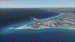
LOD15 photoreal scenery of Kassandra peninsula (a.k.a. first "leg"),part of Chalkidiki peninsula which is one of the greatest Summer destination for locals and foreigners alike.Night textures are also included although without any lighting,however works flawlessly with "Greece Night Environment" by Aerosoft). No airports or airfields or landing strips to land, however you can use float planes to go to the beaches.Nearest airport LGTS Thessaloniki Macedonia INTRNL airport.
The scenery has been designed for, and tested with FSX only. Full installation instructions, settings, hints and tips are included. Please enjoy and I hope you like my scenery as much as I enjoyed building it.
| Filename: | Greece__Chalkidiki_Kassandra_Photoreal.zip |
| License: | Freeware |
| Added: | 1st March 2016, 22:13:47 |
| Downloads: | 968 |
| Author: | Nick Konstantoulas |
| Size: | 150.86 MB |


© 2001-2026 AVSIM Online
All Rights Reserved
Privacy Policy |