
Where Flight Simulation Enthusiasts Gather from Around the World!
AVSIM Library - Search Results

| Category: Flight Simulator X - Scenery | |
| CANMeshX - CAN_87 |

|
Images related to this file:
File Description:
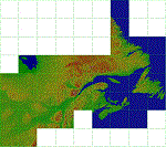
This is a LOD 5 (1216.05m per pixel) to LOD 11 (19m per pixel) terrain mesh scenery file. This terrain mesh is a work in progress, it was started more than two years ago and was never finished. While the files uploaded here have been checked thoroughly there may be errors. If you find any obvious errors please do let me know by email, my intention is to eventually finish this project as the difference in the before and after is astounding especially in areas where I have also included new coastlines. This mesh does cover some border areas of the United States of America too and eventually my intentions are to provide the same product coverage there including higher LOD levels where data is available. This is 1 of 40 files currently available.
| Filename: | CANMeshX__CAN_87.zip |
| License: | Freeware, limited distribution |
| Added: | 9th November 2015, 17:49:57 |
| Downloads: | 177 |
| Author: | Ben Clark |
| Size: | 136.08 MB |
| Category: Flight Simulator X - Scenery | |
| RAF Topcliffe - Yorkshire, England |
|
File Description:
RAF Topcliffe (ICAO: EGXZ) is a Royal Air Force station in North Yorkshire, England. It is a satellite station serving in the role of a Relief Landing Ground for Tucano aircraft of the Central Flying School (CFS) based nearby at RAF Linton-on-Ouse (one of two, the other being Dishforth Airfield). As such, no RAF personnel are based permanently at the airfield and airfield services are provided by personnel assigned to RAF Linton-on-Ouse.
Topcliffe is also used by the Air Training Corps as a motor glider airfield for Gliding induction courses and Gliding scholarships.
| Filename: | RAF_Topcliffe__Yorkshire_England.zip |
| License: | Freeware |
| Added: | 1st January 2016, 17:50:08 |
| Downloads: | 404 |
| Author: | Terry Boissel |
| Size: | 1.34 MB |
| Category: Flight Simulator X - Scenery | |
| RAF Langham - Norwich, Norfolk, England |
|
File Description:
RAF Langham is a former Royal Air Force station, located 15 miles (24 km) North-West of Norwich, Norfolk, England, from 1940 to 1961. The airfield was the most northerly of the Norfolk wartime RAF airfields and was situated 3.3 miles (5.3 km) from the North sea at Blakeney. This made it a desirable location to be used by Coastal Command which had come into prominence since the outbreak of the Second World War. Originally the base was built as a dispersal and satellite station to RAF Bircham Newton during the first few months of the war and it became operational in the summer of 1940. Third party add-on will be needed - see the included read-me.
| Filename: | RAF_Langham__Norwich_Norfolk_England.zip |
| License: | Freeware |
| Added: | 4th January 2016, 16:20:02 |
| Downloads: | 211 |
| Author: | Terry Boissel |
| Size: | 1.41 MB |
| Category: Flight Simulator X - Scenery | |
| RAF Attlebridge - Norwich, Norfolk, England |
|
File Description:
RAF Attlebridge is a former Royal Air Force station located near Attlebridge and 8 miles (13 km) northwest of Norwich, Norfolk, England. RAF Attlebridge was an early wartime station, laid out for use by No. 2 Group RAF light bombers, and was completed in August 1942. The airfield was used by No. 88 Squadron RAF from August 1941 to September 1942 using Bristol Blenheim IVs and Douglas Bostons.
The Station had runways of 1,220, 1,120 and 1,080 yards length but, when the base was earmarked for USAAF use, these were extended and the airfield was enlarged to meet heavy bomber requirements. The main E-W runway was increased to 2,000 yards and the others to 1,400 yards each. The perimeter track was also extended and the number of hardstands was increased to fifty. In enlarging the airfield, several small, country roads were closed in the parish of Weston Longville, in which the larger part of the airfield was sited.
RAF Attlebridge was assigned to the United States Army Air Forces (USAAF) Eighth Air Force's 2nd Bomb Wing on 30 September 1942. It was given USAAF designation Station 120.
Third party add-on scenery will be required - see readme for details.
| Filename: | RAF_Attlebridge___Norwich_Norfolk_England.zip |
| License: | Freeware |
| Added: | 4th January 2016, 16:32:15 |
| Downloads: | 329 |
| Author: | Terry Boissel |
| Size: | 1.04 MB |
| Category: Flight Simulator X - Scenery | |
| RAF Peplow - Shropshire, England |
|
File Description:
RAF Peplow (Child Ercall) X3PP is located 7 miles from Market Dayton, the Station started life as RAF Childs Ercall but this was changed to RAF Peplow in August 1943 to avoid confusion with a nearby stations called High Ercall.
The station follows the usual 3 runway pattern of the period, however, the technical site was unusual in that it was located in between 2 runways on the airfield side of the peri-track
There is plenty of information about the units that were stationed at the base available on the internet.
| Filename: | RAF_Peplow__Shropshire_England.zip |
| License: | Freeware |
| Added: | 6th January 2016, 15:19:11 |
| Downloads: | 223 |
| Author: | Terry Boissel |
| Size: | 1.15 MB |
| Category: Flight Simulator X - Scenery | |
| Bellows fictional scenery |
|
Images related to this file:
File Description:
Bellows Fictional scenery with 8 GA Small, 3 GA Medium, 2 GA Large, 2 Cargo, 2 helipads, 3 runway (1 for ultralight), ndb, vor/dme, ils. Builded with ADE. By Jean-Jacques Parel.
| Filename: | Bellows_fictional_scenery.zip |
| License: | Freeware |
| Added: | 9th January 2016, 15:13:22 |
| Downloads: | 131 |
| Author: | Jean-Jacques Parel |
| Size: | 2.36 MB |
| Category: Flight Simulator X - Scenery | |
| RAF Rednal - Shropshire, England |
|
File Description:
Rednal opened as an RAF base on the 8th April 1942. Number 61 Operational Training Unit was located here between the 16th April 1942 and June 1945 under 81 Group Fighter Command. The training unit moved to Rednal from Heston, equipped for the most part with Spitfires.
On June 16 1945, 61 OTU moved to Keevil in Wiltshire. Rednal was no longer wanted and was reduced to Care and Maintenance, then finally sold off in 1962. Rednal Airfield is now owned by the local Mostyn-Owen family and is home to a number of activities, including paint-balling and go-karting, as well of course being the operational base for Rednal Aviation. Source:Aviation North-West
| Filename: | RAF_Rednal__Shropshire_England.zip |
| License: | Freeware |
| Added: | 11th January 2016, 15:12:05 |
| Downloads: | 191 |
| Author: | Terry Boissel |
| Size: | 2.46 MB |
| Category: Flight Simulator X - Scenery | |
| RAF Deopham Green - Norfolk, England |
|
File Description:
RAF Deopham Green is a former Royal Air Force station located near Deopham Green 2 miles (3.2 km) north of Attleborough, Norfolk, England.
| Filename: | RAF_Deopham_Green__Norfolk_England.zip |
| License: | Freeware |
| Added: | 13th January 2016, 22:18:16 |
| Downloads: | 208 |
| Author: | Terry Boissel |
| Size: | 1.18 MB |
| Category: Flight Simulator X - Scenery | |
| RAF Docking - Norfolk, England |
|
File Description:
RAF Docking was a RAF Station of the Second World War a few miles from Bircham Newton in Norfolk.
It was a satellite airfield for the RAF Coastal Command station at RAF Bircham Newton and was mostly used for overflow from there. Opening in mid 1940 there no plans to use the airfield after the war and therefore the station was closed in 1945 and finally sold off in 1958.
This scenery is a representation of RAF Docking I am not claiming it to be in anyway an accurate reflection of the actual Station, however, I know the buildings I have used were in use at RAF Docking except for the B1 hangar, Docking had an A1 hangar. The station was so busy Drem lighting was installed to enable night operations to take place from the base.
| Filename: | RAF_Docking__Norfolk_England.zip |
| License: | Freeware |
| Added: | 13th January 2016, 22:32:53 |
| Downloads: | 224 |
| Author: | Terry Boissel |
| Size: | 1.04 MB |
| Category: Flight Simulator X - Scenery | |
| Neujellingsdorf / Fehmarn, Germany |
|
Images related to this file:
File Description:
This small private Airstrip is situated on the island of Fehmarn in northern Germany. It does not exist in the standard FSX. Because this strip does not have an ICAO-code I created one: ED01. Under this code you can find the airstrip in the FSX airport list.
I edited a photo-based background featuring all four seasons, although this airstrip is closed during the winter in real life.
During the summerseason it is mainly used for sightseeing trips over Fehmarn with a C172 offered by the one-aircraft-company "Fehmarn Air" (http://www.fehmarn-air.de/).
| Filename: | Neujellingsdorf__Fehmarn_Germany.zip |
| License: | Freeware |
| Added: | 16th January 2016, 19:47:48 |
| Downloads: | 455 |
| Author: | Wolfgang Allers |
| Size: | 26.92 MB |
© 2001-2026 AVSIM Online
All Rights Reserved
Privacy Policy |