
Where Flight Simulation Enthusiasts Gather from Around the World!
AVSIM Library - Search Results

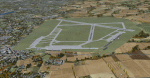
| Category: Flight Simulator X - Scenery | |
| Palm Springs International Airport (KPSP) PATCH |

|
File Description:
Patch for the Shez's FS2004 Palm Springs Regional Airport scenery to make it work in FSX
| Filename: | Palm_Springs_International_Airport_KPSP_PATCH.zip |
| License: | Freeware |
| Added: | 26th March 2009, 20:55:07 |
| Downloads: | 1,582 |
| Author: | P Nigel Grant, Shehryar Ansari |
| Size: | 400.96 KB |
| Category: Flight Simulator X - Scenery | |
| OBKH Sakhir AB and Sakhir F1 Circuit, BAHRAIN |
|
Images related to this file:
File Description:
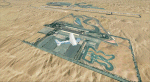
Photorealistic scenery for FSX (should work on P3D V 1-4).
Overlapping edges from photo into default scenery.
Enhanced airport close to real with custom buildings and some static objects.
Day and Night textures.
Some autogen at airport, circuit and surrounding areas.
FTX Global and Vector compatible.
| Filename: | OBKH_Sakhir_AB_and_Sakhir_F1_Circuit_BAHRAIN.zip |
| License: | Freeware |
| Added: | 18th June 2021, 22:12:25 |
| Downloads: | 472 |
| Author: | Ignacio Del Muro |
| Size: | 10.62 MB |
| Category: Flight Simulator X - Scenery | |
| Maya Flats Air Park - San Ignacio, Belize |
|
Images related to this file:
File Description:
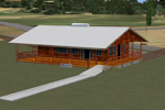
Airport files for Maya Flats Air Park in San Ignacio, Cayo District, Belize - ICAO code unassigned, IATA code CYD. For this package it has been assigned a provisional IATA code of MZMY for use in FSX. This airport has been created from scratch with custom AFCAD and scenery objects and includes nighttime textures.
| Filename: | Maya_Flats_Air_Park___San_Ignacio_Belize.zip |
| License: | Freeware, limited distribution |
| Added: | 21st December 2014, 14:00:16 |
| Downloads: | 373 |
| Author: | Chris Thompson |
| Size: | 927.88 KB |
| Category: Flight Simulator X - Scenery | |
| KDAL - Dallas Love Field West Concourse |
|
File Description:
Dallas Love Field - West Concourse for FSX. This scenery ia a high-quality, high-resolution representation of the Dallas Love field West Concourse, one of Southwest Airlines main hubs. It is a partial representation of the terminal complex only.
| Filename: | KDAL__Dallas_Love_Field_West_Concourse.zip |
| License: | Freeware, limited distribution |
| Added: | 17th February 2007, 15:37:36 |
| Downloads: | 2,488 |
| Author: | Ignacio Villegas / BluePrint Simulations |
| Size: | 2.07 MB |
| Category: Flight Simulator X - Scenery | |
| LFAW - Villerupt-Errouville |
|
Images related to this file:
File Description:
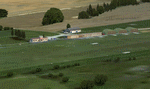
This scenery represents the field of Villerupt-Errouville LFAW where the flying club is based "Nord Lorraine" located in the north of the department 54 a few kilometers from Belgium and Luxembourg borders and the model aircraft club. The buildings have been modeled in GMAX, static devices are also present. Finally the autogen was placed on the same perimeter as the slab photo realistic.
********************************
Cette scene represente le terrain de Villerupt-Errouville LFAW qui est base l'aeroclub Nord Lorraine situe dans le nord du departement 54 a quelques kilometres de la Belgique et du Luxembourg ainsi qu'un club d'aeromodelisme et parachutisme.
L'ensemble des batiments ont ete modelises sous GMAX, des appareils statiques sont egalement presents.
Une dalle photo realiste a ete inseree mais je vous conseille de continuer le sol photo avec des logiciels comme fsEarthTile.
Enfin de l'autogen a ete place sur le meme perimetre que la dalle photo realiste.
| Filename: | LFAW__VilleruptErrouville.zip |
| License: | Freeware, limited distribution |
| Added: | 3rd January 2012, 11:24:06 |
| Downloads: | 1,861 |
| Author: | Alexandre Remy FAF010 |
| Size: | 17.72 MB |
| Category: Flight Simulator X - Scenery | |
| 6I2 - Lebanon-Springfield Airport - Kentucky, USA [FreeMeshX - USA-optimized] |
|
Images related to this file:
File Description:
Lebanon-Springfield Airport (FAA LID: 6I2), a public use airport in Washington County, Kentucky (KY), USA. It is located three nautical miles (6 km) south of Springfield in Washington County) and north of Lebanon (in Marion County). The airport is owned by Marion and Washington Counties. The scenery contains seasonal ground textures for winter, spring, summer, autumn and night; autogen and default scenery objects of FSX plus a modified AFCAD file. Tested with FSX: SE on Windows 10. Version 1.1 contains fixes for the terrain aswell as corrected scenery objects.
** Do not use this version with the default mesh; use 6I2_NO_FMX.zip instead **
By Peregrine Simulations
| Filename: | 6I2__LebanonSpringfield_Airport__Kentucky_USA_Free.zip |
| License: | Freeware, limited distribution |
| Added: | 21st February 2018, 23:36:13 |
| Downloads: | 414 |
| Author: | Peregrine Simulations |
| Size: | 104.1 MB |
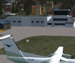
| Category: Flight Simulator X - Scenery | |
| SGD Airport - FIMR |
|
File Description:
This is my second contribution to making default scenery look closer to 'real life' with the means I have using default library. Sir Gaetan Duval Airport connecting Rodrigues with the the world via Mauritius. At this time only Air Mauritius serves the island but you can always fly there with aircraft no larger than ATR70 although you can try a B732. Download see for yourself and enjoy.
| Filename: | SGD_Airport__FIMR.zip |
| License: | Freeware |
| Added: | 24th February 2009, 08:33:11 |
| Downloads: | 2,089 |
| Author: | Deenesh Suddoo |
| Size: | 154.89 KB |
| Category: Flight Simulator X - Scenery | |
| Ultimate Macedonia v1.2 |
|
Images related to this file:
File Description: Vector scenery for Macedonia based on data from 'European Environment Agency'
(land cover) and 'OpenStreetMap'(road, rail and water). Included data: road and
rail networks, water bodies, rivers, streams, continuous urban fabric,
discontinuous urban fabric, industrial or commercial units, mineral extraction
sites, forest, pastures, vineyards etc. Data covers the whole country.

This upload supersedes file: fsx_ultimate_macedonia.zip
| Filename: | Ultimate_Macedonia_v12.zip |
| License: | Freeware, limited distribution |
| Added: | 1st May 2014, 17:34:38 |
| Downloads: | 1,063 |
| Author: | Sami Toronen |
| Size: | 14.2 MB |
| Category: Flight Simulator X - Scenery | |
| ENOV-Orsta Volda Hovden v2 |
|
Images related to this file:
File Description:
Freeware scenery made by Knudsenair simulations. Scenery is V2 of ENOV in Norway regional pack.
Ørsta–Volda Airport, Hovden (Norwegian: Ørsta–Volda lufthamn, Hovden; IATA: HOV, ICAO: ENOV) is a regional airport situated at Hovden (Hovdebygda), in Ørsta, Norway, midway between the towns of Ørsta and Volda. The airport features a 1,070-meter (3,510 ft) asphalt runway aligned 06/24. Services are provided by Widerøe using their de Havilland Canada Dash 8 as a public service obligation.
| Filename: | ENOVOrsta_Volda_Hovden_v2.zip |
| License: | Freeware |
| Added: | 29th April 2020, 19:17:25 |
| Downloads: | 317 |
| Author: | Knudsenair simulations |
| Size: | 389.98 KB |
| Category: Flight Simulator X - Scenery | |
| ETBG Reichenhall/Berchtesgaden airfield |
|
Images related to this file:
File Description:
Reichenhall/Berchtesgaden airfield was constructed as Government airport in 1934 to serve Hitlers Berghof at Obersalzberg. Nowadays, it is mainly a residential area in Ainring-Mitterfelden.
| Filename: | ETBG_ReichenhallBerchtesgaden_airfield.zip |
| License: | Freeware |
| Added: | 13th January 2025, 15:58:00 |
| Downloads: | 46 |
| Author: | Mario Kassmann |
| Size: | 687.56 KB |
© 2001-2026 AVSIM Online
All Rights Reserved
Privacy Policy |