
Where Flight Simulation Enthusiasts Gather from Around the World!
AVSIM Library - Search Results

| Category: Flight Simulator X - Scenery | |
| Icabaru (SVIC) & Wonken (SVUQ) - Venezuela |

|
Images related to this file:
File Description:
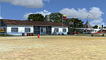
Two small airports located south of Venezuela, especially for VFR flights:
- Icabaru is one of the oldest mining towns in the region located near the border with Brazil.
- Wonken is located in the Canaima National Park, only 15 minutes by plane from Santa Elena de Uairen.
Photo-terrain area improved with Autogen files. Not compatible with versions prior to FSX. Also includes a friendly Auto-Install.
| Filename: | svic_svuq.zip |
| License: | Freeware |
| Added: | 18th January 2014, 16:29:41 |
| Downloads: | 928 |
| Author: | David Maldonado |
| Size: | 83.38 MB |
| Category: Flight Simulator X - Scenery | |
| (SVPA) Puerto Ayacucho Airport - Venezuela |
|
Images related to this file:
File Description:
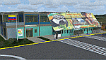
Low-capacity airport mostly used by tourist agencies with
locations in Amazonas state, although it's used as a terminal
for the armed forces and security agencies of the state due
to its proximity to the Colombian border
With photo-terrain scenery from satellite imagery
of Yahoo Satellite.
Not compatible with versions prior to FSX.
This scenery includes terminal building with realistic
textures from images obtained from Internet.
Also includes a friendly Auto-Install.
| Filename: | svpa_fsx.zip |
| License: | Freeware |
| Added: | 6th August 2012, 18:16:00 |
| Downloads: | 1,756 |
| Author: | David Maldonado |
| Size: | 54.74 MB |
| Category: Flight Simulator X - Scenery | |
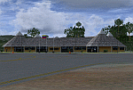
| SVST - San Tome - Anzoategui, Venezuela |
|
Images related to this file:
File Description:
The San Tome Airport is located in San Tome, Anzoategui, Venezuela .
This airport serves the city of El Tigre, and San Jose which is 15 km from San Tome.
It reopened in 2005 with infrastructure improvements and the beaconing for night flights ,
has a runway 1920 m .
Photo-terrain area improved with Autogen files.
Only compatible with FSX, P3Dv1.x or P3Dv2.x.
Also includes a friendly Auto-Installer.
| Filename: | svst_san_tome.zip |
| License: | Freeware |
| Added: | 15th October 2015, 23:24:00 |
| Downloads: | 1,110 |
| Author: | David Maldonado |
| Size: | 87.15 MB |
| Category: Flight Simulator X - Scenery | |
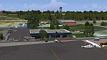
| SVCB - Ciudad Bolivar Airport - Venezuela |
|
Images related to this file:
File Description:

The National Airport "Tomas de Heres", located in the city of Ciudad BoliÃ�ÂÂvar, to the south of Venezuela, near the Orinoco River. is one of the airports with more domestic and tourist traffic, due to his geographical position. Photo-terrain area improved with Autogen files.
Only compatible with versions of FSX, P3Dv1.x or P3Dv2.x. Also includes a friendly Auto-Install.
| Filename: | svcb_setup.zip |
| License: | Freeware |
| Added: | 27th July 2014, 18:03:14 |
| Downloads: | 2,107 |
| Author: | David Maldonado |
| Size: | 84.71 MB |
| Category: Flight Simulator X - Scenery | |
| SVPR |
|
File Description:
Manuel Carlos Piar Guayana Airport (IATA: PZO, ICAO: SVPR), is an airport serving the cities of Ciudad Guayana and Puerto Ordaz, Venezuela. Airlines and destinations: Aeropostal Alas de Venezuela (Caracas, MaturÃ�ÂÂn), Aserca Airlines (Barcelona, Valencia and Caracas), Avior Airlines (Caracas), Conviasa (Porlamar), Rutaca (Caracas, Porlamar, Ciudad Bolivar), Canaima Tours (Canaima), Serami (Porlamar, Maturin, Barcelona, Canaima, Santa Elena de Uairen), Rainbow air (Porlamar)
This file has the right coordinates, with the apron and characteristics of the airport. The runways and runways were resized the gates placed on correct location.
| Filename: | svpr.zip |
| License: | Freeware |
| Added: | 21st April 2011, 03:53:06 |
| Downloads: | 828 |
| Author: | Anwar Gonzalez |
| Size: | 9 KB |
| Category: Flight Simulator X - Scenery | |
| FIX for "Lago de Valencia" |
|
File Description:
This is a small fix for elevation problem on Valencia's Lake (Lago de Valencia) in Venezuela
It's a early version so I will add small islets in the future.
Please, see the picture to understand the problem.
| Filename: | lagovalencia1.zip |
| License: | Freeware, limited distribution |
| Added: | 3rd September 2008, 23:38:34 |
| Downloads: | 931 |
| Author: | Alexander Garzon |
| Size: | 72 KB |
| Category: Flight Simulator X - Scenery | |
| Angel Falls, Canaima National Park, Venezuela |
|
Images related to this file:
File Description:
Angel Falls, Canaima National Park, Venezuela. Discovered in 1933 by an American pilot, Jimmie Angel, Angel Falls is located on Auyan Tepui near Canaima (SVCN). It's the world's highest waterfall with a height of 979 meters. See the readme text for more information about installation and required meshes.
| Filename: | angelfalls.zip |
| License: | Freeware, limited distribution |
| Added: | 13th February 2010, 14:27:54 |
| Downloads: | 1,837 |
| Author: | Jean St-Cyr |
| Size: | 18 KB |
| Category: Flight Simulator X - Scenery | |
| Santa Elena de Uairen, Venezuela (SVSE) |
|
Images related to this file:
File Description:
Located to south of Venezuela, to few kilometers from the border with Brazil.
The airport design, reflects the Pemon indigenous culture.
With photo-terrain scenery from satellite imagery of Google Earth.
Not compatible with versions prior to FSX.
This scenery requires SP1, SP2, or the Acceleration
expansion pack in order to be displayed correctly.
Also includes a friendly Auto-Install.
| Filename: | svse_fsx.zip |
| License: | Freeware |
| Added: | 3rd August 2013, 17:34:22 |
| Downloads: | 1,370 |
| Author: | David Maldonado |
| Size: | 76.58 MB |
| Category: Flight Simulator X - Scenery | |
| SVCS |
|
File Description:
Oscar Machado Zuloaga International Airport is an small airport locate in the town of Charallave in the Miranda state, Venezuela.
This file has the right coordinates, with the apron and characteristics of the airport. The runways and runways were resized the gates placed on correct location.
| Filename: | svcs_287744.zip |
| License: | Freeware |
| Added: | 21st April 2011, 23:38:18 |
| Downloads: | 694 |
| Author: | Anwar Gonzalez |
| Size: | 10 KB |
| Category: Flight Simulator X - Scenery | |
| SVCR |
|
File Description:
Jose Leonardo Chirino Airport (IATA: CZE, ICAO: SVCR), is an small airport in the coast town of Santa Ana de Coro, Venezuela
This file has the right coordinates, with the apron and characteristics of the airport, working jetways. The runways and runways were resized the gates placed on correct location.
| Filename: | svcr.zip |
| License: | Freeware |
| Added: | 15th April 2011, 01:06:21 |
| Downloads: | 608 |
| Author: | Anwar Gonzalez |
| Size: | 5 KB |
© 2001-2025 AVSIM Online
All Rights Reserved