
Where Flight Simulation Enthusiasts Gather from Around the World!
AVSIM Library - Search Results

| Category: Flight Simulator X - Scenery | |
| BOP Islands Redux- Photo Scenery |

|
File Description:
These file supersedes all my previous BOP Islands releases and was re-uploaded due to the AVSIM hack- It contains all of the 4 BOP Island releases (including the High Resolution Whale Island aerial and mesh).
Sceneries contain autogenned aerial images, placed objects, effects and runways where appropriate in order to increase the realism of these Islands off the coast of New Zealand.
| Filename: | BOP_Islands_Redux_Photo_Scenery.zip |
| License: | Freeware, limited distribution |
| Added: | 17th April 2010, 19:38:50 |
| Downloads: | 1,656 |
| Author: | Tim Barnes |
| Size: | 55.46 MB |
| Category: Flight Simulator X - Scenery | |
| NZWV - Waihi Beach Airfield, New Zealand |
|
Images related to this file:
File Description:
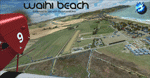
Waihi Beach (ICAO: NZWV) is a small airstrip north of Tauranga and near the small beach settlement of the same name, in the Bay of Plenty of New Zealand. It is a grass strip with offset thresholds giving usable landing lengths of 640m and 517m for RWY 13 and 31 respectively, a width of 55m and a group rating of 5. No night lighting or fuel is available. A very basic airstrip, there is only one recently built hanger and the airstrip is slowly being encroached on by
new housing developments. The airstrip itself is usually very sodden due to its low elevation but is a nice stop over for sightseeing from Tauranga and up the Coromandel peninsula.
The FSX model includes custom textures and models placed on a high resolution aerial image and a 15m mesh. It makes extensive use of items from the free VLC object libraries which are required to be installed (Available from www.vectorlandclass.co.nz Downloads menu). This scenery and
the VLC libraries have been funded by sales of VectorLandClass and although you do not need VLC to use it, your purchase helps further development.
| Filename: | vlc_waihibeach_install.zip |
| License: | Freeware, limited distribution |
| Added: | 1st November 2012, 10:01:38 |
| Downloads: | 997 |
| Author: | Tim Barnes / VectorLandClass |
| Size: | 11.13 MB |
| Category: Flight Simulator X - Scenery | |
| NZGA- Galatea Aerodrome (VectorLandClass, New Zealand) |
|
Images related to this file:
File Description:
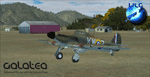
Welcome to Galatea (ICAO: NZGA), a gateway to exploring the Urewera ranges and the east coast of New Zealand. Galatea is a small and basic airstrip with only one old hanger, a public toilet and a small clubhouse on a wide plain surrounded by native bush and pine plantation near Murupara in the Bay of Plenty of New Zealand. It is a grass strip of 1025m length and 60m width and aligned 01/19 with a group rating of 8. No night lighting or fuel is available.
The FSX model includes custom textures and models placed on an aerial image. It makes extensive use of items from the free VLC object libraries which are required to be installed (download from www.vectorlandclass.co.nz downloads menu). This scenery and the VLC libraries have been funded
by sales of VectorLandClass and although you do not need VLC to use it, your purchase helps further development.
To the south west of Murupara township and sawmill is the LakeLand Helicopters base which just fits onto the photo-real coverage. Library objects have been placed here although they may not be accurate as the site was not visited when taking reference photos. This airfield makes a great stop over when flying between Rotorua, Mount Tarawera, Whakatane or Gisborne.
We hope you enjoy exploring the area!
| Filename: | vlc_galatea_install.zip |
| License: | Freeware, limited distribution |
| Added: | 15th November 2012, 23:35:42 |
| Downloads: | 1,114 |
| Author: | Tim Barnes / VectorLandClass |
| Size: | 45.71 MB |
| Category: Flight Simulator X - Scenery | |
| Kiwi360 (KiwiFruit Country)- Custom buildings, helipad, Hi Res photoreal, Aerius R22 Repaint. Te Puke, New Zealand |
|
File Description:
Kiwi360 (formally know as Kiwifruit Country) is a theme park based around the Kiwifruit (AK.A Chinese Gooseberry or Zespri- The trade name) which is a major export of New Zealand grown predominately in the Bay of Plenty Region. The park is situated about midway between Tauranga and Whakatane, about 5km east of the township of Te Puke.
The Bay of Plentys sunny climate ensures good growing conditions for the delicious fruit and has also spawned a mini tourist industry of tours of the orchards and sorting/packing/coolstores. These include tourist flights by Aerius (http://www.aerius.co.nz ) using a Robinson R44 helicopter.
This scenery was made after a visit when carrying out a GPS survey: I took a few photos and whacked it up. It isn't perfect but will be useful for flights in small helos (I.e. Robinson R22, R44 or Hughes 300/269).
It includes the famous giant Kiwifruit slice, the helipad next to it; the main Kiwi 360 building; a large coolstore/packhouse and the backpackers next to the park. It also includes a lot of library objects (especially trees- If these are adversely affecting performance, you can disable this bgl)
This is placed on a high resolution aerial photo provided by Environment Bay of Plenty.
The scenery also has reflection maps and night maps for those who like getting up at the crack of dawn or simulating frost protection work (although I don't believe the pad is certified for night operations in real life).
The download also includes a repaint of the default Robinson R22 in the colours of ZK-HJZ (in actual fact an R44) kindly provided by James Eden from the ARNZ Forums (see the readme for the .cfg entry to add this repaint)
This helipad isn't in controlled airspace but Tauranga Tower is nearby and will need to be called before entering their airspace (above 2500ft LL for the CTA or within about 10nm of Tauranga for the CTZ) Radio procedures are carried out on Christchurch Information 125.5 for flight following/planning.
| Filename: | kiwi360.zip |
| License: | Freeware, limited distribution |
| Added: | 29th June 2008, 06:05:29 |
| Downloads: | 2,452 |
| Author: | Tim Barnes, James Eden |
| Size: | 11.75 MB |
| Category: Flight Simulator X - Scenery | |
| Springhill Aerodrome (New Zealand) |
|
Images related to this file:
File Description:

SpringHill (ICAO: NZSL) is a small airstrip between Warkworth and Wellsford, north of Auckland in New Zealand. It is privately owned tarseal strip with offset thresholds giving usable landing lengths of 680m and 700m for RWY 16 and 34 respectively, a width of 10m and a group rating of 5. The runway is aligned 16/34. The tar seal strip is supplemented by a grass strip of the same length but 30m wide. No night lighting or fuel is available.
I decided to model it after doing a roadtrip north of Auckland and taking lots of reference photos of the smaller airfields suitable for the size of aircraft I fly in real life. I am also planning to model Parakai aerodrome in the near future and Kaipara flats has already been modelled.
It contains fully custom Gmax buildings and phototextures.
| Filename: | springhill.zip |
| License: | Freeware, limited distribution |
| Added: | 28th December 2009, 11:49:01 |
| Downloads: | 1,136 |
| Author: | Tim Barnes (Visualise IT) |
| Size: | 1.13 MB |
| Category: Flight Simulator X - Scenery | |
| Lost River ASU Observatories |
|
Images related to this file:
File Description:
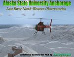
This is a fictitous scenery of the Alaska State University operated North-Western observatories.
It is located near LSR_Lost River and AK45_Lost River_2 on the Western coast of Alaska.
LSR, AK45 and KPC_Port Clarence have been upgraded with hangers and various objects.
LSR, AK45 and the (2) mountain top observatories have been upgraded with helipads along with various ground vehicles including snocats, aircraft, misc buildings and hangers. The main observatory complex has a main rooftop pad and a heli-tower. These helipads were designed for heli practice. some are on the ground and others are a bit more challenging.
There is a map included which shows the locations of the observatory complexes in relation to the airports. There is also a small research facility located to the east which is indicated on the map. This fictional scenery was design with default FSX 3D objects and (1) addon library, fa_ez-arctic_set by Finney Air, Robert Finnegan.
| Filename: | lost_river_asu_observatories.zip |
| License: | Freeware |
| Added: | 11th November 2009, 19:11:39 |
| Downloads: | 554 |
| Author: | Tim Durham |
| Size: | 3.44 MB |
| Category: Flight Simulator X - Scenery | |
| Palmer USCG Helobase.zip |
|
Images related to this file:
File Description:
A fictitous USCG helo base located east of Palmer Municipal airport in Alaska. The scenery has a water runway, float plane dock, a repair area with a usable ramp up to a dry dock and repair hanger. Added two new bridges, two cargo docks, 9 helipads with one as a start point and many other additions to enhance your FS world. Test your skills as you fly in and taxi up to the ramp, then up to the dry dock without over shooting it and ending in the repair hanger. Lots of candies on the base for your flying pleasure. By savageagle......AW702_savag
| Filename: | palmer_uscg_helobase.zip |
| License: | Freeware |
| Added: | 26th May 2010, 03:35:08 |
| Downloads: | 598 |
| Author: | Tim Durham |
| Size: | 5.04 MB |
| Category: Flight Simulator X - Scenery | |
| Mystic Rock Resort, Alaska (fictional) |
|
Images related to this file:
File Description:
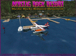
This Mystic Rock Resort (Mystic Rocks Nat'l Monument) is fictitious and located 35 miles west of Ketchikan, Alaska. It's main attraction are the huge rocks left here some 2.6 million years ago, when glaciers covered the northern hemisphere - as the glaciers moved south they brought these rocks more than 600 miles leaving them at their current locations.
The resort has a water runway and helipad, two start locations, an NDB (ADF) frequency of 302.0 and many, many attractions. Your visit may lead to running tours by helo or small float plane to these geological wonders. Designed with a clean FSX installation and to enhance your FS world. Read the text files and Please enjoy. savageagle.
| Filename: | mystic_rock_resort.zip |
| License: | Freeware |
| Added: | 31st May 2010, 10:51:09 |
| Downloads: | 509 |
| Author: | Tim Durham |
| Size: | 1.35 MB |
| Category: Flight Simulator X - Scenery | |
| Sunset Point |
|
File Description:
A fictitious Sunset Point located 58 NM south-east of Juneau Int'l airport with VOR/DME @ 115.100, a water landing and helipad, Sunset Point Lodge, cabin rentals and great fishing. Various FS candies located around the area and a great place to stop over or stay awhile. Created with Instant Scenery and default FSX 3D objects. Designed with bush pilots in mind and enhancing your bush flying in the great state of Alaska. Enjoy! By Savageagle
| Filename: | sunset_point_fsx.zip |
| License: | Freeware |
| Added: | 24th January 2010, 11:16:42 |
| Downloads: | 663 |
| Author: | Tim Durham |
| Size: | 715 KB |
| Category: Flight Simulator X - Scenery | |
| Summit Lake_FSX.zip |
|
File Description:
This is a small upgrade to Summit Lake 52Z. Includes float plane and fueling docks, private home, cabins around the lake, a smaller home/maintenance shop and sheds and 2 jeeps. Default FSX objects used with Instant Scenery. Summit Lake is ESE of PANC. enjoy your stops at Summit Lake. Done by savageagle.......Enjoy!
| Filename: | summit_lake_fsx.zip |
| License: | Freeware |
| Added: | 28th January 2010, 14:58:33 |
| Downloads: | 484 |
| Author: | Tim durham |
| Size: | 266 KB |
© 2001-2025 AVSIM Online
All Rights Reserved