
Where Flight Simulation Enthusiasts Gather from Around the World!
AVSIM Library - Search Results

| Category: Flight Simulator X - Scenery | |
| Horn Of Africa Mesh, part 1/3 |

|
Images related to this file:
File Description:

Part 1 of 3: Mesh (lod 1 to 9) of the "Horn Of Africa": Ethiopia, Erythrea, Djibouti and Somalia. (Re-upload)
| Filename: | Horn_Of_Africa_Mesh_part_13.zip |
| License: | Freeware, limited distribution |
| Added: | 10th June 2010, 08:57:38 |
| Downloads: | 2,252 |
| Author: | Marcel "Teutonique" Wislet |
| Size: | 82.73 MB |
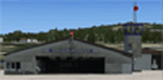
| Category: Flight Simulator X - Scenery | |
| Harare International Airport, Zimbabwe,Africa |
|
Images related to this file:
File Description:
Harare International Airport in Zimbabwe Africa. A complete custom designed airport with custom designed terminals,hangars and admin buildings.I t also has a custom AFCAD and a photoreal base that changes with the seasons. Works best with FSX acceleration or SP2. Acceleration users will have more eye candy !
| Filename: | Harare_International_Airport_ZimbabweAfrica.zip |
| License: | Freeware |
| Added: | 12th October 2010, 19:31:57 |
| Downloads: | 1,750 |
| Author: | Jacques Botha and Frits Beyer |
| Size: | 2.16 MB |
| Category: Flight Simulator X - Scenery | |
| Sudan/South Sudan |
|
File Description:
I upgraded default airports in Sudan and South Sudan by adding parking, fuel trucks, navaids, taxiway markings, and other items so that they would be "AI-friendly" as well as making my flights in the region more interesting. Place the contents of the zip file in "Addon Scenery/Scenery" and click "OK" in the Scenery Library.
Please address any questions to me: [email protected]
| Filename: | SudanSouth_Sudan.zip |
| License: | Freeware |
| Added: | 19th May 2023, 20:01:04 |
| Downloads: | 184 |
| Author: | Barry Woodward |
| Size: | 46.01 KB |
| Category: Flight Simulator X - Scenery | |
| HeliTraffic 2009 - New Zealand South Island Landing Spots |
|
Images related to this file:
File Description:

Flight1 HeliTraffic 2009 New Zealand South Island Landing Spots
New Zealand South Island Landing Spots for HeliTraffic 2009 by Flight 1. Covers FTX NZSI and fs-creations compatible products for New Zealand South Island. Requires HeliTraffic 2009 by Flight 1.
| Filename: | HeliTraffic_2009__New_Zealand_South_Island_Landing.zip |
| License: | Freeware |
| Added: | 12th February 2012, 14:47:48 |
| Downloads: | 169 |
| Author: | Matt Levi, Flight 1 |
| Size: | 5.22 KB |
| Category: Flight Simulator X - Scenery | |
| KCAE - Columbia South Carolina Metropolitan Airport - South Carolina, USA |
|
Images related to this file:
File Description:
Columbia South Carolina Metropolitan Airport for FSX. Several improvements have been made to the default airport, including replacing the default terminal with new buildings modelled in FSDS, correctly numbering and coding gates using Airport Design Editor 1.67.5684, creating a new vehicle network, adding ample GA parking, changing the tower view to the roof of the control tower, adding a new static UPS truck modelled in FSDS in three different color schemes, placing static aircraft created using Static Aircraft Model Maker, and including the option of having all runways open to AI traffic.
Also included are Jim Dhaenen's excellent ramp lights and a set of GA flight plans made using AI flight Planner using all FSX default aircraft to liven up the GA area. Please read the README FIRST.txt and installation.txt files to insure proper installation of all files.
| Filename: | KCAE__Columbia_South_Carolina_Metropolitan_Airport.zip |
| License: | Freeware |
| Added: | 20th December 2015, 16:35:16 |
| Downloads: | 1,357 |
| Author: | Patrick Finch |
| Size: | 3.72 MB |
| Category: Flight Simulator X - Scenery | |
| Bimini, The Bahamas (MYBS) |
|
Images related to this file:
File Description:
Both North and South Bimini islands landclass, shorelines and water, as well as the South Bimini Airport, have been redone per Google Earth images. This is NOT photo scenery.
| Filename: | Bimini_The_Bahamas_MYBS.zip |
| License: | Freeware |
| Added: | 7th March 2010, 12:08:16 |
| Downloads: | 2,678 |
| Author: | Art Poole |
| Size: | 314.96 KB |
| Category: Flight Simulator X - Scenery | |
| EDQL Lichtenfels South Germany |
|
Images related to this file:
File Description:
Re-upload. Photo Scenery of Lichtenfels/South Germany
for FSX SP2 DX9
by Uwe Schweitzer
| Filename: | EDQL_Lichtenfels_South_Germany.zip |
| License: | Freeware |
| Added: | 26th May 2010, 03:21:42 |
| Downloads: | 2,258 |
| Author: | Uwe Schweitzer |
| Size: | 2.09 MB |
| Category: Flight Simulator X - Scenery | |
| Mesh-South America MeSA_G04 |
|
File Description:
FSX Mesh South America Project:
This terrain mesh file is a part of a whole project covering all the Continent
of South America and some islands, divided in tiles identified in a map by its
column (letters) and rows (numbers).
Those files were multi-LOD compiled from 90m SRTM2 source data, reprocessed
with 3DEM to remove voids and spikes, providing a 76.4m (LOD9) horizontal
resolution topography intended for use only in FSX updated with SP1.
Although not well documented, to improve performance, the updated FSX loads DEM
files in threads and only the closer terrain (about 5-10 NM from the point of view)
is rendered in high detail, while at far distances FSX shows up its default low
resolution mesh, when there is not a third part terrain mesh compiled in all
others intermediate level of details (multi-LOD).
THIS FILE:
FSX_MeSA_G04 (Column G x Row 04)
covers the area inside the boundaries:
N = 0º 0' S; S = 5º 37.5' S;
W = 45º 0' W; E = 37º 30' W;
AUTHORS:
Hely Heck Junior - Magrao ( [email protected] )
and Jose Lobo ( [email protected] )
TerraBrasilis: www.terra-brasilis.org
| Filename: | MeshSouth_America_MeSA_G04.zip |
| License: | Freeware |
| Added: | 15th June 2007, 00:10:58 |
| Downloads: | 867 |
| Author: | Hely Heck Jr. and José Lôbo |
| Size: | 35.9 MB |
| Category: Flight Simulator X - Scenery | |
| South America Mesh, MeshX_B10 |
|
File Description:
Mesh terrain scenery for the whole continental South America, based on SRTM 90m
dem geotiff files,
resampled to 76 meter of horizontal resolution (LOD 9). The new files have
improved the vertical resolution from 16m to 10m, resulting in more details
and accuracy over previous versions. There are 50 files, compatible with FS 9
and FS X, identified in a map by column letter and line number, covering the
contiguous countries and states. Boundaries: N = 39º 22.5' S; S = 45º 0' S;
E = 63º 45' W; W = 71º 15' W.
| Filename: | South_America_Mesh_MeshX_B10.zip |
| License: | Freeware |
| Added: | 30th October 2006, 01:47:45 |
| Downloads: | 2,207 |
| Author: | Oséas Dourado, José Lôbo |
| Size: | 32.13 MB |
| Category: Flight Simulator X - Scenery | |
| Mesh-South America MeSA_E10 |
|
File Description:
FSX Mesh South America Project:
This terrain mesh file is a part of a whole project covering all the Continent
of South America and some islands, divided in tiles identified in a map by its
column (letters) and rows (numbers).
Those files were multi-LOD compiled from 90m SRTM2 source data, reprocessed
with 3DEM to remove voids and spikes, providing a 76.4m (LOD9) horizontal
resolution topography intended for use only in FSX updated with SP1.
Although not well documented, to improve performance, the updated FSX loads DEM
files in threads and only the closer terrain (about 5-10 NM from the point of view)
is rendered in high detail, while at far distances FSX shows up its default low
resolution mesh, when there is not a third part terrain mesh compiled in all
others intermediate level of details (multi-LOD).
THIS FILE:
FSX_MeSA_E10 (Column E x Row 10)
covers the area inside the boundaries:
N = 33º 45' S; S = 39º 22,5' S;
W = 60º 0' W; E = 52º 30' W;
AUTHORS:
Hely Heck Junior - Magrao ( [email protected] )
and Jose Lobo ( [email protected] )
TerraBrasilis: www.terra-brasilis.org
| Filename: | MeshSouth_America_MeSA_E10.zip |
| License: | Freeware |
| Added: | 14th June 2007, 13:59:05 |
| Downloads: | 943 |
| Author: | Hely Heck Jr. and José Lôbo |
| Size: | 21.54 MB |
© 2001-2026 AVSIM Online
All Rights Reserved
Privacy Policy |