
Where Flight Simulation Enthusiasts Gather from Around the World!
AVSIM Library - Search Results

| Category: Flight Simulator X - Scenery | |
| Goma Intl (FZNA) DRC and Gisenyi (HRYG) Rwanda |

|
Images related to this file:
File Description:
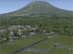
This project includes the neighboring Goma Intl (FZNA) and Gisenyi (HRYG) airports. After Goma's only runway was severely damaged by the eruption of Mount Nyiragongo in 2002, the runway, originally 3000m long, was reduced to 1800m of serviceable pavement after lava flowed onto the northern part runway and through the city center. In 2013, German NGO Welthungerhilfe ("World Hunger Aid") signed a contract to rehabilitate 500m of runway damaged by the lava flow. Goma resumed scheduled international flights in 2015, and this project reflects the airport as of March 2016, with runway 18/36 renumbered to 17/35. SRTMGL1 (30m) mesh brings the volcanoes in the area into much greater detail. This scenery is complimented by the Kigali Intl (HRYR) scenery (FSX_HRYR_Kigali_2016.zip).
Updates were created or rebuilt in a manner which carefully aligns airport data with current satellite imagery. Scenery was created using Airport Design Editor X v1.70.6042, SBuilderX 3.13, and the FSX Object Placement Tool. Scenery objects were added and modified from stock FSX scenery to resemble as closely as possible the actual airports. The FSX apron lights included are from the set created by Jim Dhaenens.
| Filename: | Goma_Intl_FZNA_DRC_and_Gisenyi_HRYG_Rwanda.zip |
| License: | Freeware |
| Added: | 4th August 2016, 21:11:20 |
| Downloads: | 2,276 |
| Author: | Carlyle Sharpe |
| Size: | 5.25 MB |
| Category: Flight Simulator X - Scenery | |
| Murray river and SE Victoria v2 for ORBX v2. YRIO Robinvale YBRN Balranald YDLQ Deniliquin YLEG Leongatha YYRM Yarram |
|
Images related to this file:
File Description:
'Murray and SE Victoria v2' is made to match ORBX Australia v2 scenery. Use 'Murray + SE Victoria airports' for ORBX v1 or no ORBX. There are 5 airports. 3 airports near the Murray river in Victoria and NSW - YRIO Robinvale, YBRN Balranald, YDLQ Deniliquin. 2 airports in SE Victoria - YLEG Leongatha, YYRM Yarram. ORBX has done these as they have done every airport included with FSX in Australia to a reasonable standard. If I had not already done them for ORBX V1 I would not have bothered. However these are better than ORBX because the surroundings have been modified to match real life. Towns have been added or shifted. Forests cut down or added. Race courses, sewage treatment ponds and other stuff added. Local obstacles (towers etc) added. There are Included are 2 AI traffic files that cover the airports. These files are for Flight Simulator X. Made using Airport Design Editor using some objects borrowed from Robert Budd's excellent Baccus Marsh and 'Static aircrafts' by Jean-Pierre Fillion. REQUIRED The scenery is designed to interface with ORBX FTX_AU V2 scenery for Australia (payware).
| Filename: | Murray_river_and_SE_Victoria_v2_for_ORBX_v2_YRIO_R.zip |
| License: | Freeware |
| Added: | 15th December 2019, 19:06:10 |
| Downloads: | 315 |
| Author: | Colin Jeffery |
| Size: | 10.06 MB |
| Category: Flight Simulator X - Scenery | |
| Oahu Scenery Version 1 |
|
File Description:
This scenery sits on top of "MegaSceneryX - Hawaii - Honolulu and Oahu Island", SO IT REQUIRES THE MEGASCENERY X - Hawaii - Honolulu & Oahu Island" photo scenery from http://www.megascenery.com/
This is primarily an Autogen scenery with some custom developed objects for the coast of Oahu.
I used autogens from default FSX for the most part as well as the FSX Acceleration. IF you did not install acceleration, it should not be an issue. you would just not see some of the autogens from the acceleration package. I have also included some custom built GMAX Objects with this package. There is also an AFCAD file for a new fictitious Heliport that is included ("PMMH)".
This scenery package also includes a Mission called "Oahu Sacred Falls Landing". It is a short mission without any surprises or twists, yet I am confident many of you would find it interesting and very very challenging. But do not be discouraged at the difficulty of completing the mission. You may want to turn off crash detection to make it easier if you'd like. The fun is in the journey..right?
Lastly, I have included a fix for my MM_PHNGv1 scenery as part of this package.
| Filename: | Oahu_Scenery_Version_1.zip |
| License: | Freeware, limited distribution |
| Added: | 29th February 2008, 02:31:04 |
| Downloads: | 4,125 |
| Author: | Manny Mahadevan |
| Size: | 9.9 MB |
| Category: Flight Simulator X - Scenery | |
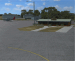
| West Coast Victoria v2 for ORBX v2 YWBL Warrnambool YPOD Portland YPFA Port Fairy |
|
Images related to this file:
File Description:

'West Coast Victoria v2' is made to match ORBX Australia v2 scenery. Use 'West Coast Victoria' for ORBX v1 or no ORBX. There are 3 airports YWBL Warrnambool YPOD Portland YPFA Port Fairy. ORBX has done 2 of these (YWBL, YPOD) as they have done every airport included with FSX in Australia to a reasonable standard. If I had not already done them for ORBX V1 I would not have bothered. However these are better than ORBX because the surroundings have been modified to match real life. Towns have been added or shifted. Forests cut down or added. There are also custom accurate versions of the actual terminal buildings. Included are AI traffic files that cover all 3 airports + YHML Hamilton nearby (little or no traffic from ORBX). In short a lot more time spent. ORBX had to do every airport has in Australia! Recommend installing the excellent YHML Hamilton (by Anthony Lynch). These files are for Flight Simulator X. Made using Airport Design Editor using some objects borrowed from Robert Budd's excellent Baccus Marsh and 'Static aircrafts' by Jean-Pierre Fillion. REQUIRED The scenery is designed to interface with ORBX FTX_AU V2 scenery for Australia (payware).
| Filename: | West_Coast_Victoria_v2_for_ORBX_v2____YWBL_Warrnam.zip |
| License: | Freeware |
| Added: | 8th October 2019, 20:00:14 |
| Downloads: | 321 |
| Author: | Colin Jeffery |
| Size: | 8.56 MB |
| Category: Flight Simulator X - Scenery | |
| East Coast Victoria v2 for ORBX v2 YLKE Lakes Entrance YGRL Great Lakes Airport YORB Orbost YMCO Mallacoota |
|
Images related to this file:
File Description:
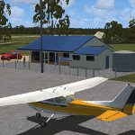
'East Coast Victoria v2' is made to match ORBX Australia v2 scenery. For ORBX v1 or no ORBX use 'East Coast Victoria'. There are 4 airports. YLKE Lakes Entrance YGRL Great Lakes Airport YORB Orbost YMCO Mallacoota. ORBX has done 2 of these (YORB, YMCO) as they have done every airport included with FSX in Australia to a reasonable standard. If I had not already done them for ORBX V1 I would not have bothered. However these are better than ORBX because the surroundings have been modified to match real life. Towns have been added or shifted. Forests cut down or added. There are also custom accurate versions of the terminal buildings. Included is an AI traffic files that covers the airports (little or no traffic from ORBX). In short a lot more time spent by me as I did not have to do every airport in Australia! These files are for Flight Simulator X. Made using Airport Design Editor using some objects borrowed from Robert Budd's excellent Baccus Marsh. REQUIRED The scenery is designed to interface with ORBX FTX_AU V2 scenery for Australia (payware).
| Filename: | East_Coast_Victoria_v2____for_ORBX_v2____YLKE_Lake.zip |
| License: | Freeware |
| Added: | 16th September 2019, 16:27:48 |
| Downloads: | 388 |
| Author: | Colin Jeffery |
| Size: | 6.32 MB |
| Category: Flight Simulator X - Scenery | |
| Extreme Westgreenland |
|
File Description:
Extreme Westgreenland
Terrain Mesh for Greenland for Microsoft Flight Simulator X
Everybody who flies in Greenland knows, how incorrect the default scenery is.
This is a new terrain mesh scenery which covers Westgreenland - from Lat N 65 to N 68.
As SRTM data do not cover above N 60 - no Greenland mesh scenery has been produced.
This is one of the most detailed Greenland terrain mesh released up to release date of this scenery.
This great package covers more than 50.000 sq. km. area. This includes:
* LOD11 Mesh (terrain/elevation)
* Redesigned coastline
* Redesign lakes
R E S O U R C E S
Flightsim.gl sceneries for Microsoft Flight Simulator
http://www.flightsim.gl
Flightsim.gl updates, support and official website
http://www.flightsim.gl
N O T E S
This product including all files contained within this package is copyright © Flightsim.gl (www.flightsim.gl).
The information provided within this document and the Flightsim.gl Extreme Westgreenland scenery package is
not intended for real world navigation. All trademarks and/or logos mentioned and/or displayed within this
scenery package are property of their respective holders and are being used solely with the purpose of
representing reality.
| Filename: | Extreme_Westgreenland.zip |
| License: | Freeware, limited distribution |
| Added: | 22nd December 2007, 01:31:21 |
| Downloads: | 3,665 |
| Author: | Ulrik Motzfeldt |
| Size: | 44.95 MB |
| Category: Flight Simulator X - Scenery | |
| Mesh South America / MeSA C09 |
|
File Description:
FSX Mesh South America Project:
This terrain mesh file is a part of a whole project covering all the Continent
of South America and some islands, divided in tiles identified in a map by its
column (letters) and rows (numbers).
Those files were multi-LOD compiled from 90m SRTM2 source data, reprocessed
with 3DEM to remove voids and spikes, providing a 76.4m (LOD9) horizontal
resolution topography intended for use only in FSX updated with SP1.
Although not well documented, to improve performance, the updated FSX loads DEM
files in threads and only the closer terrain (about 5-10 NM from the point of view)
is rendered in high detail, while at far distances FSX shows up its default low
resolution mesh, when there is not a third part terrain mesh compiled in all
others intermediate level of details (multi-LOD).
THIS FILE:
FSX_MeSA_C09 (Column C x Row 09)
covers the area inside the boundaries:
N = 33º 45' S; S = 39º 22,5' S;
W = 75º 0' W; E = 67º 30' W;
AUTHORS:
Hely Heck Junior - Magrao ( [email protected] )
and Jose Lobo ( [email protected] )
TerraBrasilis: www.terra-brasilis.org
| Filename: | Mesh_South_America__MeSA_C09.zip |
| License: | Freeware |
| Added: | 12th June 2007, 16:29:54 |
| Downloads: | 1,276 |
| Author: | Hely Heck Jr. and José Lôbo |
| Size: | 41.01 MB |
| Category: Flight Simulator X - Scenery | |
| Mesh- South America MeSA_E06 |
|
File Description:
FSX Mesh South America Project:
This terrain mesh file is a part of a whole project covering all the Continent
of South America and some islands, divided in tiles identified in a map by its
column (letters) and rows (numbers).
Those files were multi-LOD compiled from 90m SRTM2 source data, reprocessed
with 3DEM to remove voids and spikes, providing a 76.4m (LOD9) horizontal
resolution topography intended for use only in FSX updated with SP1.
Although not well documented, to improve performance, the updated FSX loads DEM
files in threads and only the closer terrain (about 5-10) NM from the point of view)
is rendered in high detail, while at far distances FSX shows up its default low
resolution mesh, when there is not a third part terrain mesh compiled in all
others intermediate level of details (multi-LOD).
THIS FILE:
FSX_MeSA_E06 (Column E x Row 06)
covers the area inside the boundaries:
N = 11º 15' S; S = 16º 52.5' S;
W = 60º 0' W; E = 52º 30' W;
AUTHORS:
Hely Heck Junior - Magrao ( [email protected] )
and Jose Lobo ( [email protected] )
TerraBrasilis: www.terra-brasilis.org
| Filename: | Mesh_South_America_MeSA_E06.zip |
| License: | Freeware |
| Added: | 14th June 2007, 01:40:40 |
| Downloads: | 877 |
| Author: | Hely Heck Jr. and José Lôbo |
| Size: | 70.05 MB |
| Category: Flight Simulator X - Scenery | |
| YKEB Kellerberrin, Western Australia |
|
File Description:
YKEB Kellerberrin was modelled at the request of Councillor Cole. In this updated version, the silos have been added and the landclass for the town south of the highway has been masked giving a more realistic impression from the air. Kellerberrin is a town in the Wheatbelt region of Western Australia, 205 kilometres east of Perth on the Great Eastern Highway. The railway line from Northam to Southern Cross was constructed through here in 1893-94, and this section opened for traffic in 1895. Kellerberrin was one of the original stations when the line opened. By 1898 there was a demand for small blocks of land in the area, and the government surveyed a number of 20-acre lots the same year. The area was gazetted as Kellerberrin townsite in 1901, and the government soon made more land available for settlers. Early settlers from 1890 to 1910 from Ireland settled in the area of Kellerberrin and Wittem. Their family name
was English. A road was named after this family. The name Kellerberrin is Aboriginal, and is derived from the name of a nearby hill. The hill was first recorded as "Killaburing Hill" by an explorer in 1861, but in 1864 the explorer Charles Hunt recorded it as Kellerberrin Hill. One source claims that Kellerberrin is the name for the fierce ants that are found in the area, while another gives it as meaning "camping place near where rainbow birds are found" - kalla means camping place or place of, and berrin berrin is the rainbow bird. (repeating the name makes it plural) It also serves as a stop on the Prospector and Avonlink rural train services. REQUIRES Blencowe_LibraryKit.zip
REQUIRES blencowe_librarykit_309494.zip (Available HERE)
| Filename: | YKEB_Kellerberrin_Western_Australia.zip |
| License: | Freeware |
| Added: | 28th February 2013, 13:52:02 |
| Downloads: | 246 |
| Author: | Alan Blencowe |
| Size: | 2.69 MB |
| Category: Flight Simulator X - Scenery | |
| Ireland VFR Small Airports Part 3 |
|
Images related to this file:
File Description:
Ireland VFR Small Airports Part 3. This scenery consists of 1. EIKY Kerry International Airport, 2. EIBN Bantry Airfield, 3. EIBR Birr Airfield, and 4. Clonbullogue Airfield.
Kerry is situated in the South West of Ireland and serves as a gateway to the world famous Lakes of Killarney, The Ring of Kerry and the Dingle Peninsula. Bantry is ideal for visiting the rugged beauty of West Cork. Clonbullogue is home to the Irish Parachute Club and is situated approximately 30 miles southwest of EIDW Dublin. Birr is almost in the centre of Ireland and is home to a very active group of GA aviators.
The scenery has been created almost entirely from real photographs and all objects have been placed accurately using ordinance survey data and satellite imagery. It also includes animated marshallers, aircrew and passengers together with animated animals and vehicles. Appropriate sound effects have been added to each file together with smoke and strobe lighting. Full night lighting is included, with flood and wash lighting of the aprons and carparks. Each airport has been sub-divided into seperate elements, which can be switched on or off according to the users preference and hardware setup. It caters for GA enthuasiasts and for those who prefer to fly the heavies.
This scenery has not been designed as a standalone, it calls on many objects from my Ireland VFR Small Airports parts 1 and 2. It has also been designed to complement photographic scenery but will also work with the default terrain and I have inlcuded a set of landclass and photoreal textures. It also includes an extended set of photoscenery treescapes. Full installation instructions, settings, credits and tips can be found in the README file.
Please enjoy and I hope you like my airports as much as I enjoyed making them.
| Filename: | Ireland_VFR_Small_Airports_Part_3.zip |
| License: | Freeware, limited distribution |
| Added: | 8th April 2012, 22:40:52 |
| Downloads: | 3,746 |
| Author: | George Keogh |
| Size: | 81.33 MB |
© 2001-2026 AVSIM Online
All Rights Reserved
Privacy Policy |