
Where Flight Simulation Enthusiasts Gather from Around the World!
AVSIM Library - Search Results

| Category: Flight Simulator X - Scenery | |
| AI Ship Traffic for US East Coast V1 |

|
Images related to this file:
File Description:
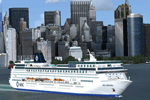
This package contains AI ship traffic files for the US East Coast to be used with my packages "63 AI Ships and AI Ship Traffic for Europe and South America" and "75 AI Ships and AI Ship Traffic". With the three packages installed you will have a total of 138 ships travelling along the US East Coast from Fort Lauderdale to the Gulf of St. Lawrence.
The ships visit among other places Fort Lauderdale, Freeport, Jacksonville, Savannah, Charleston, Wilmington, Norfolk, Baltimore, Philadelphia, New York, Boston, Portland, Providence, Halifax, Saint Pierre et Miquelon and more.
To make this package work you must first download and install in this sequence:
"63 AI Ships and AI Ship Traffic for Europe and South America",
"75 AI Ships and AI Ship Traffic", and
"Patch for 75 AI Ships and AI Ship Traffic" (If you install this patch you do not need the "Patch for 63 AI Ships and AI Ship Traffic")
This package has been developed with contributions from among others Jean-Pierre Fillion, Didier "Lagaffe" Puentes and "Robystar". I would like to thank these three as well as everybody who have encouraged and supported the project or participated in the beta testing.
| Filename: | ai_ship_traffic_for_us_east_coast_v1.zip |
| License: | Freeware |
| Added: | 1st September 2013, 08:47:12 |
| Downloads: | 8,338 |
| Author: | Henrik Nielsen |
| Size: | 1.08 MB |
| Category: Flight Simulator X - Scenery | |
| Duxford Airfield Scenery for FSX SP2/Acceleration |
|
Images related to this file:
File Description:
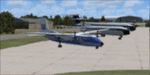
Scenery for Duxford Airfield, Cambridgeshire, UK, home of Imperial War Museum Duxford. This scenery includes almost all of the buildings, and ample parking for AI. It also includes flightplans to set up two resident dragon rapide aircraft and museum aircraft on the ramp. Many thanks to David Garwood for his help, and the use of his custom buildings. Further downloads are required-please see readme for details. Designed for the default scenery, feedback when it is used with products like UTX Europe, Justflight VFR or Genx would be appreciated.
| Filename: | taduxford1.1.zip |
| License: | Freeware, limited distribution |
| Added: | 11th April 2011, 05:49:28 |
| Downloads: | 1,467 |
| Author: | Tom Arnold |
| Size: | 953 KB |
| Category: Flight Simulator X - Scenery | |
| TNCA |
|
File Description:
Queen Beatrix International Airport (IATA: AUA, ICAO: TNCA) (Papiamento: Aeropuerto Internacional Reina Beatrix), in Oranjestad, Aruba, is an aviation facility. It has flight services to the United States, most countries in the Caribbean, the northern coastal countries of South America, Canada and some parts of Europe, notably the Netherlands. It was named after Queen Beatrix of the Netherlands, the head of state of Aruba.
This file has the right coordenates, with the apron and characteristics of the airport, working jetways. The runways and runways were resized the gates placed on correct location.
| Filename: | tnca_287447.zip |
| License: | Freeware |
| Added: | 14th April 2011, 02:14:09 |
| Downloads: | 1,881 |
| Author: | Anwar Gonzalez |
| Size: | 30 KB |
| Category: Flight Simulator X - Scenery | |
| Caribbean AI Ship Traffic for 63 AI Ships |
|
Images related to this file:
File Description:
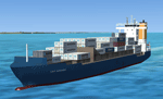
This package contains traffic files for the Caribbean Sea for the ships included in my package "63 AI Ships and AI Ship Traffic for South America and Europe V1". The new AI Ship routes are mainly concentrated in the Eastern part of the Carribbean along the Antilles from Puerto Rico to Tobago, but routes also include Panama, Colombia, Venezuela, Jamaica and Florida.
You will need to download and install "ai_ships_and_ai_ship_traffic_2013_v1.zip" before you can benefit from this package. This package does not contain any ships, but just the AI routes for the Caribbean Sea.
| Filename: | carribbean_ai_ship_traffic.zip |
| License: | Freeware |
| Added: | 9th March 2013, 22:56:28 |
| Downloads: | 10,960 |
| Author: | Henrik Nielsen |
| Size: | 716 KB |
| Category: Flight Simulator X - Scenery | |
| EBCI Charleroi Brussels South Airport Update |
|
Images related to this file:
File Description:
Update for EBCI Charleroi Brussels South Airport for FSX only based on charts of July 2010 (http://beluxvacc.org/)
Features:
- the new customer terminal including Parking 11, 12, 13 and 14
- the North taxiway connecting the cust terminal to the rwy 07 holding point N1
- all other updated taxiways and parkings/gates.
- photoscenery map for ground textures including night and seasonal variations. (best blending result with UT X Europe)
- the industrial area south of the airport
- all buildings visible at dense scenery level
| Filename: | ebci_scenery.zip |
| License: | Freeware |
| Added: | 8th February 2011, 15:33:29 |
| Downloads: | 7,313 |
| Author: | Thibault Dosunmu |
| Size: | 114.44 MB |
| Category: Flight Simulator X - Scenery | |
| Doel PowerPlant Antwerp |
|
File Description:
Doel PowerStation (Nuclear power plant) Belgium.
EB00 (zero-zero)
The Power plant of Doel NW of Antwerp is one of the major landmarks for the southwest of the Netherlands and the northwest of Belgium.
The Powerplant is so huge that it’s plainly visible from EHLE (Lelystad) at 1500ft, about 150 -200 kilometers north in reality.
This scenery not only places the power plant correct in FSX corrected for Ultimate terrain X Europe, but it also adds several ships on the Schelde river and in port.
Have fun and happy landings.
| Filename: | eb00_doel.zip |
| License: | Freeware, limited distribution |
| Added: | 13th January 2009, 14:28:30 |
| Downloads: | 3,031 |
| Author: | Joost Visser / ADE |
| Size: | 285 KB |
| Category: Flight Simulator X - Scenery | |
| EBLG Liege Bierset Airport Update |
|
Images related to this file:
File Description:
Update for EBLG Liege Bierset Airport for FSX only based on charts of July 2010 (http://beluxvacc.org/)
Features :
- the North Parking area with 10 cargo parking spaces (heavy)
- the General Aviation area north of the airport including 2 functional helipads (landing only)
- all updated taxiways (e.g. addition of N0 and C0) and parkings/gates.
- photoscenery map for ground textures including night and seasonal variations. (best blending result with UT X Europe)
- updated ILS frequencies for rwy 05R (108.75) and 23L (109.35) based on AIRAC cycle 1101 which makes both runways available for ILS approach and/or autoland.
| Filename: | eblg_scenery.zip |
| License: | Freeware |
| Added: | 19th January 2011, 00:26:51 |
| Downloads: | 6,080 |
| Author: | Thibault Dosunmu |
| Size: | 105.84 MB |
| Category: Flight Simulator X - Scenery | |
| TNCA - Queen Beatrix Intl. Airport (Aruba) |
|
File Description:
Queen Beatrix International Airport (IATA: AUA, ICAO: TNCA), in Oranjestad, Aruba, is a fairly large aviation facility that has
flight services to the United States, most countries in the Caribbean, the northern coastal countries of South America and some parts
of Europe, notably the Netherlands. It was named after Queen Beatrix of the Netherlands, the head of state of Aruba.
This airport used to serve as the hub for bankrupt airline Air Aruba, which was for many years an international airline.
Before Aruba's separation from the Netherlands Antilles in 1986 it was also one of three hubs for Air ALM. The airport has
a new airline, Tiara Air and Aruba Airlines.
| Filename: | tnca.zip |
| License: | Freeware |
| Added: | 22nd April 2009, 07:15:26 |
| Downloads: | 2,293 |
| Author: | Daniel Louvet |
| Size: | 1.8 MB |
| Category: Flight Simulator X - Scenery | |
| St KILDA upgrade for ORBX SCOTLAND |
|
File Description:
ST KILDA is an archipelago situated 41miles West of the Outer Hebrides.It is a world heritage site.
Its islands with their exceptional cliffs and sea stacks form the most important seabird breeding station in north-west Europe. The evacuation of its native population in 1930 brought to a close an extraordinary story of survival.
This scenery upgrades the ORBX scenery with the addition of -BORERAY Island and its two stacks (highest in the UK), Levenish, many birds, scenery added to HIRTA(the main island) and boat traffic.
Sadly no airfield but as Hirta has a military prescence there is a helicopter pad. This is an ideal place to explore with a floatplane!
| Filename: | st_kilda_363142.zip |
| License: | Freeware |
| Added: | 9th July 2017, 19:11:50 |
| Downloads: | 277 |
| Author: | john watts |
| Size: | 5.47 MB |
| Category: Flight Simulator X - Scenery | |
| Gustavo Rojas Pinilla International Airport (SKPS) 2011 |
|
File Description:
Gustavo Rojas Pinilla International Airport (IATA: ADZ, ICAO: SKSP) is the leading airport in the archipelago of San Andres, Providencia and Santa Catalina, which has enough capacity to receive large aircraft, due to a number of
charter flights and seasonal in different parts of America and Europe.
This file has the right coordinates, with the apron and characteristics of the airport. The runways were reoriented to the correct direction, runway were re-sized the gates placed on correct location and number, FAC was placed
(Colombian Air force and Colombian National Army) all the airport charts required to navigate in and out of this airport can be found at www.aerocivil.gov.co/ under Informacion Aeronautica click AIP; on AIP
click Aerodromos then click at SKSP.
| Filename: | sksp.zip |
| License: | Freeware |
| Added: | 23rd August 2011, 02:26:49 |
| Downloads: | 1,653 |
| Author: | Anwar Gonzalez |
| Size: | 10 KB |
© 2001-2025 AVSIM Online
All Rights Reserved