
Where Flight Simulation Enthusiasts Gather from Around the World!
AVSIM Library - Search Results

| Category: Flight Simulator X - Scenery | |
| Rio Vista Municipal Airport, California (O88) |

|
Images related to this file:
File Description:
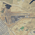
Rio Vista Municipal Airport, is located on the western edge of the city of Rio Vista in the heart of California's San Joaquin River Delta, about 260 mile northeast of San Francisco. Rio Vista Municipal Airport has an 4,200-foot long, 75-foot wide primary runway. There is also a 2,200-foot long, 60-foot wide secondary runway and a helipad. This is a major overhaul of the default airport, dramatically improving accuracy of taxiways, runways, aprons, structures and other scenery details. Designed so that anyone familiar with the actual airport will experience immediate recognition, the project includes several custom buildings and many custom scenery objects modeled on the actual airport. The surrounding area has been extensively modeled. Including, 324 accurately place wind turbines, 3690 houses, and a total count of 4740 scenery objects.
| Filename: | Rio_Vista_Municipal_Airport_California_O88.zip |
| License: | Freeware |
| Added: | 5th December 2011, 21:26:45 |
| Downloads: | 943 |
| Author: | John Hottel |
| Size: | 19.21 MB |
| Category: Flight Simulator X - Scenery | |
| Death Valley National Park - California, USA |
|
Images related to this file:
File Description:
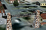
FSX Scenery--Death Valley. This scenery covers several areas of Death Valley National Park (CA). See the World's lowest golf coarse at Furnace Creek Ranch, the moving rocks at the RaceTrack, Scotty's Castle, Panamint Spring, and Stovepipe Wells. Custom designed buildings with photorealistic textures, night textures, and satellite image for the grounds. This scenery has been tested on FSX Gold Edition (FSX Deluxe and Acceleration Expansion Pack), FSGenesis 9.6 terrain mesh, and Win7 operating system. Requires RWEOBJv5.zip & RWEOBJc5.zip (or later) Object Libraries. By Ron Ezra.
| Filename: | Death_Valley_National_Park__California_USA.zip |
| License: | Freeware |
| Added: | 13th January 2016, 22:23:10 |
| Downloads: | 456 |
| Author: | Ron Ezra |
| Size: | 5.53 MB |
| Category: Flight Simulator X - Scenery | |
| KLVK - Livermore Municipal Airport - California, USA |
|
Images related to this file:
File Description:
FSX Scenery - Livermore Municipal Airport (IATA: LVK, ICAO: KLVK) is in Livermore, California, USA, east of San Francisco Bay. The airport is three miles northwest of the downtown area. Near the 650-acre airport are the Water Reclamation Plant and the Las Positas Golf Course. There are two parallel asphalt runways. The main lighted runway is 5,250 ft long and the second runway, unlighted, built in 1985, is 2,700 ft long is used mainly for training. Besides the 2,400 sq ft Terminal building, built in 1969, there are nearly 400 aircraft storage hangar units as well as a corporate-style hangar building containing 20,000 sq ft of space along with an aircraft storage shelter. About 600 aircraft are based on Livermore Airport. For your flying pleasure by John B. Loney, Jr.
| Filename: | KLVK__Livermore_Municipal_Airport____California_US.zip |
| License: | Freeware, limited distribution |
| Added: | 17th July 2015, 17:12:03 |
| Downloads: | 365 |
| Author: | John B. Loney, Jr. |
| Size: | 10.81 MB |
| Category: Flight Simulator X - Scenery | |
| Bryant Field |
|
Images related to this file:
File Description:

Bryant Field (O57) is a small field in Bridgeport, California nestled in the mountains at about 6,500 feet. The scenery includes ground polygons, seasonal aerial imagery, autogen, and AI.
| Filename: | Bryant_Field.zip |
| License: | Freeware |
| Added: | 20th December 2011, 19:26:53 |
| Downloads: | 633 |
| Author: | Kobbe Farwick |
| Size: | 78.64 MB |
| Category: Flight Simulator X - Scenery | |
| California Central Coast with Megascenery Earth and FSGenesis Mesh |
|
Images related to this file:
File Description:
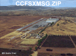
California Central Coast Scenery for FSX with Megascenery Earth and FSGenesis mesh. CCFSXMSG.ZIP covers the California coastal region from N36° 10' (Coalinga) to N34° 25' (Santa Barbara) and from the coast East to W119° 40'. It is a version of my previously created California Central Coast scenery redesigned and expanded to work with FSX MegaScenery Earth and FSGenesis USA Terrain Mesh for FSX V2 by Justin Tyme. Airstrips in the area covered by this scenery have been added for a total of 27 airports and airstrips. 6 imaginary water runways are also added for AI float plane traffic. Several other areas of interest such as the Santa Barbara marina, Morro Bay, etc. are included for a total of 41 points of interest. All airports, airstrips and related structures have been adjusted and realigned to conform to actual positions and dimensions as indicated by the MegaScenery Earth satellite textures. Megascenery Earth California-13, -14 and -15 are required and -12, -28 and -29 are recommended. By Al Wheeler 9/25/09.
| Filename: | California_Central_Coast_with_Megascenery_Earth_an.zip |
| License: | Freeware |
| Added: | 7th January 2010, 19:54:57 |
| Downloads: | 870 |
| Author: | Al Wheeler |
| Size: | 8.13 MB |
| Category: Flight Simulator X - Scenery | |
| KKIC - Mesa Del Rey Airport - California, USA |
|
Images related to this file:
File Description:
FS2004/FSX Scenery - Mesa Del Rey Airport (IATA: KIC, ICAO: KKIC, FAA LID: KIC) is a city owned, public use airport located one nautical mile (2 km) northeast of the central business district of King City, in Monterey County, California, United States. It is included in the National Plan of Integrated Airport Systems for 2011–2015, which categorized it as a general aviation facility. This was a quickie design to test how things worked under Windows 10. Nothing fancy, but enjoyable. For your flightsimming pleasure by John B. Loney, Jr.
| Filename: | KKIC__Mesa_Del_Rey_Airport__California_USA.zip |
| License: | Freeware, limited distribution |
| Added: | 20th July 2016, 09:05:10 |
| Downloads: | 417 |
| Author: | John B. Loney, Jr. |
| Size: | 23.97 MB |
| Category: Flight Simulator X - Scenery | |
| KLGB - Long Beach Airport, California, USA v5 |
|
Images related to this file:
File Description:
FSX/P3DV2: Version 5 of the Long Beach Airport scenery uploaded earlier. This version updates objects to improve performance, fixes issues with ver4, and offers improvements in certain object renderings. Version 5 is a recommended update and requires a fresh install. Users should delete ver4.
| Filename: | KLGB__Long_Beach_Airport_California_USA_v5.zip |
| License: | Freeware, limited distribution |
| Added: | 15th June 2014, 16:44:12 |
| Downloads: | 5,620 |
| Author: | Shehryar Ansari |
| Size: | 77.55 MB |
| Category: Flight Simulator X - Scenery | |
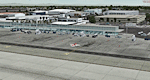
| KLAX - Los Angeles International Airport - California - USA |
|
Images related to this file:
File Description:
This is a reasonably accurate and up-to-date version of Los Angeles Intl airport and made only for FSX users, do not use in P3D: Assigned parking now updated as per their website where possible, at TBIT only the A380 gates are assigned to the airlines that use A380's so their other aircraft will also use these gates, the rest of the gates at TBIT are random parking with plenty of overflow parking included, runway lengths corrected, taxiways and taxi signs updated to the latest charts, extra fuel trucks, support vehicle roads rebuilt, and many other scenery objects and improvements added, airport views are from inside the control tower (when in tower view) please view the readme before installation.
| Filename: | KLAX__Los_Angeles_International_Airport__Californi.zip |
| License: | Freeware, limited distribution |
| Added: | 30th May 2019, 04:32:55 |
| Downloads: | 47,401 |
| Author: | Ray Smith |
| Size: | 2.74 MB |
| Category: Flight Simulator X - Scenery | |
| KSFO - San Francisco Intl - California, USA * UPDATE* |
|
Images related to this file:
File Description:
This airport update is for KSFO with two optional files made only for FSX: one version with the Crosswind runways operating, where all 4 runways will be used for takeoff/landing and one version as the default runway operation, assigned parking as per their website including gates for the A380, new control tower, runway 1L/19R now at its new length, taxiways and taxi signs updated to the latest charts, extra fuel trucks, support vehicle roads rebuilt and many other scenery improvements added, airport views are from inside the new control tower (when in tower view) please view the readme before installation
| Filename: | KSFO__San_Francisco_Intl__California_USA___UPDATE.zip |
| License: | Freeware, limited distribution |
| Added: | 27th May 2016, 05:31:35 |
| Downloads: | 42,354 |
| Author: | Ray Smith |
| Size: | 2.06 MB |
| Category: Flight Simulator X - Scenery | |
| KHAF - Half Moon Bay Airport - San Mateo County, California - USA |
|
Images related to this file:
File Description:
FSX Scenery - Half Moon Bay Airport (IATA: HAF, ICAO: KHAF, FAA LID: HAF) is a county-owned public use airport in San Mateo County, California, United States. It is located five nautical miles (9 km) northwest of the central business district of Half Moon Bay, California. The airport is on the Pacific Coast, south of San Francisco. The Half Moon Bay Airport is located approximately 20 miles south of San Francisco. It was constructed by the California State Highway Department for the U.S. Army in 1942 as an auxiliary airfield for Salinas Army Air Base. Following the end of World War II, San Mateo County acquired the airport from the Navy in 1947. The airport has served a variety of roles over the years and is currently an important business, transportation and emergency service asset to the community. For your flying pleasure by John B. Loney, Jr.
| Filename: | KHAF__Half_Moon_Bay_Airport__San_Mateo_County_Cali.zip |
| License: | Freeware, limited distribution |
| Added: | 5th August 2015, 18:57:47 |
| Downloads: | 917 |
| Author: | John B. Loney, Jr. |
| Size: | 10.69 MB |
© 2001-2026 AVSIM Online
All Rights Reserved
Privacy Policy |