
Where Flight Simulation Enthusiasts Gather from Around the World!
AVSIM Library - Search Results

| Category: Flight Simulator X - Scenery | |
| AI Ships and AI Ship Traffic US West Coast |

|
Images related to this file:
File Description:
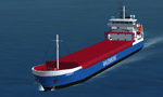
This file includes 4 new ships to supplement the ships available in my package "63 AI Ships and AI Ship Traffic for Europe and South America".
It also includes traffic files for the West Coast of the United States mainly from San Francisco and Oakland to the Strait of Juan de Luca, Tacoma, Seattle, and the Canadian cities of Victoria and Vancouver. A few routes go further South to Long Beach and San Diego. The traffic files utilize the new ships available in this update as well as the ships available in "63 AI Ships and AI Ship Traffic for Europe and South America" which must therefore be installed prior to this update.
The new ships are two small bulk carriers "Sardius" and "Andre W" and two large geared bulk carriers "Senorita" and "Carmencita" all done in GMAX. All ships have navigation lights, simple animations like rotating radars, and custom wake and smoke effects.
| Filename: | ai_ships_and_ai_ship_traffic_us_west_coast.zip |
| License: | Freeware |
| Added: | 30th March 2013, 23:18:57 |
| Downloads: | 10,961 |
| Author: | Henrik Nielsen |
| Size: | 2.47 MB |
| Category: Flight Simulator X - Scenery | |
| YBMC - Maroochydore (Sunshine Coast) Airport - Queensland, Australia **With Corrections** |
|
File Description:
With his permission this is Martin Hiesboeck's airport layout file (AFCAD) for the default FSX YBMC Maroochydore (Sunshine Coast) Airport in Queensland, Australia with two changes. (ATIS changed to 119.5MHz due to conflict with CTR freq 119.8 and Primary Rwy set to 36/18).
It features an enlarged apron, additional asphalt surfaces to accommodate the FSX default buildings, corrected gate numbers, jetways (which aren't there in reality - you can turn them off by reducing scenery complexity), added parking areas and vehicle pathways.
The runway is configured for noise abatement procedures usually in place: Landing RWY 36, Takeoff RWY 18 for all jets, such as not to disturb the sunseekers on the beach. Gate assignments are incomplete. Tested with WoAI AI only.
Original file uploaded by Martin Hiesboeck named ybmc_mh.zip with changes and renamed ymbc_mh2.zip.
| Filename: | ybmc_mw2.zip |
| License: | Freeware |
| Added: | 11th March 2015, 13:55:08 |
| Downloads: | 427 |
| Author: | Simon Hitch, Martin Hiesboeck |
| Size: | 115 KB |
| Category: Flight Simulator X - Scenery | |
| Watsonville Municipal Airport (KWVI) |
|
File Description:
This is a scenery update for Watsonville Municipal Airport in Watsonville, California. Taxiways, runways, building positions, and other aspects were updated using satellite images from Google Earth for accuracy. Many default scenery objects from the FSX libraries were used. View Readme file for installation and notes. Compiled using Airport Design Editor.
| Filename: | kwvi_scenery.zip |
| License: | Freeware |
| Added: | 17th October 2008, 09:52:09 |
| Downloads: | 896 |
| Author: | Phillip Coyle |
| Size: | 236 KB |
| Category: Flight Simulator X - Scenery | |
| Banning Airport KBNG FSX |
|
File Description:
Jim Dhaenen's airport buildings and Cal Classic libraries required. Banning is a single-runway general aviation field next to Interstate 10 in Banning, California, in between Redlands and Palm Springs.
I corrected taxiways, runway dimensions, and ramps and added more realistic hangars, the new fueling area, and more realistic parking spots.
| Filename: | banning_fsx.zip |
| License: | Freeware |
| Added: | 20th February 2024, 14:38:32 |
| Downloads: | 68 |
| Author: | Lazerson |
| Size: | 1.84 MB |
| Category: Flight Simulator X - Scenery | |
| North Central Ecuador v3, including SEQM (SEQU) and SEIB |
|
Images related to this file:
File Description:
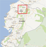
FSX/P3D Version 3 of this scenery is a completely new build of SEQM from the ground up. The entire complex is rendered using FSX objects along with the new highway that connects to the highway infrastructure with AI road traffic. The airport is now at a mean altitude that better blends with the newly included NASA SRTM GL1 30m mesh for the region. The tower is at the correct altitude. Buildings use more accurate footprints, new models, floating jetways, and updated landclass, and work seamlessly with the roads added by FTX Global/Vector. Lakes are corrected within roughly 100 square miles. Although the Ibarra/Atahualpa (SEIB) airport no longer exists, there is an option to add it back. Startup files are included to fly from the lakes and the Ibarra/Atahualpa (SEIB) airport. As a “bonusâ€, SEQU was restored in this version, because much of the footprint of the airport still remains as part of its conversion to a park. As such, a custom and fully functional SEQU is included for users who would like to revisit the old airport. AI Traffic can be restored at SEQU by simply using the "Reversed SEQU-SEQM AI Traffic" option. Scenery was created using Airport Design Editor X v1.76.6715, SBuilderX 3.13, and the FSX Object Placement Tool. Scenery objects were added and modified from stock FSX scenery to resemble as closely as possible the actual airport. Bill Leaming's Ramp Lights for P3D/FSX illuminate the aprons.
| Filename: | north_central_ecuador_v3.zip |
| License: | Freeware |
| Added: | 22nd March 2020, 22:13:37 |
| Downloads: | 3,894 |
| Author: | Carlyle Sharpe |
| Size: | 29.4 MB |
| Category: Flight Simulator X - Scenery | |
| Catalina Island |
|
File Description:
This little addon gives more to look at when flying by or to Catalina Island in Southern California (west of Los Angeles). It includes a dock filled with boats, a yacht, ferry, dolphins, an oil rig, and more. For more of my scenery or questions, comments etc. please visit my website: freewebs.com/dsaddons
| Filename: | catalina_island_fsx_scenery.zip |
| License: | Freeware |
| Added: | 26th November 2008, 08:12:51 |
| Downloads: | 3,080 |
| Author: | Derek Souza |
| Size: | 1.93 MB |
| Category: Flight Simulator X - Scenery | |
| Kwinamass River dirt strips |
|
File Description:
Dirt strips and seaplane docks between Prince Rupert CYPR and Nass Bay along the beautiful north coast of British Columbia. Great fun flying for Challenger Ultralight and small bush planes. For use with Ultimate Terrain Canada FSX only. Freeware by Doug Keech.
| Filename: | kwinamass_river.zip |
| License: | Freeware |
| Added: | 21st December 2008, 08:38:49 |
| Downloads: | 883 |
| Author: | Doug Keech |
| Size: | 1012 KB |
| Category: Flight Simulator X - Scenery | |
| Alaskan Air Cargo |
|
File Description:
This adds a small airport to the coast of Akutan, Alaska. Complete with parking spots, buildings, cargo. Also inludes ATC and ATIS services. This is my first attempt to create an airport This airport was made with AFCAD2 and with Abacus' Scenery Shortcut.
| Filename: | alaskan_air_cargo.zip |
| License: | Freeware, limited distribution |
| Added: | 30th June 2007, 15:15:49 |
| Downloads: | 1,593 |
| Author: | Pedro Vendeira |
| Size: | 1.11 MB |
| Category: Flight Simulator X - Scenery | |
| Belgium, The West Flanders - autogen V1 |
|
File Description:
Belgium. The West Flanders.
For scenery photo of BELGIUM.
The entire Belgian coast.
From Courtrai to Bruges, included Oostende, De Panne.
surrounding EBFN, EBOS, EBZU, EBUL EBMO, EBKT.
Autogen vegetation 80% and the largest buildings of its surrounds. 2181 agn
| Filename: | belgium-the-west-flanders_-autogen-v1.zip |
| License: | Freeware, limited distribution |
| Added: | 8th June 2012, 20:50:43 |
| Downloads: | 2,932 |
| Author: | Dominique Dziedziczak |
| Size: | 3.61 MB |
| Category: Flight Simulator X - Scenery | |
| St Tammany Regional Airport - L31 |
|
File Description:
St. Tammany Regional Airport (FAA LID: L31) is a public use airport in St. Tammany Parish, Louisiana, United States. It is owned by St. Tammany Parish and located six nautical miles (11 km) southeast of the central business district of Covington, Louisiana. The nearest town is Abita Springs.
| Filename: | st_tammany_regional_airport_l31.zip |
| License: | Freeware |
| Added: | 1st December 2013, 21:25:48 |
| Downloads: | 304 |
| Author: | Rob Meier |
| Size: | 2.48 MB |
© 2001-2025 AVSIM Online
All Rights Reserved