
Where Flight Simulation Enthusiasts Gather from Around the World!
AVSIM Library - Search Results

| Category: Flight Simulator X - Scenery | |
| Detailed Terrain Features for Southern Africa, Update 9 |

|
Images related to this file:
File Description:

Scenery consist of Updated Terrain Vector data concerning Coastlines, rivers, dams, lakes, streams, roads, traffic, railroads, power lines and extrusion bridges for Southern African countries South of the Equator. A lot of work was done from the East Coast at Dar Es Salaam, west towards the Great Lakes in the Rift Valley like Lake Malawi, Lake Tanganyika, Lake Rukwa, Zambia and the Republic of the Congo and as far down as Lusaka and the Kafue swamps. Some work was also done around Robertson in the Cape and some around Ceres, With this scenery it is important to install the previous release of "fsxWorx01" and updates 1 to 8 before this file.
| Filename: | Detailed_Terrain_Features_for_Southern_Africa_Upda.zip |
| License: | Freeware |
| Added: | 19th March 2014, 22:12:43 |
| Downloads: | 2,223 |
| Author: | Hannes Steyn, Aeroworx |
| Size: | 4.79 MB |
| Category: Flight Simulator X - Scenery | |
| Whole Ghana,Togo and Benin ,Soaring Scenery |
|
File Description:
FSX/2004/FS2002 Whole Ghana,Togo and Benin ,Soaring Scenery
This file adds thermals lifts to glider´s flights over Whole Ghana,Togo and Benin Regions,Africa
It is freeware.Good Flights and better Landings
Volta Redonda,Brazil,05/01/2008
It is freeware
Design:Francisco Vargas. E-mail:[email protected]
| Filename: | ghatobe.zip |
| License: | Freeware |
| Added: | 2nd May 2008, 02:28:52 |
| Downloads: | 311 |
| Author: | Francisco Augusto Vargas Carneiro |
| Size: | 1.28 MB |
| Category: Flight Simulator X - Scenery | |
| Algiers Real Scenery X |
|
Images related to this file:
File Description:
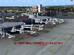
FSX Algiers Real Scenery by Riad GHENIM.
Algiers, DAAG Algeria Houari Boumedienne Airport. One of the biggest airport in Africa.
This scenery contains animated jetways, photoreal ground textures and new parking marks.
It works also with Algiers City X - PhotoTerrain FSX scenery. This scenery needs SP2 or FSX Acceleration.
| Filename: | daagrealsceneryx.zip |
| License: | Freeware |
| Added: | 3rd June 2011, 22:30:00 |
| Downloads: | 32,697 |
| Author: | Riad Ghenim |
| Size: | 21.64 MB |
| Category: Flight Simulator X - Scenery | |
| Matekane Airfield V2 (FXME) Part 1 |
|
Images related to this file:
File Description:
Matekane airfield is a very small airfield and is located in South Africa in Lesotho.
You could to say a dangerous airfield.
This Scenery is designed for FSX sp2/Acc + DX10. This Scenery has Grass animation, animals and sounds. An video can find by youtube: /watch?v=9K4fOxgMfYk
Have Fun =)
| Filename: | matekane_airfield_v2_fxme_part_1.zip |
| License: | Freeware |
| Added: | 21st April 2011, 23:31:11 |
| Downloads: | 2,694 |
| Author: | Ulukan Zafer |
| Size: | 164 MB |
| Category: Flight Simulator X - Scenery | |
| Moshoeshoe International Airport (FXMM) |
|
Images related to this file:
File Description:
This is Moshoeshoe International Airport in Lesotho Africa the mountain kingdom. It is completely custom designed with Custom terminals, hangars and admin buildings. It also has a custom AFCAD file a photoreal background that changes with the seasons. FSX Acceleration will give the best results.(Also SP2 compatible). Acceleration users will have more eye candy!
| Filename: | moshoeshoe.zip |
| License: | Freeware |
| Added: | 29th April 2011, 16:26:35 |
| Downloads: | 1,691 |
| Author: | Jacques Botha, Frits Beyer |
| Size: | 5 MB |
| Category: Flight Simulator X - Scenery | |
| FDMS - Matsapha International Swaziland |
|
Images related to this file:
File Description:
Matsapha International airport in Swaziland.Made from completely custom designed models and textures. It has a photo real base that changes with the seasons. One of the Kingdom of Swaziland's main busiest airports with regular flights to South Africa. FSX Acceleration will give the best results. (Also SP2 compatible). Acceleration users will have more eye candy!
| Filename: | matsapha.zip |
| License: | Freeware |
| Added: | 1st June 2011, 00:55:36 |
| Downloads: | 2,116 |
| Author: | Frits Beyer and Jacques Botha |
| Size: | 12.85 MB |
| Category: Flight Simulator X - Scenery | |
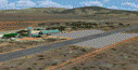
| Upington Airport South Africa_FAUP |
|
File Description:
This is Upington Airport in South Africa.It has the longest runway in Southern Africa and is a emergency landing option for NASA's Space Shuttle.The airport is used for tourism in the Northern Cape and mainly for cargo exports.It is also a storage airport for unused airliners and other aircraft.Made from custom designed buildings and for FSX only !
| Filename: | faup_upington.zip |
| License: | Freeware |
| Added: | 8th April 2009, 19:20:42 |
| Downloads: | 1,026 |
| Author: | Jacques Botha |
| Size: | 982 KB |
| Category: Flight Simulator X - Scenery | |
| Ship in Distress for FSX and FS2004 |
|
File Description:
Ship is a cargo vessel, on fire and crew need airlifting. Lying a couple of miles west of Robben Island, Cape Town, South Africa. It is fitted with a landable helipad in the stern and has lights for better nighttime ops.
Coordinates S33 48.12 E18 15.50
Made with GMAX by Johan Kotze.
Includes FS2004 and FSX files.
| Filename: | shipdistress.zip |
| License: | Freeware |
| Added: | 21st April 2015, 21:40:22 |
| Downloads: | 288 |
| Author: | Johan Kotze |
| Size: | 1.03 MB |
| Category: Flight Simulator X - Scenery | |
| Roodewal Weapons Test Range-FARW |
|
Images related to this file:
File Description:
FSX/P3Dv3 Photo real scenery of the shooting area: Roodewal weapons test range in the north east of South Africa, it content of an airfield FARW with a 38x2390 runway, and some homemade buildings, shooting target, some animated tanks and missile launchers. I have made the scenery after a request from Willie a South African flight-simmer.
Otto Knudsen
| Filename: | fsx-p3dv3_roodewal_weapons_test_range_farw.zip |
| License: | Freeware |
| Added: | 30th April 2018, 17:30:58 |
| Downloads: | 351 |
| Author: | Otto Knudsen |
| Size: | 52.33 MB |
| Category: Flight Simulator X - Scenery | |
| RAF Condover |
|
File Description:
Royal Air Force Condover was a former Royal Air Force Flying Training Command airfield and air navigation training establishment between August 1942 and June 1945, unusually for both fighter and bomber crews at different times
Condover was used to train fighter pilots by the RAF and the USAAF as well as pilots and air navigators from Australia, South Africa and Canada.
| Filename: | raf_condover.zip |
| License: | Freeware |
| Added: | 5th February 2017, 18:48:08 |
| Downloads: | 123 |
| Author: | Terry Boissel |
| Size: | 5 MB |
© 2001-2025 AVSIM Online
All Rights Reserved