
Where Flight Simulation Enthusiasts Gather from Around the World!
AVSIM Library - Search Results

| Category: Flight Simulator X - Scenery | |
| Oahu Scenery Version 1 |

|
File Description:
This scenery sits on top of "MegaSceneryX - Hawaii - Honolulu and Oahu Island", SO IT REQUIRES THE MEGASCENERY X - Hawaii - Honolulu & Oahu Island" photo scenery from http://www.megascenery.com/
This is primarily an Autogen scenery with some custom developed objects for the coast of Oahu.
I used autogens from default FSX for the most part as well as the FSX Acceleration. IF you did not install acceleration, it should not be an issue. you would just not see some of the autogens from the acceleration package. I have also included some custom built GMAX Objects with this package. There is also an AFCAD file for a new fictitious Heliport that is included ("PMMH)".
This scenery package also includes a Mission called "Oahu Sacred Falls Landing". It is a short mission without any surprises or twists, yet I am confident many of you would find it interesting and very very challenging. But do not be discouraged at the difficulty of completing the mission. You may want to turn off crash detection to make it easier if you'd like. The fun is in the journey..right?
Lastly, I have included a fix for my MM_PHNGv1 scenery as part of this package.
| Filename: | Oahu_Scenery_Version_1.zip |
| License: | Freeware, limited distribution |
| Added: | 29th February 2008, 02:31:04 |
| Downloads: | 4,125 |
| Author: | Manny Mahadevan |
| Size: | 9.9 MB |
| Category: Flight Simulator X - Scenery | |
| RAF Wickenby (1940s) |
|
File Description:
RAF Wickenby was a purpose built Royal Air Force station constructed late 1942 and early 1943 it had two T2 type
hangars and one B1 type. The B1 and one of the T2 hangars can still be seen on the airfield site. The T2 near the
threshold of runway 21 was recently acquired by the airfield owners and after many years of industrial use is now,
once more, an aircraft hangar.
The airfield covered about 600 acres (2.4 km2), and had the usual three runway configuration with perimeter track,
hard standings, a brick watchtower and numerous brick and metal buildings for the aircrews and ground staff. A number
of the buildings were to the east (Communal Site, Living Quarters, WAAF Quarters) and stretched to and beyond the
Lissington road - a road travelled many an evening by the airmen and women who visited their favourite watering hole,
the White Hart at Lissington. The Sick Quarters were to the south of the airfield together with a Communal Site and
Living Quarters.
The north part of the former airfield is now known as Wickenby Aerodrome, which is a grass and concrete airfield. A
road from Holton cum Beckering to Snelland runs right over the former airfield. Companies based at the airfield are
Thruster Aircraft who make microlight planes; Fly365 Ltd who fly pleasure flights; and Rase Distribution - a haulage
firm. Planes using the airfield have to make contact first with the control tower at RAF Waddington.
The Watch Office is the home of the RAF Wickenby Memorial Collection and the Wickenby Archive, a museum and collection
of memorabilia and archive dedicated to the memory of the Squadrons who served here.
| Filename: | RAF_Wickenby_1940s.zip |
| License: | Freeware |
| Added: | 10th March 2017, 14:46:25 |
| Downloads: | 136 |
| Author: | Terry Boissel |
| Size: | 15.14 KB |
| Category: Flight Simulator X - Scenery | |
| RAF Predannack |
|
File Description:
RAF Predannack was opened in May 1941 as a satellite for RAF Portraits. Accommodation was dispersed over a wide area, with officers accommodated in the Mullion Cove and Polurian Hotels. The number of personnel reached peak strength of 3,600 by 1944.
The first squadron to arrive was 247 Squadron with Hawker Hurricanes, specialising in night defence of the South West's towns and ports. The night fighting element was later augmented by 1457 Flight flying Douglas Havocs with its unsuccessful Turbinlite searchlight tactics. However, the arrival of 600 Squadron with radar equipped Bristol Beaufighters produced better results. GCI (Ground Control Interception) in the area was covered by RAF Treleaver radar station.
A more detailed history can be found on Wikipedia.
| Filename: | RAF_Predannack.zip |
| License: | Freeware |
| Added: | 18th May 2017, 14:39:04 |
| Downloads: | 93 |
| Author: | Terry Boissel |
| Size: | 3.14 MB |
| Category: Flight Simulator X - Scenery | |
| TACAN Replacements, Waypoints & Routes - UK Modern |
|
File Description:
By default, all of the TACAN navigational aids present within FSX have the bearing component turned off, so as to properly represent the real world result of tuning in the DME component of a TACAN with a civilian plane. However, this limits their functionality when you wish to use them in conjunction with a plane (generally military) equipped with a representation of a functioning TACAN system.
This download contains replacements for all of the currently active TACAN ground stations present in the UK, along with custom TACAN route waypoints as well as UK MIL AIP documentation and maps. These allows the user to fly the TACAN routes as per real world operations, as well as use TACAN approach charts.
| Filename: | TACAN_Replacements_Waypoints__Routes__UK_Modern.zip |
| License: | Freeware |
| Added: | 5th June 2014, 05:36:11 |
| Downloads: | 492 |
| Author: | Jim Stewart |
| Size: | 632.35 KB |
| Category: Flight Simulator X - Scenery | |
| CYUL - TSC Building Logo - FIXED |
|
Images related to this file:
File Description:
![]()
For owners of Blueprint Simulations CYUL Scenery, this will place Air Transat's logo on their maintenance building.
That building is very recognisable due to the logo, which is in proximity of Highway 13, which sees a lot of traffic. The most used approach at CYUL is 24R,and this building is located right next to it, so it will give you an even better feel that you are about to touch ground in Montreal!
Fixed the file, as i had zipped a wrong file. put CYUL_TSC_LIB.BGL instead of CYUL_TSC_LOGO.BGL.
It now works.
NOTE: This file does not alter Blueprint's files, it is completely separate, but must be put in Blueprint's CYUL directory to work. Enjoy!
| Filename: | CYUL__TSC_Building_Logo__FIXED.zip |
| License: | Freeware |
| Added: | 26th January 2010, 04:14:58 |
| Downloads: | 951 |
| Author: | Brian Paquette |
| Size: | 666.14 KB |
| Category: Flight Simulator X - Scenery | |
| PHNG-Kaneohe Bay area scenery Version 1.0 |
|
File Description:
This scenery is the PART II autogen scenery for the Island of Oahu series that I am working on, that sits on top of "MegaSceneryX - Hawaii - Honolulu and Oahu Island", SO IT REQUIRES THE MEGASCENERY X - Hawaii - Honolulu & Oahu Island" photo scenery from http://www.megascenery.com/
This Autogen scenery is around the PHNG Airport locale.
I used autogens from default FSX as well as the FSX Acceleration. IF you did not install acceleration, it should not be an issue. You would just not see some of the autogens from the acceleration package.
| Filename: | PHNGKaneohe_Bay_area_scenery__Version_10.zip |
| License: | Freeware, limited distribution |
| Added: | 29th January 2008, 20:20:18 |
| Downloads: | 3,022 |
| Author: | Manny mahadevan |
| Size: | 1.66 MB |
| Category: Flight Simulator X - Scenery | |
| Fermont - Quebec bush scenery |
|
File Description:
This scenery is fictitious and created for the pleasure of all. All the objects are already included in FSX and no other library was used. In this scenery you can observe a mining complex. In this part of the province, the weather is very cold and windy.
Must have before installing the Aerovirtuel bush flying sceneries:
1-Quebec Elevation 38m (LOD10) Gilles Gauthier sur http://avsim.com/ 5 files.
2-Quebec Scenery - Lakes and Rivers (1/5) http://avsim.com/ 5 files and one fix
3-Quebec Scenery - Addition of Roads http://avsim.com/
| Filename: | Fermont__Quebec_bush_scenery.zip |
| License: | Freeware, limited distribution |
| Added: | 9th November 2007, 22:28:06 |
| Downloads: | 1,137 |
| Author: | Denis Dupuis |
| Size: | 349.77 KB |
| Category: Flight Simulator X - Scenery | |
| Henri Mondor Hospital - France - Creteil |
|
File Description:
Henri Mondor is an hospital based in Creteil near Paris. The emergency department is equipped with an helipad where helicopters from the french EMS (SAMU) can drop quickly seriously injured persons.
Henri Mondor is the headquarter of SAMU 94 and is part of the APHP group ("Assistance Publique des Hopitaux de Paris"). About 40 000 persons are being taken care each year in this hospital.
Building designed with Gmax. Helipad and library objects added with ADE.
Nearest airport is Orly (ICAO: LFPO). Fly N-E from Orly.
Helipad fictionnal ICAO code is HHMN.
| Filename: | Henri_Mondor_Hospital__France__Creteil.zip |
| License: | Freeware |
| Added: | 2nd April 2009, 00:53:55 |
| Downloads: | 1,653 |
| Author: | Léonard Savina |
| Size: | 752.6 KB |
| Category: Flight Simulator X - Scenery | |
| Vancouver Medical Center.zip |
|
Images related to this file:
File Description:
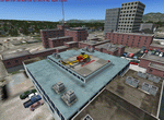
This scenery is fictional of Vancouver Medical Center. The added medical complex has 2 landable helipads. One is part of the "hospital" object and one is additional on another building at the complex. Both are landable. The complex is just south of the downtown area. Future FSX missions will utilize both these sceneries. Read the txt file for two install options. Can be installed stand-alone or by placing the bgl of this scenery into the scenery folder of "Vancouver Extras" if you downloaded that scenery. Designed to enhance your FSX world. savageagle, Enjoy!
| Filename: | Vancouver_Medical_Centerzip.zip |
| License: | Freeware |
| Added: | 19th July 2010, 00:26:07 |
| Downloads: | 536 |
| Author: | Tim Durham |
| Size: | 782.48 KB |
| Category: Flight Simulator X - Scenery | |
| Chicago Midway Intl. Airport |
|
File Description:
Chicago Midway Intl. Airport for FSX. Several improvements have beeen made, including: the addition of six jetways to now include all gates as at the real life airport; assigning all gates to specific airlines using Afcad2; Adding on to the default terminal to include gates A4A and A4B, as this part was not included in FSX; the rebuilding of vehicle paths, which prevents airport vehicles from accessing the taxiways, which can result in traffic delays; and activation of the crosswind runways. Note that this file is for FSX only. It will not work in FS9.
| Filename: | Chicago_Midway_Intl_Airport.zip |
| License: | Freeware, limited distribution |
| Added: | 27th April 2007, 00:25:36 |
| Downloads: | 3,680 |
| Author: | Patrick Finch |
| Size: | 202.48 KB |
© 2001-2026 AVSIM Online
All Rights Reserved
Privacy Policy |