
Where Flight Simulation Enthusiasts Gather from Around the World!
AVSIM Library - Search Results

| Category: Flight Simulator X - Scenery | |
| LGSK Skiathos Alexandros Papadiamantis - FIX |

|
Images related to this file:
File Description:

This is a repair fix for some textures and for full compatibility with GAP-HAS photoreal scenery that covers the entire island - we strongly recommend it!!!!! You can find it here http://www.greekairportsproject.gr/site/
| Filename: | LGSK_Skiathos_Alexandros_Papadiamantis__FIX.zip |
| License: | Freeware |
| Added: | 27th February 2011, 14:46:20 |
| Downloads: | 4,121 |
| Author: | Moraitis Vaggelis |
| Size: | 934.31 KB |
| Category: Flight Simulator X - Scenery | |
| KSDF Louisville Photo Scenery |
|
File Description:
This scenery is an FSX photo version of KSDF Louisville Intl-Standiford Field. The scenery includes night textures, revised AFCAD, additional traffic and thorough autogen. The UPS main Air Hub is located on the south half of the airport. Just south of the airport is the Ford Louisville assembly plant where the Explorers are built. The UPS facility, Ford plant, parking garage and FBO on the east side are modeled using default FSX textures. The FSX terminals have been moved to match the photo.
| Filename: | KSDF_Louisville_Photo_Scenery.zip |
| License: | Freeware |
| Added: | 7th February 2008, 01:37:30 |
| Downloads: | 4,960 |
| Author: | Kevin Burns |
| Size: | 36.95 MB |
| Category: Flight Simulator X - Scenery | |
| RNAS Anthorn (HMS Nuthatch) - Cumbria, UK |
|
File Description:
This scenery is a representation of RNAS Anthorn (HMS Nuthatch) prior to runway and taxiway upgrades completed in 1948. It is not 100% accurate and no claim is being made that it is.
The scenery was made using ADE and is intended for use in FSX along with Horizon GenX VFR scenery but should work ok in Basic FSX.
Some History: Anthorn air field (also known as RAF Anthorn, RNAS Anthorn and HMS Nuthatch) was an airfield approximately 430 KM north-northwest of London
The airfield was built in february 1918 as a Fleet Air Arm (FAA) airfield. It was abandoned after World War I ended, however. The RAF reinstated the airfield at the beginning of World War II as an emergency landing ground for nearby RAF Silloth.
The site was taken over by the Royal Navy in December 1942, and renamed the site RNAS Anthorn. It was commissioned in September 1944 as 'HMS Nuthatch'.
The airfield served as No. ARDU (Aircraft Receipt and Dispatch Unit), a unit that accepts aircraft from their manufacturers and prepares them for operational use.
The last official flight took off from the airfield in November 1957. It was then put on Care and Maintenance, before it closed down in March 1958.
In 1961 the site was chosen to become a NATO VLF transmitting site for communicating with submarines. Construction of the site, by Continental Electronics of Dallas, U.S.A., began in 1962.
The station was accepted on behalf of the MoD in November 1964.
| Filename: | RNAS_Anthorn_HMS_Nuthatch__Cumbria_UK.zip |
| License: | Freeware |
| Added: | 1st March 2015, 23:11:58 |
| Downloads: | 435 |
| Author: | Mark Byers |
| Size: | 21.34 MB |
| Category: Flight Simulator X - Scenery | |
| RAF Attlebridge - Norwich, Norfolk, England |
|
File Description:
RAF Attlebridge is a former Royal Air Force station located near Attlebridge and 8 miles (13 km) northwest of Norwich, Norfolk, England. RAF Attlebridge was an early wartime station, laid out for use by No. 2 Group RAF light bombers, and was completed in August 1942. The airfield was used by No. 88 Squadron RAF from August 1941 to September 1942 using Bristol Blenheim IVs and Douglas Bostons.
The Station had runways of 1,220, 1,120 and 1,080 yards length but, when the base was earmarked for USAAF use, these were extended and the airfield was enlarged to meet heavy bomber requirements. The main E-W runway was increased to 2,000 yards and the others to 1,400 yards each. The perimeter track was also extended and the number of hardstands was increased to fifty. In enlarging the airfield, several small, country roads were closed in the parish of Weston Longville, in which the larger part of the airfield was sited.
RAF Attlebridge was assigned to the United States Army Air Forces (USAAF) Eighth Air Force's 2nd Bomb Wing on 30 September 1942. It was given USAAF designation Station 120.
Third party add-on scenery will be required - see readme for details.
| Filename: | RAF_Attlebridge___Norwich_Norfolk_England.zip |
| License: | Freeware |
| Added: | 4th January 2016, 16:32:15 |
| Downloads: | 329 |
| Author: | Terry Boissel |
| Size: | 1.04 MB |
| Category: Flight Simulator X - Scenery | |
| Carrier CVN75_V2 North Sea |
|
File Description:
This is a update version of my scenery DL_CVN75.zip.
Changes in Version 2 of the cenery:
1.The Carrier model is now a private object and no longer part of the standard FSX object lib..
This allows the installation and registration in FSX scenery setting to be done like any
other addon objects.
The registration of the scenery in FSX below " Global, Generic & Vehicle Libraries" is no
longer required !!!!
2.Version 2 has more stuff on deck of the carrier.
3.The Number 75 is more accurate according to the real carrier.
4.The ILS frequencies ( e.g. GS) is more accurat adjusted in relation to the cable zone.
Scenery: Carrier Group North sea. Close to the Island of Sylt The Scenery includes: - The USS Carrier Harry Truman, CVN 75 with full function as an Airport with ILS approach capability.
F18-Fighters and a Navy-Heli on the Carrier. - 2 flying Helicopters over the Carrier. - 4 Navy-Destroyers escorting the Carrier. In addition to the Carrier-Group: - A Oilrig about 30 nm northwest from the Carrier. The Heli-Pat is a landable Platform !! - 2 moving Destroyer based on a "Boats Traffic Plan" which are moving around the group according to the time schedule in the plan.
| Filename: | Carrier_CVN75_V2__North_Sea.zip |
| License: | Freeware |
| Added: | 26th December 2008, 10:44:37 |
| Downloads: | 3,483 |
| Author: | Dietmar Loleit |
| Size: | 4.83 MB |
| Category: Flight Simulator X - Scenery | |
| LGKF Kefallinia / Cephalonia International Airport, Greece |
|
Images related to this file:
File Description:
LGKF Kefallinia Greece
The island of Kefalonia lies on the west coast of Greece. The nearest airports are LGZA Zakinthos, LGKR Kerkira, and LGPZ Preveza. During the tourist season the island is a very popular destination for flights from Frankfurt, Berlin, Gatwick, Rome and many others.
This scenery has been designed to sit on top of Yiannis Dermitzakis's file - grcoastlines.zip, available here on Avsim. I would also highly recommend Angelo Tassoglou's photoreal scenery called ionianislands.zip, also available here on Avsim.
The scenery has been created using real photographs where possible and has been repositioned in line with satellite imagery. It features many objects painted with Hellenic features and Mediterranean vegetation. It also includes animated flags, windsocks, vehicles, aircrew and road traffic around the airport. Full night lighting is included together with wash lighting of the apron and carparks. The scenery has been sub-divided so that each part can be switched on or off according to user preference. Traffic files are based on real schedules effective to 2013. The scenery has been designed for, and tested with FSXA only. Full installation instructions, settings, hints and tips are included.
Please enjoy and I hope you like my scenery as much as I enjoyed building it.
| Filename: | LGKF_Kefallinia__Cephalonia_International_Airport_.zip |
| License: | Freeware, limited distribution |
| Added: | 23rd December 2012, 23:10:32 |
| Downloads: | 23,224 |
| Author: | George Keogh |
| Size: | 60.33 MB |
| Category: Flight Simulator X - Scenery | |
| CVN68_Carrier_North Sea_V1 |
|
Images related to this file:
File Description:
This scenery is based on the great CVN 68 Nimitz carrier model from Javier Fernandez.
The scenery shall replace my current CVN 75 scenery in the North Sea.
The scenery includes the following scenery elements, objects and dynamic traffic:
The carrier CVN 68 Nimitz and a lot of stuff on deck, 2 flying Helicopters over the Carrier,
4 Navy-Destroyers escorting the Carrier, 2 moving Destroyer based on a "Boats Traffic Plan
which are traveling around the group, 1 moving Tanker,a Oilrig about 30 nm northwest from the Carrier with a landable Platform !!
Seven F-18 Hornets as AI traffic, three F-18 Hornets based on recorded flights.
For the re-play of the start and landing traffic, the tool FSRecorder is required. The tool is part of this scenery package.
The carrier is built up as an airport with the code " CV68 ".
For installation and more info see the documentation inside the zip file.
For full carrier operation (catapul/cable catch) you need one of the two tools: RCBCO-30.zip, or ArrCab26.zip both available at the AVSIM lib.
CREDIT goes to :Javier Fernandez for his super great carrier model and to
Matthias Neusinger for his excellent FSRecorder tool.
| Filename: | CVN68_Carrier_North_Sea_V1.zip |
| License: | Freeware |
| Added: | 2nd June 2010, 01:37:06 |
| Downloads: | 2,918 |
| Author: | Dietmar Loleit |
| Size: | 32.58 MB |
| Category: Flight Simulator X - Scenery | |
| Macedonia West - Greece |
|
Images related to this file:
File Description:
MacedoniaWest Dn
AS REAL AS IT GETS.
This is a detailed photorealistic scenery of Nomos Florinis and Edessis
WITH NIGHT TEXTURES.
There are no airports in this photoscenery. Just the landscape of
mountains, and fields.
| Filename: | Macedonia_West__Greece.zip |
| License: | Freeware |
| Added: | 24th November 2016, 17:36:30 |
| Downloads: | 732 |
| Author: | Angelo Tassoglou |
| Size: | 220.96 MB |
| Category: Flight Simulator X - Scenery | |
| Chalkidiki and Central Macedonia - Greece |
|
Images related to this file:
File Description:
Chalkidiki
AS REAL AS IT GETS.
This is a detailed photorealistic scenery of Nomos Chalkidikis, and Central Macedonia WITH NIGHT TEXTURES.
There are no airports in this photoscenery. Just the landscape of mountains, and fields.
| Filename: | Chalkidiki_and_Central_Macedonia__Greece.zip |
| License: | Freeware |
| Added: | 31st May 2016, 16:48:40 |
| Downloads: | 1,073 |
| Author: | Angelo Tassoglou |
| Size: | 220.38 MB |
| Category: Flight Simulator X - Scenery | |
| East Midlands Xtreme |
|
Images related to this file:
File Description:
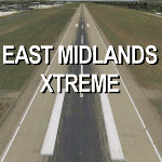
Extremely accurate scenery for East Midlands airport,UK. Includes night lighting, animation vehicles, replacement AFCAD file, High resolution base image, static and museum aircraft. All textures
made to the highest standard based on actual photographs.
| Filename: | East_Midlands_Xtreme.zip |
| License: | Commercial demo |
| Added: | 10th February 2012, 23:57:06 |
| Downloads: | 2,073 |
| Author: | Gary Summons/UK2000 Scenery |
| Size: | 89.66 MB |
© 2001-2026 AVSIM Online
All Rights Reserved
Privacy Policy |