
Where Flight Simulation Enthusiasts Gather from Around the World!
AVSIM Library - Search Results

| Category: Flight Simulator X - Scenery | |
| 52F North West Regional Airport (DFW TX) |

|
Images related to this file:
File Description:
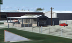
This airport scenery does not require any other software other than Microsoft Flight Sim X SP1 (minimum) - SP2 required for mission and display of some of the scenery items. However, it could help with performance on your PC if you install any accurate photo scenery for DFW. One such scenery is MEGASCENERY DFW photo scenery from http://www.megascenery.com/.
This is a custom developed scenery for airport, 52F - Northwest Regional, Roanoke, TX. 52F is next to Fort Worth Alliance in the Dallas Fort Worth Metroplex. It's a nice little airport.
This scenery package also includes a Mission called "52Foxtrot - Approach to Rwy 35 - Thermals". It is more of a free flight than the traditional FSX missions. The ones who fly for real at 52F-Northwest regional knows the quirks when coming into land at runway 35 on a hot day. The thermals at the cleared land and the sinking feeling when flying over the wooded area nearing the approach to 35. These thermal lifts and sinks have been modeled here. However, the only way to experience these thermals in FSX is via Missions. Once you select the mission "52Foxtrot - Approach to Rwy 35 - Thermals" and by selecting option "Enable changes in selected Mission", you could fly around like you would under "free flight". Except this time, you would have these thermal effects around 52F and get to experience what it's really like to fly and land at 52F.
| Filename: | 52F_North_West_Regional_Airport_DFW_TX.zip |
| License: | Freeware, limited distribution |
| Added: | 24th March 2010, 01:23:59 |
| Downloads: | 3,335 |
| Author: | Manny Mahadevan |
| Size: | 19.06 MB |
| Category: Flight Simulator X - Scenery | |
| "The fortress between the clouds" of Mount Chaberton coordinates N 44.57.52 E 6.45.05 |
|
File Description:
"The fortress between the clouds" of Mount Chaberton coordinates N 44.57.52 E 6.45.05. I wanted to realize this scenery in honor of the fallen of the 34th Artiglieri i Group and of the Italian Frontier who lost their lives during the 2nd World War. Within the package you will find a readme file where you explain how to install the scenery. The scenario is also compatible with P3d. Good flight.
| Filename: | The_fortress_between_the_clouds_of_Mount_Chaberton.zip |
| License: | Freeware |
| Added: | 10th September 2017, 19:32:35 |
| Downloads: | 249 |
| Author: | Pasquale Marrulli |
| Size: | 1.31 KB |
| Category: Flight Simulator X - Scenery | |
| Monte Chaberton coordinates N 44.57.52 E 6.45.05 "The fortress between the clouds" |
|
File Description:
"The fortress between the clouds" of Mount Chaberton coordinates N 44.57.52 E 6.45.05. I wanted to realize this scenery in honor of the fallen of the 34th Artiglieri i Group and of the Italian Frontier who lost their lives during the 1nd World War. Within the package you will find a readme file where you explain how to install the scenery. The scenario is also compatible with P3d. Good flight.
| Filename: | Monte_Chaberton_coordinates_N_445752_E_64505_The_f.zip |
| License: | Freeware |
| Added: | 11th September 2017, 06:37:17 |
| Downloads: | 128 |
| Author: | Pasquale Marrulli |
| Size: | 1.31 KB |
| Category: Flight Simulator X - Scenery | |
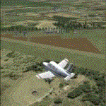
| Endless Runway Concept V2 |
|
Images related to this file:
File Description:

Recently we released "The Endless Runway" for FSX, and it made a huge splash in the community. Well by popular demand we have released a better version with bug fixes, night lighting, HD Textures etc... V1 is still available via our website. The Endless runway is a strange concept and we have made this to give our Flight Sim friends the chance to "TEST" the idea to the fullest.
| Filename: | Endless_Runway_Concept_V2.zip |
| License: | Freeware |
| Added: | 2nd April 2017, 18:00:36 |
| Downloads: | 522 |
| Author: | Mark Piccolo - Soarfly Concepts |
| Size: | 14.43 MB |
| Category: Flight Simulator X - Scenery | |
| Old Rhinebeck Aerodrome |
|
Images related to this file:
File Description:

Old Rhinebeck Aerodrome Scenery FSX/P3D
This scenery package represents Old Rhinebeck Aerodrome, Rhinebeck NY as it existed August - September 2013. It faithfully represents all hangars, outbuildings and objects at the Aerodrome. It includes photo-real textures, an AI New Standard biplane in the pattern, vintage aircraft flight line, seasonal and night textures and a detailed manual of the settings an options that will provide the best performance.
| Filename: | Old_Rhinebeck_Aerodrome.zip |
| License: | Freeware |
| Added: | 3rd November 2013, 19:47:24 |
| Downloads: | 1,213 |
| Author: | Ed Wells, Golden Age Simulations |
| Size: | 370.76 MB |
| Category: Flight Simulator X - Scenery | |
| KGSP - Greenville-Spartanburg International Airport - South Carolina, USA |
|
Images related to this file:
File Description:
Greenville-Spartanburg South Carolina International Airport for FSX. Several improvements have been made to the default airport, including replacing the default terminal with new buildings modelled in FSDS, correctly numbering and coding gates using Airport Design Editor 1.67.5684, creating a new vehicle network, adding ample GA parking, changing the tower view to the roof of the control tower, including the FedEx cargo area with static FedEx trucks, trailers, and warehouse. Also included are Jim Dhaenen's excellent ramp lights and a set of GA flight plans made using AI flight Planner using all FSX default aircraft to liven up the GA area, and the option to include moving road traffic on the approach to Runway 4. Please read the README FIRST.txt and installation.txt files to insure proper installation of all files.
| Filename: | KGSP__GreenvilleSpartanburg_International_Airport_.zip |
| License: | Freeware, limited distribution |
| Added: | 10th June 2016, 21:15:42 |
| Downloads: | 1,661 |
| Author: | Patrick Finch |
| Size: | 3.23 MB |
| Category: Flight Simulator X - Scenery | |
| Colon Aerodrome Traffic - Buenos Aires, Argentina |
|
Images related to this file:
File Description:
Enhancement to Colon Aerodrome SAQO, in Buenos Aires, Argentina. The airport has been modified to accommodate several AI aircraft. A traffic file is included using TEN Default aircraft (so that everybody can see the AI planes). However, these aircraft can be substituted with your own selection, if you know how to modify traffic files. Two flight files are provided to enable you to witness the AI planes taking-off either from Runway 17, or if you prefer, from Runway 35. One AI aircraft is parked in each of the two open hangars.
| Filename: | Colon_Aerodrome_Traffic___Buenos_Aires_Argentina.zip |
| License: | Freeware |
| Added: | 14th July 2016, 09:36:50 |
| Downloads: | 199 |
| Author: | Ronald Falzon |
| Size: | 3.13 MB |
| Category: Flight Simulator X - Scenery | |
| Avalon Airport |
|
File Description:
Avalon airport is an airport in Victoria Australia it is only about a 15 minute flight from Melbourne International airport it is one of the hubs for Low cost airline Jetstar. In FSX its scenery is very sparse considering it is the location of the Australian international Air show. I have created this scenery with Abacus Scenery editor and it adds an environment which represents an Air Show it also adds a terminal (not exact to the real one) and a few other enhancements to the Airport environment.
Note, uses default AFCAD
| Filename: | Avalon_Airport.zip |
| License: | Freeware, limited distribution |
| Added: | 27th February 2007, 02:43:58 |
| Downloads: | 2,046 |
| Author: | Scott Hickey |
| Size: | 444.98 KB |
| Category: Flight Simulator X - Scenery | |
| TNCA |
|
File Description:
Queen Beatrix International Airport (IATA: AUA, ICAO: TNCA) (Papiamento: Aeropuerto Internacional Reina Beatrix), in Oranjestad, Aruba, is an aviation facility. It has flight services to the United States, most countries in the Caribbean, the northern coastal countries of South America, Canada and some parts of Europe, notably the Netherlands. It was named after Queen Beatrix of the Netherlands, the head of state of Aruba.
This file has the right coordenates, with the apron and characteristics of the airport, working jetways. The runways and runways were resized the gates placed on correct location.
| Filename: | TNCA.zip |
| License: | Freeware |
| Added: | 14th April 2011, 02:14:09 |
| Downloads: | 1,901 |
| Author: | Anwar Gonzalez |
| Size: | 29.64 KB |
| Category: Flight Simulator X - Scenery | |
| KFRG Republic Farmingdale Airport |
|
Images related to this file:
File Description:
Located in the heart of Long Island's vibrant Nassau/Suffolk bi-county area, about 30 miles east of New York City. Republic Airport is mainly for general aviation, designated as a reliever airport. There are two main Charter companies, Atlantic aviation and SheltAir aviation, along with 10 flight schools. Republic airport includes, phototexture, with accurately depicted taxiways and aprons, including the buildings and hangars. Snow texture have been added during the winter months. Autogen placed in specific areas and numerous static aircraft on airfield, overall, filled with details. Happy landings!
| Filename: | KFRG_Republic_Farmingdale_Airport.zip |
| License: | Freeware |
| Added: | 18th March 2011, 05:35:04 |
| Downloads: | 1,167 |
| Author: | Eric McCloud |
| Size: | 28.96 MB |
© 2001-2026 AVSIM Online
All Rights Reserved
Privacy Policy |