
Where Flight Simulation Enthusiasts Gather from Around the World!
AVSIM Library - Search Results

| Category: Flight Simulator X - Scenery | |
| Ireland VFR Small Airports part 1 |

|
File Description:
Ireland VFR Small Airports Part 1.
This scenery includes 5 small airports in Ireland. EIDL Donegal is in the far North West, EIAB Abbeyshrule is located in the centre of Ireland. EIKL Kilkenny is located in the South East and Newcastle can be found on the East coast. EITM is a small grass strip to the north West of Dublin. Donegal and Abbeyshrule have paved runways whilst the others consist of small grass strips.
The scenery includes animals, vegetation and rural objects. It also includes sound effects, animations, some high definition people, and aircraft painted using real Irish aircraft photos. Many of the airports include open hangers and buildings modelled from real photographs. Although Donegal is the only one with ILS, full night textures are included for all the airports.
Many of the files are stand alone and can be switched on or off according to user preference. The scenery can be used as a standalone, however it also uses objects from my other scenery addons.
The scenery has been tested with FSXA only and is designed to complement vfr photographic scenery. It will also work with the FSX default terrain, however all objects have been placed using ordinance survey data and may therefore appear misplaced in the default.
Full installation instructions are included in the Readme file.
I hope you enjoy using the airports as much as I enjoyed making them.
| Filename: | Ireland_VFR_Small_Airports_part_1.zip |
| License: | Freeware |
| Added: | 21st December 2011, 00:18:25 |
| Downloads: | 4,975 |
| Author: | George Keogh |
| Size: | 51.33 MB |
| Category: Flight Simulator X - Scenery | |
| Taormina, Italy |
|
File Description:
Scenery Taormina Italy for FS9 and FSX. Installation very simple - file.bgl you need to put in your Addon Scenery scenery subfolder and restart the simulator. The scenario is loaded automatically. This scenario was built with EZ scenery and also reproduces the effects of the nocturnal city.
| Filename: | Taormina_Italy.zip |
| License: | Freeware |
| Added: | 1st June 2011, 18:49:23 |
| Downloads: | 1,887 |
| Author: | Pasquale Marrulli |
| Size: | 1.26 KB |
| Category: Flight Simulator X - Scenery | |
| AW05 - Elandshoogte Airfield - Mpumalanga, South Africa |
|
Images related to this file:
File Description:
Gmax representation of Elandshoogte Airfield, near the Sappi factory outside Ngodwana, Mpumalanga, South Africa with photoreal textures. Elandshoogte airfield is a small airfield with 2 grass runways both measuring under 700m each. The airfield is situated between the trees of the lush Sappi forests on top of a hill and is used by the "fire-bombers" to fight forest fires.
Visit the Aeroworx Blog for the latest SA Vector file downloads http://aeroworxsa.blogspot.com/
| Filename: | AW05__Elandshoogte_Airfield__Mpumalanga_South_Afri.zip |
| License: | Freeware |
| Added: | 29th August 2014, 16:18:48 |
| Downloads: | 1,045 |
| Author: | Kobus van Wyk, Aeroworx |
| Size: | 8.77 MB |
| Category: Flight Simulator X - Scenery | |
| UK Airfields Volume 23 |
|
Images related to this file:
File Description:
Volume 23 consists firstly of a small grass strip Audley End X3AE, 1nm Southwest of Saffron Walden. Second is Beccles EGSM, 4nm Eastsoutheast of Stowmarket and 5nm North of Ipswich. This was once a helicopter terminal for the North Sea Gas Fields and was made at the request of Gerry Francis who used to fly from there. Finally I offer Gamston EGNE, the bustling regional airport of Retford which is 2nm to the North.
| Filename: | UK_Airfields_Volume_23.zip |
| License: | Freeware |
| Added: | 25th June 2011, 22:59:05 |
| Downloads: | 1,273 |
| Author: | Alf Denham |
| Size: | 17.69 MB |
| Category: Flight Simulator X - Scenery | |
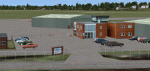
| Manchester Boston Regional Airport (KMHT) |
|
Images related to this file:
File Description:
This airport was made using Airport Design Editor 9x (ADE9x). Manchester Boston Regional Airport is an airport located in Mancherster New Hamshire. I replaced all of the stock building with more accurate ones. I added more gates at the terminal a cargo gates to the southwest. At the cargo area, I added cargo buildings and cargo trucks. At the main terminal I put jetways and more gates. At the general aviation area, I put static aircraft and more parking. I made all this based on Google earth and Bing maps. Please read the readme for instructions on how to install. This is for Flight Simulator X only.
| Filename: | Manchester_Boston_Regional_Airport_KMHT.zip |
| License: | Freeware |
| Added: | 25th December 2011, 10:25:56 |
| Downloads: | 1,732 |
| Author: | Tyler Lawrence |
| Size: | 13.18 MB |
| Category: Flight Simulator X - Scenery | |
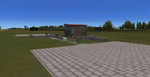
| CAJ4 - Anahim Lake |
|
File Description:
CAJ4 - Anahim Lake - Fictitious secenery
This is a scenery for the CAJ4 Anahim Lake Airport in British Columbia.
It is purely fictitious, I've never benn to Anahim Lake and have no clue on what its look like, it's just to add life (including birds !!!) to the Airport.
| Filename: | CAJ4__Anahim_Lake.zip |
| License: | Freeware |
| Added: | 21st September 2008, 14:31:54 |
| Downloads: | 365 |
| Author: | Arnaud de Saint Hilaire |
| Size: | 7.41 KB |
| Category: Flight Simulator X - Scenery | |
| CYXX - Abbotsford Intl. |
|
File Description:
Welcome to Abbotsford!
Situated in the breathtaking Fraser Valley region of British Columbia, Abbotsford Intl airport is the perfect gateaway.
Large enough to accomodate all type of aircrafts and up to 737's!
The airport has been enhanced to provide service to Cargo, Military base, Heli base with its Heli school, and of course, Single & twin prop.
There is also an option for gliders with the grass rwy located for an inbound Rwy 19C - Multiple buildings and other admins one have been replaced to their original state. CYXX has only one ILS rwy 07. Watch out for wild life! ;)
Hope you'll enjoy your time in Abbotsford Intl Airport!
| Filename: | CYXX__Abbotsford_Intl.zip |
| License: | Freeware |
| Added: | 8th April 2009, 07:25:58 |
| Downloads: | 2,274 |
| Author: | Daniel Louvet |
| Size: | 1.12 MB |
| Category: Flight Simulator X - Scenery | |
| Hope Airfield - CYHE (FSX) |
|
File Description:
Nestled in deep wilderness at the base of the Cascade Mountains, Hope sits on a wide sweeping curve of the Fraser River. Fly north of Hope and follow the Fraser River through the Fraser Canyon. Fly west through the pass to Harrison Hot Springs. This scenery was compiled from satellite images and photographs of the area. Acreages north of the field have been re-done. The lumber operation to the northeast is all new. All scenery objects are sourced from FSX Deluxe. Incidentally, Hope is the longest grass airstrip in Canada. You have a lot of room for a soft landing. VANCOUVER PLUS is required for this scenery to work.
| Filename: | Hope_Airfield__CYHE_FSX.zip |
| License: | Freeware, limited distribution |
| Added: | 16th April 2009, 05:05:06 |
| Downloads: | 688 |
| Author: | Will Jones |
| Size: | 560.21 KB |
| Category: Flight Simulator X - Scenery | |
| Alderney Airport (EGJA) |
|
File Description:
Alderney Airport (EGJA) is located on the island of Alderney in the Channel Islands. I have travelled in and out of the island on many occasions and, despite the lack general lack of information on the internet about the airport, this is a pretty accurate representation. Features include accurate control tower, accurate terminal building, grass parking area, static aircraft, ground vehicles, car park, fire-station, surrounding trees, perimeter fencing and more. Many night textures and custom AFCAD file included. The airport is at N49 42 44 and W002 12 88. This scenery is for FSX but should also work under FS2004. It may even work in earlier versions of FS but this is untested.
| Filename: | Alderney_Airport_EGJA.zip |
| License: | Freeware, limited distribution |
| Added: | 29th October 2006, 03:17:06 |
| Downloads: | 8,383 |
| Author: | Tim Clayton |
| Size: | 2.29 MB |
| Category: Flight Simulator X - Scenery | |
| YPLU Plutonic Gold Mine, Peak Hill, Western Australia |
|
File Description:
The Plutonic Gold Mine is located 82 km east north east of Peak Hill, Western Australia. It is operated by Barrick Gold and located at the Plutonic Well Greenstone Belt. In 1988, Great Central Mines discovered the deposit which was to become Plutonic, which the company sold for A$50 million. The site was then owned by Plutonic Resources, a major Australian gold mining and exploration company. Homestake Mining Company purchased Plutonic in April 1998 for more than $1.0 billion, and, in turn, Homestake was acquired by Barrick Gold at the end of 2001. REQUIRES Blencowe_LibraryKit.zip
REQUIRES blencowe_librarykit_309494.zip (Available HERE)
| Filename: | YPLU_Plutonic_Gold_Mine_Peak_Hill_Western_Australi.zip |
| License: | Freeware |
| Added: | 28th February 2013, 14:00:30 |
| Downloads: | 247 |
| Author: | Alan Blencowe |
| Size: | 10.2 MB |
© 2001-2026 AVSIM Online
All Rights Reserved
Privacy Policy |