
Where Flight Simulation Enthusiasts Gather from Around the World!
AVSIM Library - Search Results

| Category: Flight Simulator X - Scenery | |
| RJTT - Tokyo Haneda Intl - Tokyo, Japan |

|
Images related to this file:
File Description:
This scenery is a very accurate rendition of Haneda Intl airport and made only for FSX: one file with the Crosswind runways operating, where all 4 runways will be used for takeoff/landing and one file as the default runway operation: the new International terminal expansion added, Terminal 2 and gates also updated, assigned parking with extra parking including several gates for the A380, all taxiways and taxi signs updated to the latest charts, extra fuel trucks, support vehicle roads rebuilt, lighted helipad with a start location, airport views are from inside the control tower (when in tower view) please view the readme before installation
| Filename: | RJTT__Tokyo_Haneda_Intl__Tokyo_Japan.zip |
| License: | Freeware, limited distribution |
| Added: | 23rd January 2015, 17:41:03 |
| Downloads: | 44,586 |
| Author: | Ray Smith |
| Size: | 2.71 MB |
| Category: Flight Simulator X - Scenery | |
| KFKN - Franklin Municipal / John Beverly Rose Airport - Virginia, USA |
|
File Description:
Also known as Franklin Municipal Airport or John Beverly Rose Field (IATA: FKN, ICAO: KFKN, FAA LID: FKN) is a public airport in Isle of Wight County, Virginia, United States. The airport is owned by the City of Franklin and is located at 32470 John Beverly Rose Drive, two nautical miles (4 km) northeast of the city's central business district.
Added aircraft parkng and custom buildings. Created with Airport Design Editor by ScruffyDuck Software using current FAA documentation and Google Earth measurements, this package offers a replacement for FSX's stock airport. All these enhancements are as close to the real airport as I can get with stock library objects and custom buildings.
| Filename: | KFKN__Franklin_Municipal__John_Beverly_Rose_Airpor.zip |
| License: | Freeware |
| Added: | 10th November 2014, 01:11:40 |
| Downloads: | 302 |
| Author: | Wayne Roberts |
| Size: | 344.67 KB |
| Category: Flight Simulator X - Scenery | |
| YCVM Caversham RAAF Base, Western Australia (Closed 1942) |
|
File Description:
YCVM Caversham (Closed 1942) - the last remains of this site as it looked in 2010. If you had permission to land, runway 05 - 23 would still be accessible for a light aircraft and an ultralight could still land on what is left of the others. Sadly, this historic site is destined to become a housing estate so this is my attempt to preserve it. As with most military sites, there is a shortage of images so I would appreciate any help to make it more accurate for the period rather than what currently remains. REQUIRES Blencowe_LibraryKit.zip
REQUIRES blencowe_librarykit_309494.zip (Available HERE)
| Filename: | YCVM_Caversham_RAAF_Base_Western_Australia_Closed_.zip |
| License: | Freeware |
| Added: | 25th February 2013, 09:26:49 |
| Downloads: | 282 |
| Author: | Alan Blencowe |
| Size: | 9.52 MB |
| Category: Flight Simulator X - Scenery | |
| Thanlwin Bridge Mawlamyine VYMM (Moulmein-Martaban) V2.0 |
|
File Description:
The Thanlwin Bridge of Mawlamyine, linking Mawlamyine, the capital of Mon State, and Mottama side, is the longest and largest of its kind in Myanmar (Burma). It is 11575 feet long and has a 28-foot-wide two-lane motorway with the length of two miles, a 14-foot-wide railroad with the length of four miles, and two six-foot-wide walkways on it. The opening ceremony was on February 5, 2005 (Saturday) at 8 am on Mawlamyine bank. This scenery was produced based on pictures of satellites. Many Thanks go to the teams of FSX Planner, SceneGenX, Open Ports Scanner, AFXBgDownloader, FSUIPC and Google Earth. This scenery is only for FSX, for FS2004 please download bridgevymmfs9.zip
| Filename: | Thanlwin_Bridge_Mawlamyine_VYMM_MoulmeinMartaban_V.zip |
| License: | Freeware, limited distribution |
| Added: | 8th January 2008, 23:44:34 |
| Downloads: | 533 |
| Author: | HOUSE-RP, Robby Pauletto |
| Size: | 16.72 KB |
| Category: Flight Simulator X - Scenery | |
| Northeast New Jersey 5 Meter Mesh Terrain |
|
Images related to this file:
File Description:
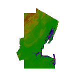
High Resolution Northeast New Jersey 5 Meter Mesh Terrain by Wally-Bob represents a significant improvement over FSX default 38 meter mesh terrain. The results are also dramatic compared to 10 meter compressed payware mesh as lossless compression compilation (read no data loss) is used. Lossless compiling produces renderings that have the Crispness of the Real World Terrain. Fly the Hudson River and view the Palisades as they are in real life, see the screen shots enclosed. High Quality 5 meter mesh terrain is a must have for mountainous areas especially where photo scenery is also used to render the virtual world. Manual includes FSX configuration and scenery installation tips. USGS LiDAR 1/9 Arc-Second source data.
| Filename: | Northeast_New_Jersey_5_Meter_Mesh_Terrain.zip |
| License: | Freeware, limited distribution |
| Added: | 26th February 2011, 21:35:52 |
| Downloads: | 1,100 |
| Author: | Walter Roberts |
| Size: | 135.89 MB |
| Category: Flight Simulator X - Scenery | |
| JY43 Hill Top Airport NJ |
|
Images related to this file:
File Description:
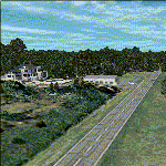
I was flying around the FSX world looking for a real world sloping airstrip just begging to be modeled with a touchdown tire squealing, smoking rubber - that kind of hardened surface sloping runway after I finally figured out how to persuade the FSX SDK to compile one. The Airfield Candidate shall have high density LiDAR elevation and high resolution Orthoimagery data available for public download. I was flying a Beechcraft Baron 58 over Wanaque Reservoir in Northeast NJ of all places when I happened upon a photo scenery runway on a sloping hill top without the usual FSX flattened airport plateau effect and FSX textured runway. They have missed this one ! Hello JY43. - Wally-Bob
| Filename: | JY43_Hill_Top_Airport_NJ.zip |
| License: | Freeware, limited distribution |
| Added: | 9th March 2011, 23:20:14 |
| Downloads: | 1,073 |
| Author: | Walter Roberts |
| Size: | 67.74 MB |
| Category: Flight Simulator X - Scenery | |
| Frankfurt Main Airport with new 25R ILS approach (v2.0) |
|
Images related to this file:
File Description:
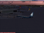
This scenery is an update to v1.0 of the FSX Frankfurt/Main airport package and was designed using ADE v1.40.
This update now features additional jetways, vehicle roadways around Terminal 2, up-to-date airline mapping to gates and additional taxiway and CAT II/III signs. ** Gates have been resized and added as per current layout ** Additional fuel trucks & support vehicle roads built around the airport ** 3 helipad start locations added ** B Gates now contain double jetways ** The control tower view has been moved to the south side and aprons have been remodelled ** In addition the ILS for Rwy25R has been updated to reflect the new frequency change from 109.50 to 111.55Mhz as of June 2009.
| Filename: | Frankfurt_Main_Airport_with_new_25R_ILS_approach_v.zip |
| License: | Freeware |
| Added: | 4th November 2009, 19:49:58 |
| Downloads: | 1,370 |
| Author: | Mark Aldridge |
| Size: | 3.06 MB |
| Category: Flight Simulator X - Scenery | |
| Land's End SeaPlanes; West Coast Travels |
|
File Description:
Part III in the four part scenery series of Land's End SeaPlanes. Part III, West Coast Travel covers the United States West Coast from Seattle Washington to San Diago, California. This scenery pack requaires Lands End SeaPlanes Part I and Part II. Part III includes, KAST - Astoria Regional Airport, KONP - Newport Municipal Airport, Newport, Oregon; KOTH - North Bend Airport, North Bend Oregon; KBOK - Brookings State Airport, Brookings Oregon; KACV - Arcata-Eureka Airport, Arcata, California; OQ5 - Shelter Cove Airport, Shelter Cove, Ca; CA51 - The Sea Ranch, Ca; KHAF - Half Moon Bay, Ca; O62 - Carmel Valley Vintage; L52 - Oceano County; and more. Package includes hundreds of custom models, effects, textures. Includes both day and night textures.
| Filename: | Lands_End_SeaPlanes_West_Coast_Travels.zip |
| License: | Freeware, limited distribution |
| Added: | 21st November 2008, 19:06:05 |
| Downloads: | 2,617 |
| Author: | Chris Carel |
| Size: | 42.47 MB |
| Category: Flight Simulator X - Scenery | |
| 17Z - Manakotak Airport - Alaska |
|
Images related to this file:
File Description:
Manokotak Airport (IATA: KMO, ICAO: PAMB, FAA LID: MBA, formerly 17Z) is a state-owned public-use airport located one mile (2 km) north of the central business district of Manokotak, a city in the Dillingham Census Area of the U.S. state of Alaska.
Increased runway 3/21 from 3,300 feet to 4,000 feet. Added aditional aprons and custom buildings. Changes are based on 2006 construction plans.
Created with Airport Design Editor 9x by ScruffyDuck Software using current FAA documentation and Google Earth measurements, this package offers a replacement for FSX's stock airport. All these enhancements are as close to the real airport as I can get with stock library objects and custom buildings.
| Filename: | 17Z__Manakotak_Airport__Alaska.zip |
| License: | Freeware |
| Added: | 16th January 2015, 20:14:02 |
| Downloads: | 789 |
| Author: | Wayne Roberts |
| Size: | 53.55 KB |
| Category: Flight Simulator X - Scenery | |
| Helena Regional Airport (KHLN) |
|
Images related to this file:
File Description:
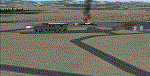
Welcome to Helena Regional Airport for FSX! All the structures are custom. Airport vehicles use
the proper vehicle paths and do not use taxiways. The Rocky Mountain Emergency Services fire training
facility is depicted and there is a training session in progress. Be sure to visit Mustard Mickey's
before your travels take you through the scenic Montana wilderness. Stop by Vetter Aviation and thank
Brent for his over two decades of service to the aviation industry.
As with all my work the structures are original work. Some are accurate, some are workups based on what
I think they might look like.
Three scenery complexity levels are used (normal,dense, and very dense). More eye candy appears with each
increase.
| Filename: | Helena_Regional_Airport_KHLN.zip |
| License: | Freeware, limited distribution |
| Added: | 6th December 2019, 17:13:13 |
| Downloads: | 402 |
| Author: | Brett Delana |
| Size: | 6.29 MB |
© 2001-2026 AVSIM Online
All Rights Reserved
Privacy Policy |