
Where Flight Simulation Enthusiasts Gather from Around the World!
AVSIM Library - Search Results

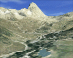
| Category: Flight Simulator X - Scenery | |
| Cosenza, Calabria, Italy, Photo Real |

|
File Description:
The scenery covers the area of Cosenza and Sila (Calabria, South Italy). The Photo Real Scenery is wide for around 3500 squared Kms. The airport of Lamezia Terme (ICAO code LICA) are found near to the scenery (see map). Otherwise the airport of Crotone (ICAO code LIBC) can be used.
Note for FS2004 user:
This scenery is compatible to 100% with the FS2004 but for the best results, use it in association with Pietro Mauri Italymesh2004.
| Filename: | Cosenza_Calabria_Italy_Photo_Real.zip |
| License: | Freeware |
| Added: | 19th December 2006, 03:16:03 |
| Downloads: | 11,613 |
| Author: | Fulvio Mazzokan |
| Size: | 97.02 MB |
| Category: Flight Simulator X - Scenery | |
| W29 - Bay Bridge Airport - Stevensville, Maryland - USA |
|
Images related to this file:
File Description:
FSX Scenery - Bay Bridge Airport (FAA LID: W29) is a county-owned public-use airport located in Stevensville, Maryland.The airport is named for the nearby Chesapeake Bay Bridge and is mostly used for general aviation. Bay Bridge Airport covers an area of 72 acres (29 ha) and contains one asphalt runway (11/29) measuring 2,903 x 60 ft (885 x 18 m). Non-default AI repaints/traffic available by John Burford. Scenery created by John B. Loney, Jr.
| Filename: | W29__Bay_Bridge_Airport__Stevensville_Maryland__US.zip |
| License: | Freeware, limited distribution |
| Added: | 18th November 2014, 14:54:33 |
| Downloads: | 473 |
| Author: | John B. Loney, Jr. |
| Size: | 8.2 MB |
| Category: Flight Simulator X - Scenery | |
| Valle D'Aosta part 1 (Est), Alps, Italy, Photo Real |
|
Images related to this file:
File Description:
Re-upload. The scenery covers the oriental part of the Valle D'Aosta, North Italy, Alps. The Photo Real Scenery is wide for around 2200 squared Kms. The airport of Aosta (ICAO code LIMW) is found near to the scenery (see map). The complete scenery of the valley was divided in 2 parts to fit the 100Mb file space limit: part 1 (this file) and part 2 (West side see AVSIM library - valle_aosta_west_vfr.zip). For FSX and FS9.
| Filename: | Valle_DAosta_part_1_Est_Alps_Italy_Photo_Real.zip |
| License: | Freeware |
| Added: | 10th June 2010, 23:10:30 |
| Downloads: | 16,643 |
| Author: | Fulvio Mazzokan |
| Size: | 62.3 MB |
| Category: Flight Simulator X - Scenery | |
| Liverpool Xtreme |
|
Images related to this file:
File Description:

Liverpool John Lennon Airport (UK) is a busy Low fares airline hub for Easyjet and Ryanair, it also has a large GA area. This scenery captures the airport in all its glory.Includes detailed images of the real Liverpool airport, it has a high resolution 25cm base image, animation, effects, nearly all the buidlings, extremely detailed ground markings, interactive service fleet and stunning night effects.
DEMO VERSION ONLY, funtional but has 'demo signs' Full price is GBP14.99
| Filename: | Liverpool_Xtreme.zip |
| License: | Commercial demo |
| Added: | 7th May 2011, 04:03:25 |
| Downloads: | 1,136 |
| Author: | Gary Summons |
| Size: | 76.38 MB |
| Category: Flight Simulator X - Scenery | |
| Jacksonville, FL - Jacksonville International Airport (KJAX) |
|
Images related to this file:
File Description:
After a long wait for imagery to become available on the internet for the new terminal at KJAX, this airport scenery has been completed. Major airline gate assignments are real. Generic floating buildings have been replaced with custom and library objects. Landclass changes, roads, rework of runways, taxiways and aprons, placement of library objects and a library of new airport buildings are included. Scenery in this package is based on Virtual Earth (Bing) and Google Earth imagery.
| Filename: | Jacksonville_FL__Jacksonville_International_Airport_KJAX.zip |
| License: | Freeware |
| Added: | 24th September 2011, 02:01:06 |
| Downloads: | 5,737 |
| Author: | Art Poole |
| Size: | 2.42 MB |
| Category: Flight Simulator X - Scenery | |
| Akwa Ibom Airport-DNAI FSXP3D |
|
Images related to this file:
File Description:
Akwa Ibom Airport (IATA: QUO, ICAO: DNAI), is an airport serving Uyo, the capital of Akwa Ibom State in Nigeria. The airport is 24 kilometres (15 mi) southeast of Uyo, and 16 kilometres (9.9 mi) northwest of the river port of Oron.
The Akwa Ibom non-directional beacon (Ident: AI) and Uyo VOR-DME (Ident: AKW) are located on the field.
Photoreal Background, Corrected Parkings, Added more buildings, Ramp Lights(Dyanmic Lights only for P3D v4), Airport charts.
| Filename: | Akwa_Ibom_AirportDNAI_FSXP3D.zip |
| License: | Freeware |
| Added: | 13th December 2019, 19:01:39 |
| Downloads: | 394 |
| Author: | Raheem Adeleke |
| Size: | 62.37 MB |
| Category: Flight Simulator X - Scenery | |
| CYHZ - Halifax International Airport - NS, Canada - UPDATE |
|
File Description:
UPDATE: CYHZ - Halifax Internationl Airport, Nova Scotia, Canada.
Note: This version can be installed in both FSX and Lockheed Martin P3D v1.4
This is an update to my previous scenery upload, 10-31-2009, to reflect changes to runway 05/23. This runway as been extended from 8800 feet to 10500 feet to accommodate the 'heavies' now using this airport. Taxiway designators update and/or added. Minor adjustment made runway approach headings. Main body of the airport remains unchanged.
| Filename: | CYHZ__Halifax_International_Airport___NS_Canada__U.zip |
| License: | Freeware |
| Added: | 26th November 2013, 02:24:35 |
| Downloads: | 26,540 |
| Author: | Robert Catherall |
| Size: | 2.74 MB |
| Category: Flight Simulator X - Scenery | |
| Sarasota-Bradenton (KSRQ) - Fix |
|
File Description:
An ADE software update occurred during the development of scenery for Sarasota/Bradenton, and it has now become apparent that runway approach altitudes were lost when the old ADE file was opened with the new version. This will cause ATC to direct aircraft to make their approaches at altitude 0, and AI will taxi to the runways from miles away. If you have this scenery (sarasota-bradenton_fl.zip in the AVSIM library), substitute this .bgl file to correct the problem.
| Filename: | SarasotaBradenton_KSRQ__Fix.zip |
| License: | Freeware |
| Added: | 23rd January 2010, 11:14:01 |
| Downloads: | 1,233 |
| Author: | Art Poole |
| Size: | 24.76 KB |
| Category: Flight Simulator X - Scenery | |
| Sicily VFR - Terrain Mesh SRTM 1 Arc/Sec version 3 |
|
Images related to this file:
File Description:
Enhanced Terrain Mesh with SRTM 1 Arc/Sec (30 meters) version 3 at LOD 11 (19mt meters/pixel). SRTM 1 Arc-Second Global elevation data offer worldwide coverage of void filled data at a resolution of 1 arc-second (30 meters/0,000278 degrees) and provide open distribution of this high-resolution global data set. The SRTM 1 Arc-Second Global (30 meters) data set released in phases starting September 24, 2014. Fully compatible also with P3D.
| Filename: | Sicily_VFR__Terrain_Mesh_SRTM_1_ArcSec_version_3.zip |
| License: | Freeware |
| Added: | 7th February 2015, 20:18:17 |
| Downloads: | 4,688 |
| Author: | Giovanni Miduri |
| Size: | 43.32 MB |
| Category: Flight Simulator X - Scenery | |
| Opa Locka, FL Airport (KOPF) |
|
Images related to this file:
File Description:
This scenery includes the old control tower (inactave), a temporary control tower (active) and a new control tower (inactive, near completion). Generic floating buildings have been replaced with custom and library objects. Landclass changes, roads, rework of runways, taxiways and aprons, placement of library objects and a library of new airport buildings are included. Military parking is included at the Coast Guard facility. Scenery in this package is based on Virtual Earth (Bing) and Google Earth imagery.
| Filename: | Opa_Locka_FL_Airport_KOPF.zip |
| License: | Freeware |
| Added: | 7th April 2011, 00:15:39 |
| Downloads: | 2,295 |
| Author: | Art Poole |
| Size: | 2.83 MB |
© 2001-2026 AVSIM Online
All Rights Reserved
Privacy Policy |