
Where Flight Simulation Enthusiasts Gather from Around the World!
AVSIM Library - Search Results

| Category: Flight Simulator X - Scenery | |
| OAMS – German Camp Marmal ISAF |

|
File Description:
As of early January 2002 approximately 200 soldiers from the 10th Mountain Division, known as Task Force Commando, were operating from the Mazar-e-Sharif Airfield. The Mazar-e-Sharif Airfield's runway has a length of 3,100 meters/10,500 feet.
Germany took command of the International Security Assistance Force’s Regional Area North at the end of March 2006. The airfield functions as main hub for the exchange of personnel as well as air cargo for the international stabilization and peace support forces in Northern Afghanistan. The German government has German Camp Marmal contributed 53 million euros to reconstruction work at Mazari-Sharif airport. Here is the tribute for the german soldiers in afghanistan.
| Filename: | OAMS__German_Camp_Marmal_ISAF.zip |
| License: | Freeware |
| Added: | 1st October 2007, 21:33:18 |
| Downloads: | 1,577 |
| Author: | Volker Gießübl |
| Size: | 9.6 MB |
| Category: Flight Simulator X - Scenery | |
| LOWK - Klagenfurt, Austria |
|
Images related to this file:
File Description:

Klagenfurt Airport (ICAO: LOWK), also known as Kaernten Airport, is the airport of Klagenfurt, the sixth-largest city in Austria.
It is located near the city center of Klagenfurt and serves some flights to European leisure and metropolitan destinations.
Klagenfurt Airport consists of one small passenger terminal building which features some shops and restaurants as well as a visitors terrace.
The apron provides several stands for mid-sized planes such as the Airbus A320 as well as smaller general aviation aircraft.
As there are no jet bridges, buses are used for boarding.
In this version you have animated worker and by the glock hanger you have a new scenery with a moving limousine and a moving gentlemen.
| Filename: | LOWK__Klagenfurt_Austria.zip |
| License: | Freeware |
| Added: | 27th August 2015, 19:57:36 |
| Downloads: | 287 |
| Author: | Manfred Marbler |
| Size: | 186.36 MB |
| Category: Flight Simulator X - Scenery | |
| Seattle Tacoma Intl (KSEA) Asbuilt Scenery Ver2 |
|
File Description:
This update adds photo-based terrain in and around the airport with seasonal and night variations, and has minor tweaks to the airport design to help AI traffic movement. This is in addition to the Version 1 features that include: Current runway numbering (16R/34L changed to 16C/34C) is included. All runways and taxiways are placed at correct geographic coordinates. Shoulders along the runways and taxiways have been added and surfaces changed to present an appearance that looks a little more realistic than the default airport. Default scenery for terminals and buildings are reused, parking and jetways have been adjusted to match current assignments. A current copy of the FAA Airport Diagram is included for reference.
| Filename: | Seattle_Tacoma_Intl_KSEA_Asbuilt_Scenery__Ver2.zip |
| License: | Freeware, limited distribution |
| Added: | 18th January 2008, 01:23:59 |
| Downloads: | 7,782 |
| Author: | Dan Downs |
| Size: | 5.38 MB |
| Category: Flight Simulator X - Scenery | |
| DAAT - Aguenar / Hadj Bey Akhamok Airport - Tamanrasset, Algeria |
|
File Description:
Aguenar - Hadj Bey Akhamok Airport (French: Aeroport de Tamanrasset / Aguenar - Hadj Bey Akhamok) (IATA: TMR, ICAO: DAAT), also known as Aguenar Airport or Tamanrasset Airport, is an airport serving Tamanrasset, a city in the Tamanrasset Province of southern Algeria. It is located 3.6 nautical miles (6.7 km) northwest of the city. The airport was an alternative landing site for NASA's Space Shuttle, and have been used for American military operations.
In the mid-2000s it was extensively upgraded to serve additionally as a military base, with 10 hardened aircraft shelters, aprons, personnel accommodation and other facilities. Please note that runway 08-26 and ILS are out of service at this time. This work is dedicated to West Wind Airlines.
| Filename: | DAAT__Aguenar__Hadj_Bey_Akhamok_Airport__Tamanrass.zip |
| License: | Freeware |
| Added: | 21st April 2013, 22:09:29 |
| Downloads: | 2,115 |
| Author: | Anwar Gonzalez |
| Size: | 7.17 MB |
| Category: Flight Simulator X - Scenery | |
| St Marys Municipal KOYM |
|
Images related to this file:
File Description:
FSX Scenery - St. Marys Municipal Airport (IATA: STQ, ICAO: KOYM, FAA LID: OYM) is a city-owned public-use airport three miles (5 km) southeast of the central business district of St. Marys, a city in Elk County, Pennsylvania, United States..[1] This general aviation airport is located off South Michael Road in St. Marys. St. Marys Municipal Airport covers an area of 283 acres (115 ha) and contains one runway designated 10/28 with a 4,300 x 75 ft (1,311 x 23 m) asphalt pavement. For the 12-month period ending October 31, 2007, the airport had 6,730 aircraft operations, an average of 18 per day: 85% general aviation, 15% air taxi and
| Filename: | St_Marys_Municipal_KOYM.zip |
| License: | Freeware, limited distribution |
| Added: | 2nd November 2010, 01:35:54 |
| Downloads: | 535 |
| Author: | John B. Loney, Jr. |
| Size: | 1.06 MB |
| Category: Flight Simulator X - Scenery | |
| Greater Kankakee KIKK |
|
Images related to this file:
File Description:
FSX Scenery - Greater Kankakee Airport (IATA: IKK, ICAO: KIKK, FAA LID: IKK) is a public airport located three miles (5 km) south of the central business district of Kankakee, in Kankakee County, Illinois, United States. The airport was opened in 1962 and continues to operate as a general aviation facility serving the Kankakee area and South Chicago. It is 60 miles (97 km) south of Chicago and 75 miles (121 km) north of Champaign, Illinois. It is the largest Airport between the Chicago Midway Airport and the Champaign Airport. Greater Kankakee is a general aviation airport, consisting of mostly private aircraft with a mix of corporate and business aircraft usage. Created by John B Loney Jr.
| Filename: | Greater_Kankakee_KIKK.zip |
| License: | Freeware, limited distribution |
| Added: | 20th March 2012, 01:36:22 |
| Downloads: | 646 |
| Author: | John B. Loney, Jr. |
| Size: | 4.09 MB |
| Category: Flight Simulator X - Scenery | |
| KELM - Elmira Corning Regional Airport - New York |
|
File Description:
This is an airport package including all the most recent buildings at Elmira Corning Regional Airport KELM. Included are the Sikorsky building and recent runway extensions. I added some static aircraft to the now defunct National Warplane Museum, and Schweitzer plant. These are a historical reference to better days in the past for KELM. Now that Sikorsky has closed, there are a lot of disused structures there. I also added the local Mall and a local industrial park that was once home to an RC club, the field was sometimes used as a glider emergency landing field. It no longer exists in the real world.Look for it north east of the airport.
| Filename: | KELM__Elmira_Corning_Regional_Airport__New_York.zip |
| License: | Freeware |
| Added: | 7th June 2014, 05:32:22 |
| Downloads: | 607 |
| Author: | Jon Davidson |
| Size: | 2.35 MB |
| Category: Flight Simulator X - Scenery | |
| KUTS - Huntsville Airport - Texas, USA |
|
Images related to this file:
File Description:
FSX Scenery - Bruce Brothers Huntsville Regional Airport, also known as Huntsville Municipal Airport, (IATA: HTV, ICAO: KUTS, FAA LID: UTS), is a city owned, public use airport located two nautical miles (4 km) northwest of the central business district of Huntsville, a city in Walker County, Texas, United States. It is included in the National Plan of Integrated Airport Systems for 2011-2015, which categorized it as a general aviation facility. Although most U.S. airports use the same three-letter location identifier for the Federal Aviation Administration (FAA) and International Air Transport Association (IATA), this airport is assigned UTS by the FAA and HTV by the IATA. For your flying pleasure by John B. Loney, Jr.
| Filename: | KUTS__Huntsville_Airport__Texas_USA.zip |
| License: | Freeware, limited distribution |
| Added: | 7th September 2015, 22:30:00 |
| Downloads: | 459 |
| Author: | John B. Loney, Jr. |
| Size: | 8.64 MB |
| Category: Flight Simulator X - Scenery | |
| Crete Island, Version 2 |
|
Images related to this file:
File Description:
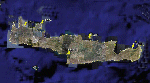
Crete is the bigger than the islands of the Greek archipelago and it is the south rampant of the Aegean sea. This scenery contains the following airports: LGIR, LGSA, LGOB, LGTL and 78 cities.
In this 2nd version I have used the mesh terrain of Yiannis Dermitzakis that offers a bigger realism to the costs. This has put under an obligation to reconstruct the entirety of the populations of the since costs they were located inside the sea. At the same time I have been able to redraw them populations with houses and real facilities that. I believe that I can offer a quite realistic scenery especially in the group of populations of the coast.
| Filename: | Crete_Island_Version_2.zip |
| License: | Freeware |
| Added: | 7th November 2009, 21:08:05 |
| Downloads: | 6,014 |
| Author: | Toni Agramont |
| Size: | 31.14 MB |
| Category: Flight Simulator X - Scenery | |
| KCEF - Westover Air Reserve Base/Metropolitan Airport - Springfield/Chicopee, MA |
|
File Description:
MS didn't do much with military bases in FSX. Here is an improved version of the stock Westover ARB.
I added Military_cargo parking spaces and GA spaces at Metropolitan Airport which occupies a small part
of Westover ARB. I added the fire station and fire trucks. I removed and replaced most default buildings,
added additional buildings and moved the control tower. I added static fuel trucks, parking lots with cars,
static planes, and light poles. I added, removed, or adjusted taxiways and aprons as needed to more closely
resemble the real world base.
Westover is the largest Air Reserve Base in the world and is a backup landing site for the space shuttle.
| Filename: | KCEF__Westover_Air_Reserve_BaseMetropolitan_Airpor.zip |
| License: | Freeware |
| Added: | 8th April 2009, 06:56:48 |
| Downloads: | 1,311 |
| Author: | Jim Cook |
| Size: | 22.6 KB |
© 2001-2026 AVSIM Online
All Rights Reserved
Privacy Policy |