
Where Flight Simulation Enthusiasts Gather from Around the World!
AVSIM Library - Search Results

| Category: Flight Simulator X - Scenery | |
| Egypt Mesh Scenery SRTM |

|
File Description:
This scenery is based on the collected Datas of the NASA Spaceshuttle mission SRTM
The Shuttle Radar Topographic Mission in the year 2000 made by the Spaceshuttle Endevour.
| Filename: | Egypt_Mesh_Scenery_SRTM.zip |
| License: | Freeware, limited distribution |
| Added: | 2nd January 2012, 16:25:24 |
| Downloads: | 10,997 |
| Author: | Mathias Schindler |
| Size: | 129.51 MB |
| Category: Flight Simulator X - Scenery | |
| WADD - Denpasar International Airport - Bali, Indonesia |
|
Images related to this file:
File Description:
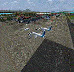
Bali Ngurah Rai International Airport, also known as Denpasar International Airport, is located in southern Bali, 13 km south of Denpasar.
It is Indonesias third-busiest international airport.
| Filename: | WADD__Denpasar_International_Airport__Bali_Indones.zip |
| License: | Freeware |
| Added: | 31st May 2016, 16:17:59 |
| Downloads: | 12,764 |
| Author: | morten thomas van der linden |
| Size: | 60.67 MB |
| Category: Flight Simulator X - Scenery | |
| Tandragee airfield patch for UK2000 users |
|
Images related to this file:
File Description:

Patch for Tandragee/Kernan airfield for UK2000 scenery users. The code EGTA I have used for the strip although not in FSX actually exists and is depicted in the UK2000 airports scenery. If you have these airports installed apply this patch and you will be able to find Tandragee unfer the name "Kernan", city "Tandragee" and code "EG1". If you do not have UK2000 installed you do not need to apply this patch.
| Filename: | Tandragee_airfield_patch_for_UK2000_users.zip |
| License: | Freeware |
| Added: | 9th October 2014, 14:12:38 |
| Downloads: | 303 |
| Author: | Vassilios Dimoulas |
| Size: | 2.46 KB |
| Category: Flight Simulator X - Scenery | |
| Siberia - N. Europe 90 metre mesh - Part 3, Batch 2 |
|
File Description:
Siberia, and Northern Europe 90m mesh for FSX only. Part 3 - Batch 2. There are six zips in this batch to download.
This coverage constitutes an area above 60 degrees latitude. (Northern area the NASA SRTM radar didn't give any scans for).
This is 90m mesh, which Jonathan de Ferranti of: http://www.viewfinderpanoramas.org/ who has originally made as Raw DEM, and he has kindly allowed me to turn it into BGL's for use in
| Filename: | Siberia__N_Europe_90_metre_mesh__Part_3_Batch_2.zip |
| License: | Freeware |
| Added: | 15th March 2009, 12:48:58 |
| Downloads: | 620 |
| Author: | Wayne Evans |
| Size: | 79.75 MB |
| Category: Flight Simulator X - Scenery | |
| Grafton District Airport (YGFN) |
|
File Description:
A delighful small airport approximately 80 nautical miles from Coffs Harbour and a slightly shorter distance to Ballina and Lismore. This makes a good stopover for hopping down the east coast of Australia.
The size of the airport has allowed me to put in that extra detail which makes to terminal and surrounds very much "as in real life". Photographic textures are used for the background blended into the Winter and Spring seasons.
| Filename: | Grafton_District_Airport_YGFN.zip |
| License: | Freeware |
| Added: | 5th November 2007, 11:50:00 |
| Downloads: | 1,765 |
| Author: | John Ross |
| Size: | 1.17 MB |
| Category: Flight Simulator X - Scenery | |
| Rotorua: Government Gardens Scenery |
|
File Description:
This FSX scenery contains custom models of the main heritage buildings in the Goverment Gardens in the Tourist city of Rotorua, New Zealand.
This scenery release includes:
Custom Models of:
The Bath House (A.k.a The Rotorua Museum)
The Blue Baths
The ‘Tea Rooms’
The Gardeners Quarters
A Lawn Bowls/Croquet Building
The Rotorua District Council Chambers
The Rotorua Convention Centre
High Resolution Aerial Photograpy covering the Gardens (Summer, Daylight only)
Default trees
Autogen
| Filename: | Rotorua_Government_Gardens_Scenery.zip |
| License: | Freeware, limited distribution |
| Added: | 26th November 2007, 04:30:34 |
| Downloads: | 3,169 |
| Author: | Tim Barnes |
| Size: | 6.17 MB |
| Category: Flight Simulator X - Scenery | |
| RAF Wellingore - Lincolnshire, England |
|
File Description:
This is my interpretation of the fighter station RAF Wellingore, in Lincolnshire. I have used a little poetic licence in placing the 8 L type blister hangers and the small technical area to the north west of the airfield, I hope you enjoy my effort. You will need to download (if you haven't already do so) scenery libraries by Ian Pearson and Ted Andrews which can be obtain from Ins website at www.ianpsdarkcorner.co.uk.
| Filename: | RAF_Wellingore__Lincolnshire_England.zip |
| License: | Freeware |
| Added: | 26th September 2015, 13:28:45 |
| Downloads: | 241 |
| Author: | Terry Boissel |
| Size: | 6.02 KB |
| Category: Flight Simulator X - Scenery | |
| Mansfield, Ma (1b9) |
|
File Description:
mansfield Ma (1b9) is a uncontrolled field in eastern massachusetts. i added more GA parking, static aircraft on the ramp to show how it looks in reality, added missing ramp space, missing hangers, misssing taxiways, re-positioned the turf strip to its proper location, added a fuel truck, added hangers and a house that mirrors the real thing, and added extra's to make it look as real as possible using default FSX library objects.
| Filename: | Mansfield_Ma_1b9.zip |
| License: | Freeware |
| Added: | 9th December 2008, 23:44:31 |
| Downloads: | 480 |
| Author: | kyle cormier |
| Size: | 5.13 KB |
| Category: Flight Simulator X - Scenery | |
| Bristol Clifton Suspension Bridge and Observatory |
|
Images related to this file:
File Description:
Orbx Compatible Bristol Clifton Suspension Bridge and Observatory - This scenery adds the Clifton Suspension Bridge & Observatory to Orbx EU England Regional scenery package near the city of Bristol, England. The Clifton Suspension Bridge is a suspension bridge spanning the Avon Gorge, and links Clifton in Bristol to Leigh Woods in North Somerset, England. You must have Orbx EU England regional scenery to use the compiled scenery files. By Bryan Wallis aka fltsimguy.
| Filename: | Bristol_Clifton_Suspension_Bridge_and_Observatory.zip |
| License: | Freeware, limited distribution |
| Added: | 21st January 2013, 21:28:09 |
| Downloads: | 1,491 |
| Author: | Bryan Wallis |
| Size: | 3.03 MB |
| Category: Flight Simulator X - Scenery | |
| Radio Telecoms Masts - George / Oudtshoorn, South Africa |
|
File Description:
This is a representation of the radio/tv/telecoms masts in George and Oudtshoorn, South Africa.
They are owned and operated by Sentech South Africa.
George mast is situated on the slopes of the Outeniqua Mountains above the town of George.
Oudtshoorn mast situated on a hill SE of the town of Oudtshoorn.
Mast Height 165 metres (540 feet)
Created by Johan Kotze, using Gmax.
Works in FS2004 and FSX.
| Filename: | Radio_Telecoms_Masts__George__Oudtshoorn_South_Afr.zip |
| License: | Freeware |
| Added: | 13th September 2015, 17:26:21 |
| Downloads: | 324 |
| Author: | Johan Kotze |
| Size: | 817.13 KB |
© 2001-2026 AVSIM Online
All Rights Reserved
Privacy Policy |