
Where Flight Simulation Enthusiasts Gather from Around the World!
AVSIM Library - Search Results

| Category: Flight Simulator X - Scenery | |
| County Class Destroyers |

|
Images related to this file:
File Description:
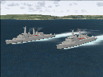
County Class Destroyers. Helicopter landable, provided in both static and AI form. Two versions are provided, Batch 1 with two 4.5in twin turrets, Sea Slug missiles, Sea Cat missiles and two 20mm Oerlikon, and Batch 2 conversion with Exocet in lieu of one turret.
Can be used alone or as escort to an Aircraft Carrier.
Both are provided with and without wake.
By Mike Hudson
| Filename: | County_Class_Destroyers.zip |
| License: | Freeware |
| Added: | 7th September 2011, 22:20:38 |
| Downloads: | 522 |
| Author: | Mike Hudson |
| Size: | 9.99 MB |
| Category: Flight Simulator X - Scenery | |
| CYCD Nanaimo-Collishaw Airport |
|
File Description:
This package adds detailed airport scenery to Nanaimo-Collishaw airport on beautiful Vancouver Island, BC, Canada. Included are accurate renderings of almost all buildings on the airport, cars and ground objects, detailed ground/taxiway layout and general aviation traffic in the new FSX format. Landclass scenery is also included to more accurately reflect the area around CYCD, including logging areas in the surrounding hills.
| Filename: | CYCD_NanaimoCollishaw_Airport.zip |
| License: | Freeware |
| Added: | 25th March 2009, 22:10:46 |
| Downloads: | 1,642 |
| Author: | Ken Peters |
| Size: | 3.15 MB |
| Category: Flight Simulator X - Scenery | |
| Alderney X-HD |
|
Images related to this file:
File Description:

Alderney is the smallest populated island in the cluster of Channel Islands, Again winds, fog and plenty of short runway makes for a very nice challenge. This scenery is perfect for VFR operations as it features the entire island of Alderney recreated in Photo-scenery. Also included are all the usual bells and whistles. This Scenery is perfect when joined with our other Channel Island products
| Filename: | Alderney_XHD.zip |
| License: | Freeware, limited distribution |
| Added: | 5th February 2017, 19:23:39 |
| Downloads: | 1,911 |
| Author: | Mark Piccolo - Soarfly Concepts |
| Size: | 127.09 MB |
| Category: Flight Simulator X - Scenery | |
| TACAN Replacements - Canada |
|
File Description:
By default, all of the TACAN navigational aids present within FSX have the bearing component turned off, so as to properly represent the real world result of tuning in the DME component of a TACAN with a civilian plane. However, this limits their functionality when you wish to use them in conjunction with a plane (generally military) equipped with a representation of a functioning TACAN system.
This download contains 12 modified TACAN and 1 modified VOR beacon found in Canada. 11 TACAN's have been updated to display azimuth / bearing information, 1 has been decommissioned, and 1 VOR has been updated to reflect it's status as a VOR/DME.
| Filename: | TACAN_Replacements__Canada.zip |
| License: | Freeware |
| Added: | 14th May 2014, 17:20:09 |
| Downloads: | 266 |
| Author: | Jim Stewart |
| Size: | 23.81 KB |
| Category: Flight Simulator X - Scenery | |
| 6I2 - Lebanon-Springfield Airport - Kentucky, USA |
|
Images related to this file:
File Description:
Lebanon-Springfield Airport (FAA LID: 6I2), a public use airport in Washington County, Kentucky (KY), USA. It is located three nautical miles (6 km) south of Springfield in Washington County) and north of Lebanon (in Marion County). The airport is owned by Marion and Washington Counties. The scenery contains seasonal ground textures for winter, spring, summer, autumn and night; autogen and default scenery objects of FSX plus a modified AFCAD file. Tested with FSX: SE on Windows 10. Version 1.1 contains fixes for the terrain aswell as corrected scenery objects.
** Do not use this version with FreeMesh X - USA; use 6I2_FMX.zip instead **
By Peregrine Simulations
| Filename: | 6I2__LebanonSpringfield_Airport__Kentucky_USA.zip |
| License: | Freeware, limited distribution |
| Added: | 21st February 2018, 23:36:38 |
| Downloads: | 250 |
| Author: | Peregrine Simulations |
| Size: | 104.1 MB |
| Category: Flight Simulator X - Scenery | |
| DL_NFI.zip |
|
File Description:
The Scenery includes a Fotoreal orientation of the "Nordfriesischen Inseln" in the north of Germany (North Sea) including the island Helgoland for the FSX.
The Scenery is based on Google Earth Satellite images.
Islands:
Sylt, Amrum, Föhr, Lageness, Hooge, Pellworm, Nordstrand and Helgoland .
Textures are partially with LOD 14 (2,4 m/pix) . The island Sylt is in LOD 13 (4.7 m/pix) .
Shore lines are included for Sylt (West coast) und Amrum (West coast).
In addition 6 Objects:
- Lighthouse from Hörnum (Sylt)
- Lighthouse from Kampen ( Sylt)
- Lighthouse from Amrum
- A ballon on the beach of Kampen (Sylt).
- Sheeps on the little island auf Hooge ( who can find them ?)
| Filename: | DL_NFIzip.zip |
| License: | Freeware |
| Added: | 4th October 2008, 20:36:37 |
| Downloads: | 7,286 |
| Author: | Dietmar Loleit |
| Size: | 12.65 MB |
| Category: Flight Simulator X - Scenery | |
| Lake Observation - Quebec bush scenery |
|
File Description:
This scenery is fictitious and created for the pleasure of all. All the objects are already included in FSX and no other library was used. In this scenery you can observe a weather complex. Many tests on modern equipments are made here. This scenery must be visited often for personnel changes. Lake observation is in the middle of the Manicouagan reservoir, Quebec, Canada.
Must have before installing the Aerovirtuel Quebec bush flying sceneries:
1-Quebec Elevation 38m (LOD10) Gilles Gauthier sur http://avsim.com/ 5 files.
2-Quebec Scenery - Lakes and Rivers (1/5) http://avsim.com/ 5 files and one fix
3-Quebec Scenery - Addition of Roads http://avsim.com/
| Filename: | Lake_Observation__Quebec_bush_scenery.zip |
| License: | Freeware, limited distribution |
| Added: | 9th November 2007, 22:26:31 |
| Downloads: | 1,060 |
| Author: | Denis Dupuis |
| Size: | 516.79 KB |
| Category: Flight Simulator X - Scenery | |
| Bob Quinn Lake (CBW4) |
|
File Description:
Bob Quinn Lake, British Columbia - CBW4 (FSX).
This is a fictitious RCMP Ranger Station and campground rendition of an actual airport in British Columbia, Canada. (CBW4)
I took a boring airport and added some "eye-candy" in order to have something nice to look at in addition to the spectacular mountains.
I created this for my own use but thought I would share it. This is the Third scenery creation of my British Columbia series.
This is freeware. I hope you enjoy it.
Designed with the FS X Sdk Scenery function of the Mission builder and the Abacus Scenery shortcut tool.
This scenery is frame rate freindly.
| Filename: | Bob_Quinn_Lake_CBW4.zip |
| License: | Freeware |
| Added: | 21st January 2007, 00:09:12 |
| Downloads: | 1,653 |
| Author: | Bob Caparoula |
| Size: | 1.92 MB |
| Category: Flight Simulator X - Scenery | |
| KHGR - Hagerstown Regional Airport - Hagerstown, MD |
|
File Description:
Here is an improved version of the stock Hagerstown Regional Airport. I adjusted and added aprons,
taxiways, and roads to more closely match real life. Most default buildings were replaced and many
other buildings added. I moved the control tower to the correct location. Added static vehicles,
aircraft, light poles, etc.
Allegiant Air flies in and out of Hagerstown and I assigned gates to them. The runway has been
lengthened in real life to 7000'. I lengthened the runway in FSX but it didn't fit between I-81 and
Rt. 11. So much for accurate roads. I ended up making it 6000' which is still longer than the stock
airport.
| Filename: | KHGR__Hagerstown_Regional_Airport__Hagerstown_MD.zip |
| License: | Freeware |
| Added: | 12th December 2008, 01:51:19 |
| Downloads: | 976 |
| Author: | Jim Cook |
| Size: | 11.79 KB |
| Category: Flight Simulator X - Scenery | |
| 6I2 - Lebanon-Springfield Airport - Kentucky, USA [FreeMeshX - USA-optimized] |
|
Images related to this file:
File Description:
Lebanon-Springfield Airport (FAA LID: 6I2), a public use airport in Washington County, Kentucky (KY), USA. It is located three nautical miles (6 km) south of Springfield in Washington County) and north of Lebanon (in Marion County). The airport is owned by Marion and Washington Counties. The scenery contains seasonal ground textures for winter, spring, summer, autumn and night; autogen and default scenery objects of FSX plus a modified AFCAD file. Tested with FSX: SE on Windows 10. Version 1.1 contains fixes for the terrain aswell as corrected scenery objects.
** Do not use this version with the default mesh; use 6I2_NO_FMX.zip instead **
By Peregrine Simulations
| Filename: | 6I2__LebanonSpringfield_Airport__Kentucky_USA_Free.zip |
| License: | Freeware, limited distribution |
| Added: | 21st February 2018, 23:36:13 |
| Downloads: | 414 |
| Author: | Peregrine Simulations |
| Size: | 104.1 MB |
© 2001-2026 AVSIM Online
All Rights Reserved
Privacy Policy |