
Where Flight Simulation Enthusiasts Gather from Around the World!
AVSIM Library - Search Results

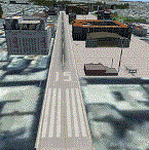
| Category: Flight Simulator X - Scenery | |
| AG6219 - Derryogue Airport, Kilkeel, Northern Ireland, UK |

|
Images related to this file:
File Description:
A "Better Than Default" scenery for FSX and FSX:SE of Derryogue Airport in Northern Ireland. See the README.txt file for details.
| Filename: | AG6219__Derryogue_Airport_Kilkeel_Northern_Ireland.zip |
| License: | Freeware |
| Added: | 19th August 2019, 17:04:45 |
| Downloads: | 236 |
| Author: | David Vega |
| Size: | 7.18 KB |
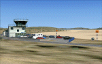
| Category: Flight Simulator X - Scenery | |
| LTCN Kahramanmaras Airport / Turkey |
|
File Description:
This is an Photoreal scenery of the Kahramanmaras Airport in Turkey that includes animated traffic.
The Airport is located at Anatolia.
| Filename: | LTCN_Kahramanmaras_Airport__Turkey.zip |
| License: | Freeware |
| Added: | 15th March 2012, 18:58:32 |
| Downloads: | 2,176 |
| Author: | Huseyin Buharali |
| Size: | 43.44 MB |
| Category: Flight Simulator X - Scenery | |
| LOWK Klagenfurt Airport |
|
Images related to this file:
File Description:
Afcad and scenery upgrade for Klagenfurt Airport (LOWK) austria. Made in ADE and very framerate friendy. Future updates may be possible.
| Filename: | LOWK_Klagenfurt_Airport.zip |
| License: | Freeware |
| Added: | 18th May 2010, 23:41:58 |
| Downloads: | 4,166 |
| Author: | John Daniels |
| Size: | 14.89 KB |
| Category: Flight Simulator X - Scenery | |
| VOHS-VOBL package for FSX and FSX-SE |
|
Images related to this file:
File Description: Rajiv Gandhi International Airport (IATA: HYD, ICAO: VOHS) is an international airport that serves Hyderabad,
the largest city in the Indian state of Telangana. It is located in Shamshabad, about 24 kilometres (15 mi) south of Hyderabad.
The airport is operated by GMR Hyderabad International Airport Ltd, a public–private venture.
It was opened in March 2008 to replace Begumpet Airport as the primary commercial airport for Hyderabad.
It is named after Rajiv Gandhi, former Prime Minister of India. _______________________________________________________________________________________ Kempegowda International Airport (IATA: BLR, ICAO: VOBL) is an international airport serving Bangalore, the capital of the Indian state of Karnataka.
Spread over 4,000 acres (1,600 ha), it is located about 40 kilometres (25 mi) north of the city near the village of Devanahalli.
It is owned and operated by Bangalore International Airport Limited (BIAL), a public–private consortium.
The airport opened in May 2008 as an alternative to increased congestion at HAL Airport,
the original primary commercial airport serving the city. It is named after Kempe Gowda I, the founder of Bangalore.
Kempegowda International Airport became Karnataka's first fully solar powered airport developed by CleanMax Solar.[2][3] As of 2016, Kempegowda Airport is the third-busiest airport by passenger traffic in the country,
behind the airports in Delhi, Mumbai and is the 35th-busiest airport in Asia. It handled over 22.2 million passengers in 2016 with little less than 500 aircraft movements a day.
The airport also handled about 314,060 tonnes (346,190 short tons) of cargo. By 2020, it is expected to handle at least 40 million passengers per year,
with 45 international airlines and more than 1000 aircraft movements per day.
| Filename: | VOHSVOBL_package_for_FSX_and_FSXSE.zip |
| License: | Freeware |
| Added: | 28th January 2018, 17:03:17 |
| Downloads: | 4,442 |
| Author: | morten thomas van der linden |
| Size: | 171.62 MB |
| Category: Flight Simulator X - Scenery | |
| X3SF- Snitterfield - Warwickshire, England |
|
File Description:
RAF Snitterfield (ICAO x3SF) is a former Royal Air Force station located west of Snitterfield, Warwickshire, England, 3.3 miles (5.3 km) north of Stratford-upon-Avon and 4.6 miles (7.4 km) south-east of Henley-in-Arden, Warwickshire.
RAF Snitterfield was operational during the Second World War, the airfield was a class A airfield and had around 30 aircraft dispersals. The airfield was finished around June 1942 and cost around £1,147,000 and opened in 1943 and with the cessation of hostilities the Air Ministry having no further use for the Station it closed in 1946.
Source: Wikipedia.
| Filename: | X3SF_Snitterfield__Warwickshire_England.zip |
| License: | Freeware |
| Added: | 14th May 2016, 11:42:00 |
| Downloads: | 108 |
| Author: | Terry Boissel |
| Size: | 1.54 MB |
| Category: Flight Simulator X - Scenery | |
| RAF Peplow - Shropshire, England |
|
File Description:
RAF Peplow (Child Ercall) X3PP is located 7 miles from Market Dayton, the Station started life as RAF Childs Ercall but this was changed to RAF Peplow in August 1943 to avoid confusion with a nearby stations called High Ercall.
The station follows the usual 3 runway pattern of the period, however, the technical site was unusual in that it was located in between 2 runways on the airfield side of the peri-track
There is plenty of information about the units that were stationed at the base available on the internet.
| Filename: | RAF_Peplow__Shropshire_England.zip |
| License: | Freeware |
| Added: | 6th January 2016, 15:19:11 |
| Downloads: | 223 |
| Author: | Terry Boissel |
| Size: | 1.15 MB |
| Category: Flight Simulator X - Scenery | |
| LGMM2 Athinaiko Airport |
|
Images related to this file:
File Description:
AS REAL AS IT GETS.
Athinaiko Airport.
Combined with AthensBlds2.
This revamped and completely refurbished version contains exclusion
polygons and ELEVATION CHANGE FILES which I forgot to upload with the original version.
In this version I have included a detailed photoscenery files of the surrounding area in case you haven't installed my Athens3 and Athens4 photoscenery.( It would work with or without my Athens photoscenery).
ALSO, I have combined a revamped and totally reworked AthensBlds scenery containing 135 original buildings in the surrounding area.
(A lot of work indeed)
IMPORTANT: See details bellow for installation instructions.
| Filename: | LGMM2_Athinaiko_Airport.zip |
| License: | Freeware |
| Added: | 2nd July 2011, 03:39:57 |
| Downloads: | 579 |
| Author: | Angelo Tassoglou |
| Size: | 149.52 MB |
| Category: Flight Simulator X - Scenery | |
| Charlestown Naval Auxiliary Air Station (KALF) |
|
File Description:
The Charlestown Naval Auxiliary Air Station (NAAS) was built by the Navy in 1942 in Charlestown, Rhode Island as a satellite to Quonset Naval Air Station. During world War II it was used to train night fighter squadrons on the F6F Hellcat and TBM Avenger. In the late 50s and early 60s it was used by the Coast Guard and for drag racing. The Navy closed Charlestown 1974. The Station is now part of Ninigret Park & Wildlife Refuge but the outlines of the runways can still be seen on satellite photos. The model recreates Charlestown NAAS as it was about 1945.
| Filename: | Charlestown_Naval_Auxiliary_Air_Station_KALF.zip |
| License: | Freeware |
| Added: | 28th May 2008, 02:27:27 |
| Downloads: | 706 |
| Author: | Fred Highland |
| Size: | 6.79 KB |
| Category: Flight Simulator X - Scenery | |
| Palmer USCG Helobase.zip |
|
Images related to this file:
File Description:
A fictitous USCG helo base located east of Palmer Municipal airport in Alaska. The scenery has a water runway, float plane dock, a repair area with a usable ramp up to a dry dock and repair hanger. Added two new bridges, two cargo docks, 9 helipads with one as a start point and many other additions to enhance your FS world. Test your skills as you fly in and taxi up to the ramp, then up to the dry dock without over shooting it and ending in the repair hanger. Lots of candies on the base for your flying pleasure. By savageagle......AW702_savag
| Filename: | Palmer_USCG_Helobasezip.zip |
| License: | Freeware |
| Added: | 26th May 2010, 03:35:08 |
| Downloads: | 602 |
| Author: | Tim Durham |
| Size: | 4.97 MB |
| Category: Flight Simulator X - Scenery | |
| EGPR - Barra - UK Airfields - Volume 27 v2 |
|
Images related to this file:
File Description:
My volume 27 is a version 2 of my Barra-EGPR, which is on the foreshore of Traigh Mhor Bay, Island of Barra, Outer Hebrides, Scotland. For this update of my 2008 Barra I have replaced the original Generic buildings with custom made ones.The FSX Stock Barra is wrongly placed in the middle of the north end of the island. Landings are actually done on the sand in Traigh Mhor Bay at low tide.
I also enclose a small mod to my Vol.26 Lashenden in case anyone is still having problems removing the black unpainted static aircraft.
| Filename: | EGPR__Barra__UK_Airfields__Volume_27_v2.zip |
| License: | Freeware |
| Added: | 14th March 2013, 14:17:48 |
| Downloads: | 2,666 |
| Author: | Alf Denham |
| Size: | 2.84 MB |
© 2001-2026 AVSIM Online
All Rights Reserved
Privacy Policy |