
Where Flight Simulation Enthusiasts Gather from Around the World!
AVSIM Library - Search Results

| Category: Flight Simulator X - Scenery | |
| Axalp / Ebenfluh |

|
Images related to this file:
File Description:
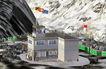
Axalp / Ebenfluh Shooting Range is unique in its location at 2200m above sea level in the Swiss Mountains, close to Meiringen AB. Each year during October, aviation enthusiasts make the arduous climb to enjoy this very special event. Scenery includes all buildings, targets, navaids, tower view, helicopter landing pads, animated flags and static helicopters. Requires FS Global 2008.
| Filename: | Axalp__Ebenfluh.zip |
| License: | Freeware |
| Added: | 22nd October 2010, 23:08:30 |
| Downloads: | 1,872 |
| Author: | Dave Torkington |
| Size: | 4.28 MB |
| Category: Flight Simulator X - Scenery | |
| Liverpool John Lennon (Speke) Airport (EGGP) Ver 5.0 Update |
|
File Description:
To use this package you will first need to install a full copy of Version 5.0 of the airport scenery. This update contains files that have been fixed to remove bugs that were reported in the initial version 5.0 release (I've also added some extra detail to give a taste of what to expect in version 5.1!).
| Filename: | Liverpool_John_Lennon_Speke_Airport_EGGP_Ver_50_Up.zip |
| License: | Freeware |
| Added: | 3rd December 2006, 19:50:58 |
| Downloads: | 6,087 |
| Author: | Paul Derbyshire |
| Size: | 13.27 KB |
| Category: Flight Simulator X - Scenery | |
| Cerval Airfield, Portugal - FSX SP2 |
|
File Description:
Scenery of the Cerval Airfield, located near Valença do Minho, in the northern border between Portugal and Spain. For FSX SP2 and not compatible with my other previous work. It includes an area of 20x20 km of terrain completely redrawn from scratch.
Because the Airfield has not officially attributed ICAO code, in the scenery is accessible as "LPCE".
| Filename: | Cerval_Airfield_Portugal__FSX_SP2.zip |
| License: | Freeware, limited distribution |
| Added: | 25th September 2008, 00:29:11 |
| Downloads: | 1,829 |
| Author: | José Maia |
| Size: | 6.01 MB |
| Category: Flight Simulator X - Scenery | |
| Radissonie Project |
|
Images related to this file:
File Description:
This set of files is intended to enhance the Radissonie area located on the center North part of Quebec, where dams have been erected on the La Grande river and surroundings. You must have installed Ultimate Terrain X Canada in order to have a fairly good mapping of the area. French and English instructions in the readme files.
| Filename: | Radissonie_Project.zip |
| License: | Freeware |
| Added: | 26th November 2009, 16:28:42 |
| Downloads: | 597 |
| Author: | Pierre Fauteux |
| Size: | 49.89 KB |
| Category: Flight Simulator X - Scenery | |
| FSX Northern Namibian Airfields |
|
Images related to this file:
File Description:
These are airports in the northern part of Namibia that was used by the South African Air Force in the Border War of the 70's and 80's with Angola. They are made from default FSX objects with correct AFCAD files. Best with SP2 or Accelleration installed. They include Grootfontein, Ondangwa, Rundu and Katima Molilu.
| Filename: | FSX_Northern_Namibian_Airfields.zip |
| License: | Freeware |
| Added: | 23rd December 2010, 02:12:41 |
| Downloads: | 385 |
| Author: | Jacques Botha |
| Size: | 98.44 KB |
| Category: Flight Simulator X - Scenery | |
| FIX for Ship Wakes for <b><span style="color:red">P3Dv2.5</span></b> - version 2 |
|
Images related to this file:
File Description:

This file includes a complete replacement of the effect files included in my all AI shipping packages to date. It corrects the issue of wakes going towards the sky in P3Dv2.5. You do not need this file for earlier versions of P3D than P3Dv2.5.
Specially designed for P3D v2.5
| Filename: | FIX_for_Ship_Wakes_for_bspan_stylecolorredP3Dv25sp.zip |
| License: | Freeware |
| Added: | 4th March 2015, 18:09:23 |
| Downloads: | 3,501 |
| Author: | Henrik Nielsen |
| Size: | 236.92 KB |
| Category: Flight Simulator X - Scenery | |
| North Sea (Belgium) |
|
Images related to this file:
File Description:

FSX North Sea Scenery places several ships in the North Sea, in front of the Belgian coast. Features tankers, passenger boats, fishing vessels and military cruisers. Most of them are landable! Can be used for SAR or naval operations. Created with SDK/FSX Acceleration Pack (SP2), don't know if this works with other versions. By Bert D'Hondt, Belgium.
| Filename: | North_Sea_Belgium.zip |
| License: | Freeware |
| Added: | 24th April 2011, 14:03:06 |
| Downloads: | 2,539 |
| Author: | Bert D'Hondt |
| Size: | 697.01 KB |
| Category: Flight Simulator X - Scenery | |
| Penn Valley-Sunbury Airports |
|
Images related to this file:
File Description:
FSX Scenery - Here are three nice airports all within a few miles of each other. Located in the state of Pennsylvania, USA. These are some fun airports to fly in and out of. Please enjoy Penn Valley Airport, KSEG, Sunbury Airport, 71N and Sunbury Seaplane Base, H11. For your flying pleasure by John B. Loney, Jr.
| Filename: | Penn_ValleySunbury_Airports.zip |
| License: | Freeware, limited distribution |
| Added: | 18th August 2016, 03:56:04 |
| Downloads: | 336 |
| Author: | John B. Loney, Jr. |
| Size: | 60.49 MB |
| Category: Flight Simulator X - Scenery | |
| KDMW - Carroll County Regional Airport - Westminster, Maryland (USA) |
|
Images related to this file:
File Description:
Carroll County Regional Airport is an airport roughly on the edge of the town of Westminster, in Carroll County, Maryland (MD), USA. This quiet little airport is home to many general aviation flights in the mid-Maryland area. Using photo-realistic ground textures and moving hangars and static aircraft, this is a low frame impact high quality scenery
| Filename: | KDMW__Carroll_County_Regional_Airport__Westminster.zip |
| License: | Freeware |
| Added: | 29th April 2013, 16:12:26 |
| Downloads: | 538 |
| Author: | Tom Neubauer |
| Size: | 10.88 MB |
| Category: Flight Simulator X - Scenery | |
| ZULS, Lhasa/Gonggar Airport, Tibet |
|
Images related to this file:
File Description:
Complete new setup. Lhasa/Gonggar Airport is 62km (39ml) from Lhasa, the capital of Tibet. It lies at an altutude of 3500m (11500ft) and is one of the highest airports in the world. It is build on the banks of the Yarlung Tsangpo River (Brahmaputra River) that is very wide at that point (not included in this scenery).
| Filename: | ZULS_LhasaGonggar_Airport_Tibet.zip |
| License: | Freeware |
| Added: | 17th August 2018, 16:36:31 |
| Downloads: | 954 |
| Author: | Tim van Ringen |
| Size: | 2.37 MB |
© 2001-2026 AVSIM Online
All Rights Reserved
Privacy Policy |