
Where Flight Simulation Enthusiasts Gather from Around the World!
AVSIM Library - Search Results

| Category: Flight Simulator X - Scenery | |
| UK Airfields - Reymerston Hall - Norfolk, UK Vol. 31 ** UPDATE ** |

|
Images related to this file:
File Description:
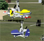
Reymerston Hall Update. I managed to track down two FSX Wallis Autogyros by John Hauk. I was unable to track him down so I hope he will forgive me for using them in my scenery. I have also added the second parking place that I mentioned in my original ReadMe but never included.
| Filename: | UK_Airfields__Reymerston_Hall__Norfolk_UK_Vol_31__.zip |
| License: | Freeware |
| Added: | 8th July 2015, 13:50:09 |
| Downloads: | 363 |
| Author: | Alf Denham |
| Size: | 1.02 MB |
| Category: Flight Simulator X - Scenery | |
| BIRDS Volume 2 Dolphin Bay ,Hawaii |
|
File Description:
I am not sure there is a "Dolphin bay" in Hawaii... never been there except in my dreams.
But now we have a virtual one with elegant dolphins jumping around.
So, why is this file called BIRDS if it adds dolphins??
Well...I don't know but anyway, I hope you'll like it :-))
| Filename: | BIRDS_Volume_2_Dolphin_Bay_Hawaii.zip |
| License: | Freeware, limited distribution |
| Added: | 18th January 2007, 15:47:59 |
| Downloads: | 2,911 |
| Author: | David Roch |
| Size: | 444.19 KB |
| Category: Flight Simulator X - Scenery | |
| SKPE Matecana International Airport |
|
File Description:
Matecana International Airport (Spanish: Aeropuerto Internacional de Matecana) (IATA: PEI, ICAO: SKPE) is an airport located in the city of Pereira, Colombia. It connects the Risaralda department of Colombia. It also serves the cities of Armenia, Cartago, and Manizales in emergency situations.
This file has the right coordenates and characteristics of the airport.
| Filename: | SKPE_Matecana_International_Airport.zip |
| License: | Freeware |
| Added: | 22nd October 2011, 23:58:14 |
| Downloads: | 2,344 |
| Author: | Anwar Gonzalez |
| Size: | 14.4 KB |
| Category: Flight Simulator X - Scenery | |
| KMSL, Northwest Alabama Regional Airport |
|
File Description:
Northwest Alabama Regional Airport (IATA: MSL, ICAO: KMSL, FAA LID: MSL) is located 1 nautical mile (2 km) east of Muscle Shoals, in Colbert County, Alabama. The airport is used for general aviation and is served by one airline. This scenery was made with ADE9x, several changes have had the airport since FSX came out, these changes and some additions have been added to this scenery, new twys and parkings spots were added as well, due to diagram airport chart is not available in web, new twys were named as E (Echo) and F (Foxtrot). If someone flies constantly here in real, please let me know what are the correct names of these twys, changes will be included in next version and uploaded immediately.
| Filename: | KMSL_Northwest_Alabama_Regional_Airport.zip |
| License: | Freeware |
| Added: | 14th May 2017, 07:25:22 |
| Downloads: | 271 |
| Author: | Camilo Conte |
| Size: | 12.24 MB |
| Category: Flight Simulator X - Scenery | |
| F45 - North Palm Beach County General Aviation Airport - West Palm Beach, Florida (USA) |
|
Images related to this file:
File Description:
North Palm Beach County Airport, located northwest of West Palm Beach, Florida, was opened in 1994 as a designated reliever for KPBI. All of the buildings have been custom modeled in accordance with information available on the internet including Microsoft Bing birdseye views. The airport layout and landclass changes are in accordance with Google Earth imagery.
If you have Jim Dhaenens' lightobj.bgl installed, apron lighting will be included, and if you have KB_static_aircraft_FSX installed (available at www.kb-sim.com/screens_static_aircraft.html), additional parked aircraft will be visible.
The layout of scenery is optimized for use with Ultimate Terrain X-USA. There is no FAA airport diagram for this airport, but a taxiway diagram provided by the local Airport Authority is included in this package.
| Filename: | F45__North_Palm_Beach_County_General_Aviation_Airp.zip |
| License: | Freeware |
| Added: | 22nd August 2013, 20:48:03 |
| Downloads: | 1,150 |
| Author: | Art Poole |
| Size: | 1.27 MB |
| Category: Flight Simulator X - Scenery | |
| RAF Chalgrove - Oxfordshire ,England |
|
File Description:
Chalgrove Airfield (ICAO: EGLJ) is a former Second World War airfield in Oxfordshire, England. The airfield is located approximately 3 mi (4.8 km) north-northeast of Benson; about 42 mi (68 km) north-northwest of London.
Opened in 1943, it was used by both the Royal Air Force and United States Army Air Forces. During the war it was used primarily as a combat reconnaissance airfield. It was closed in late 1946 and today, the airfield is primarily used by the Martin-Baker company for testing ejector seats. Source: Wikipedia.
| Filename: | RAF_Chalgrove__Oxfordshire_England.zip |
| License: | Freeware |
| Added: | 27th February 2016, 21:52:35 |
| Downloads: | 327 |
| Author: | Terry Boissel |
| Size: | 1.96 MB |
| Category: Flight Simulator X - Scenery | |
| RAF High Ercall - Staffordshire, England |
|
File Description:
RAF High Ercall is a former Royal Air Force station situated near the village of High Ercall, seven miles north-east of Shrewsbury.
It was a post expansion station with work starting in 1938, however, personnel started arriving before it was fully finished in 1940. The unit had a variety of permanent buildings mainly located on the main unit site and the temporary accommodation and sick quarters were located on the south of the airfield.
The station closed for good in February 1962. Source: Wikipedia.
| Filename: | RAF_High_Ercall__Staffordshire_England.zip |
| License: | Freeware |
| Added: | 18th December 2015, 23:37:52 |
| Downloads: | 226 |
| Author: | Terry Boissel |
| Size: | 2.03 MB |
| Category: Flight Simulator X - Scenery | |
| RAF Woodhall Spa - Lincolnshire, England |
|
File Description:
RAF Woodhall Spa opened in February 1942 and was typical of bomber stations of the time in Lincolnshire. The station was located south west of the town from where it got its name. The Station closed for flying at the end of WW11 and finished with the RAF in the 60s when 2 Squadrons of the surface to air missiles of Bloodhounds were relocated. It is now the site of a holiday park. Scenery objects loaded from Ted Andrews scenery libraries, RAF Control Towers and RAF Hangers. Both can be found at http://www.ianpsdarkcorner.co.uk.
| Filename: | RAF_Woodhall_Spa__Lincolnshire_England.zip |
| License: | Freeware |
| Added: | 25th September 2015, 13:51:12 |
| Downloads: | 208 |
| Author: | Terry Boissel |
| Size: | 12.38 KB |
| Category: Flight Simulator X - Scenery | |
| RAF Bardney |
|
File Description:
RAF Barney is a former Royal Air Force station located 1.7 miles (2.7km) north of Bardney, Lincolnshire, England and 10.2 miles (16.4km) east of the County town of Lincoln. It was built as a satellite to RAF Waddington in 1943 and the airfield closed in 1963.
I would like to give credit and to acknowledge the following authors without whose work I could not have made this scenery; all credit for the models contained in it is theirs I merely placed it. Ted Andrews - Ian Pearson - Mike Hudson.
| Filename: | RAF_Bardney.zip |
| License: | Freeware |
| Added: | 3rd October 2015, 18:49:54 |
| Downloads: | 466 |
| Author: | Terry Boissel |
| Size: | 334.31 KB |
| Category: Flight Simulator X - Scenery | |
| Alesund 10m Mesh |
|
File Description:
Alesund 10 metre mesh for FSX only.
Alesund is found on the West coast of Norway. (The same as most other populated places in Norway!)
This is near 10m mesh, which Jonathan de Ferranti of: http://www.viewfinderpanoramas.org/ has kindly allowed me to turn into a BGL for use in Microsoft FSX.
The coverage isn't all that large: From 007 East Longitude to 009 East Longitude, 61 North Latitude to 62 North Latitude. (Points on SW corner of each Lat/Long box) Area is in the shape of a 'T'.
| Filename: | Alesund_10m_Mesh.zip |
| License: | Freeware |
| Added: | 10th March 2009, 16:44:28 |
| Downloads: | 1,129 |
| Author: | Wayne Evans |
| Size: | 62.48 MB |
© 2001-2026 AVSIM Online
All Rights Reserved
Privacy Policy |