
Where Flight Simulation Enthusiasts Gather from Around the World!
AVSIM Library - Search Results

| Category: Flight Simulator X - Scenery | |
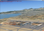
| PGUM - Guam airport (Part 2) |

|
File Description:
Antonio B. Won Pat International Airport (IATA: GUM, ICAO: PGUM), is an airport located in Tamuning and Barrigada, three miles east of the capital city of Agana in the United States territory of Guam.
***requires Guam airport part1.zip and Guam airport part3.zip***
| Filename: | PGUM__Guam_airport_Part_2.zip |
| License: | Freeware |
| Added: | 15th September 2012, 22:18:24 |
| Downloads: | 3,405 |
| Author: | morten van der linden |
| Size: | 104.19 MB |
| Category: Flight Simulator X - Scenery | |
| Rajkot VARK Gujarat |
|
Images related to this file:
File Description:
Small regional airport located near city of Rajkot in Gujarat province, India. Scenery is very accurate according to the latest charts and satellite images. Photo background blends nicely into ORBX Global.
Made for P3Dv3, should work in FSX:SE, FSX and P3Dv4. Made by Dmitriy Kozyrev.
| Filename: | Rajkot_VARK_Gujarat.zip |
| License: | Freeware |
| Added: | 25th August 2017, 02:51:06 |
| Downloads: | 1,057 |
| Author: | Dmitriy Kozyrev |
| Size: | 11.84 MB |
| Category: Flight Simulator X - Scenery | |
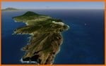
| Balear Islands |
|
Images related to this file:
File Description:
This had been the last scenery design that I had made for Fs2004 before the appearance in the markets the new FsX and for my own pleasure and residents in the islands. I wanted to represent it as accurately as possible with 100% of detail
| Filename: | Balear_Islands.zip |
| License: | Freeware |
| Added: | 31st August 2010, 21:22:37 |
| Downloads: | 7,117 |
| Author: | Toni Agramont |
| Size: | 18.4 MB |
| Category: Flight Simulator X - Scenery | |
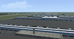
| ZPZT - Zhaotong Airport |
|
Images related to this file:
File Description:
A frame-friendly rendition of Zhaotong Airport serving the city of Zhaotong in Yunnan province, southwestern China. This airport is not included in FSX or P3D's default scenery. It's compatible with FSX (all versions) and P3Dv1..3. See the README.txt file for more information.
| Filename: | ZPZT__Zhaotong_Airport.zip |
| License: | Freeware, limited distribution |
| Added: | 19th October 2023, 12:09:37 |
| Downloads: | 143 |
| Author: | David Vega |
| Size: | 338.94 KB |
| Category: Flight Simulator X - Scenery | |
| EDDM - Munich Airport - Munich, Germany |
|
Images related to this file:
File Description:
Frame rate friendly version of MUC (EDDM). All gates are on the exact position, have working jetways (if so in reality) and ground numbers. Taxiways are exact. ILS frequencies are current. Approach lights work in low visibility. More information on https://sites.google.com/site/fsxvideosairports/.
| Filename: | EDDM__Munich_Airport__Munich_Germany.zip |
| License: | Freeware |
| Added: | 13th February 2017, 19:22:16 |
| Downloads: | 8,438 |
| Author: | Rene Scharlach |
| Size: | 1.19 MB |
| Category: Flight Simulator X - Scenery | |
| Resized Autogen Textures |
|
File Description:
This release includes resized textures for autogen buildings in FSX.
Textures were resized from 1024x1024 to 512x512, cutting filesize from 683kb to 171kb each.
All resized textures have mip-maps included and are in DDS format.
Resized textures decrease loading time and increase framerate (FPS).
| Filename: | Resized_Autogen_Textures.zip |
| License: | Freeware, limited distribution |
| Added: | 1st November 2006, 10:37:07 |
| Downloads: | 44,295 |
| Author: | Bart Dylkiewicz |
| Size: | 6.31 MB |
| Category: Flight Simulator X - Scenery | |
| St Eustatius, Caribbean, PhotoScenery V2 |
|
Images related to this file:
File Description:
St Eustatius, Caribbean, PhotoScenery V2 with added Valladier Tower and Terminal.
Photo scenery of St.Eustatius (Statia) in the Caribbean with the airport F.D. Roosevelt (TNCE) in Oranjestad. JL Valladier's model of terminal, tower and PIR included with permission. This file also includes updates and mesh.
| Filename: | St_Eustatius_Caribbean_PhotoScenery_V2.zip |
| License: | Freeware |
| Added: | 11th December 2012, 17:33:53 |
| Downloads: | 3,331 |
| Author: | Harald Sandvik |
| Size: | 63.43 MB |
| Category: Flight Simulator X - Scenery | |
| X3SY - RAF Saltby - Leicestershire, England |
|
File Description:
RAF Saltby (ICAO X3SY)was a World War II airfield in Leicestershire, England. The airfield is located approximately 8 miles (13 km) northeast of Melton Mowbray; about 90 miles (140 km) north-northwestof London.
It was opened in 1942, and was used by both the Royal Air Force and United States Army Air Forces. During the war it was used primarily as a transport airfield. Like many airfields of the time it closed after the war in 1945 but kept in reserve until 1955.
Today the remains of the airfield are located on private property and, now known as Saltby Airfield, is used primarily for gliding.
Source: Wikipedia
| Filename: | X3SY__RAF_Saltby__Leicestershire_England.zip |
| License: | Freeware |
| Added: | 27th April 2016, 15:39:01 |
| Downloads: | 130 |
| Author: | Terry Boissel |
| Size: | 1.36 MB |
| Category: Flight Simulator X - Scenery | |
| RAF Staplehurst - Kent, England |
|
File Description:
RAF Staplehurst is a former World War II airfield in Kent, England. The airfield is located approximately 1 mile (1.6 km) northeast of Staplehurst; about 38 miles (61 km) southeast of London.
Opened in 1943, Staplehurst was a prototype for temporary Advanced Landing Grounds built in France after D-Day, and as the Allied forces moved east across France and Germany. It was used by the Royal Air Force, Canadian and the United States Army Air Forces. It was closed in September 1944.
Today the airfield is a mixture of agricultural fields with no recognizable remains, except a memorial now near the site.
| Filename: | RAF_Staplehurst__Kent_England.zip |
| License: | Freeware |
| Added: | 1st May 2016, 20:56:55 |
| Downloads: | 158 |
| Author: | Terry Boissel |
| Size: | 1.25 MB |
| Category: Flight Simulator X - Scenery | |
| X2CB - RAF Chilbolton - Hampshire, England |
|
File Description:
RAF Chilbolton (ICAO X2CB) is a former Royal Air Force station in Hampshire, England. The airfield is located in Chilbolton approximately 4 miles (6.4 km) south-southeast of Andover; about 62 miles (100 km) southwest of London Opened in 1940, it was used by both the Royal Air Force and then later by the United States Army Air Forces. During the war it was used primarily as a troop carrier airfield for parachutists. After the war it was used for jet aircraft testing before being closed in 1946. Today the remains of the airfield are located on private property being used as agricultural fields.
| Filename: | X2CB__RAF_Chilbolton__Hampshire_England.zip |
| License: | Freeware |
| Added: | 1st April 2016, 08:06:40 |
| Downloads: | 115 |
| Author: | Terry Boissel |
| Size: | 2.77 MB |
© 2001-2026 AVSIM Online
All Rights Reserved
Privacy Policy |