
Where Flight Simulation Enthusiasts Gather from Around the World!
AVSIM Library - Search Results

| Category: Flight Simulator X - Scenery | |
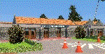
| YLGB Bidyadanga (La Grange Bay), Western Australia |

|
File Description:
YLGB Bidyadanga (La Grange Bay), the largest aboriginal community in WA has a population of 500 people and is situated 190km south of Broome. This is the traditional country of the Karajarri People who had their native title acknowledged by the Federal Court of Australia in 2003. Facilities in the community of Bidyadanga include a large community store, fuel outlet, multi-functional police unit, school, telecentre, and a community swimming pool completed in 2007. REQUIRES Blencowe_LibraryKit.zip
REQUIRES blencowe_librarykit_309494.zip (Available HERE)
| Filename: | YLGB_Bidyadanga_La_Grange_Bay_Western_Australia.zip |
| License: | Freeware |
| Added: | 28th February 2013, 13:55:11 |
| Downloads: | 221 |
| Author: | Alan Blencowe |
| Size: | 3.66 MB |
| Category: Flight Simulator X - Scenery | |
| Neujellingsdorf / Fehmarn, Germany |
|
Images related to this file:
File Description:
This small private Airstrip is situated on the island of Fehmarn in northern Germany. It does not exist in the standard FSX. Because this strip does not have an ICAO-code I created one: ED01. Under this code you can find the airstrip in the FSX airport list.
I edited a photo-based background featuring all four seasons, although this airstrip is closed during the winter in real life.
During the summerseason it is mainly used for sightseeing trips over Fehmarn with a C172 offered by the one-aircraft-company "Fehmarn Air" (http://www.fehmarn-air.de/).
| Filename: | Neujellingsdorf__Fehmarn_Germany.zip |
| License: | Freeware |
| Added: | 16th January 2016, 19:47:48 |
| Downloads: | 456 |
| Author: | Wolfgang Allers |
| Size: | 26.92 MB |
| Category: Flight Simulator X - Scenery | |
| BATANES X v1.0 |
|
Images related to this file:
File Description:
BATANES X v1.0
Archive includes the Photoreal Scenery of Batanes Island, Itbayat Island and its airports
(SLOPING RUNWAY NOT INCLUDED!)
Basco Airport (IATA: BSO, ICAO: RPUO) is an airport serving the province of Batanes in the Philippines. It is located in the provincial capital, Basco, and is one of two airports in the Batanes Islands, the other being Itbayat Airport. The airport is classified as a Class 2 principal (minor domestic) airport by
the Civil Aviation Authority of the Philippines (CAAP), a body of the Department of Transportation and Communications that is responsible for the operations of not only this airport but also of all other airports in the Philippines
except the major international airports.
Jorge Abad Airport (ICAO: RPLT), also known as Itbayat Airport, is an airport serving the island of Itbayat, the largest island in the province of Batanes, Philippines. The province's only other airport, Basco Airport, is located in the provincial capital, Basco, on Batan Island.
| Filename: | BATANES_X_v10.zip |
| License: | Freeware, limited distribution |
| Added: | 24th January 2019, 17:49:19 |
| Downloads: | 1,682 |
| Author: | Aeron M. Tumanut |
| Size: | 28.06 MB |
| Category: Flight Simulator X - Scenery | |
| EGXJ - RAF Cottesmore - Rutland, England |
|
File Description:
RAF Cottesmore (ICAO EGXJ) is a former Royal Air Force station in Rutland, England, situated between Cottesmore and Market Overton.
The Stationed opened on 11 March 1938 and was used mainly for training, and the first squadrons were equipped with Vickers Wellesley aircraft, but soon converted to Fairey Battles. Later RAF Bomber Command took over the airfield, again as a training station, flying Handley Page Hampdens. These units remained in residence until a few days before the outbreak of war in 1939 when they were sent to RAF Cranfield to serve as a pool providing replacements for combat losses. Their place at Cottesmore was taken by Nos. 106 and 185 Squadrons, moving in from RAF Thornaby with Hampdens. However, with the outbreak of war, the aircraft and crews were sent to locations in the north and west, as enemy air attacks were expected over the southern half of England. As these never materialised, the Hampdens returned in the spring of 1940 and No. 185 Squadron became the Hampden operational training unit, No. 14 Operational Training Unit RAF.
RAF Cottesmore's Hampdens' first trespass into hostile airspace was a leaflet dropping operation over northern France. In October 1940, 106 Squadron moved to RAF Finningley while No. 14 OTU remained training crews for Bomber Command, its Hampdens and HP.53 Herefords being replaced by Vickers Wellingtons in 1942. Training continued for three years and three months until August 1943 when No. 14 OTU moved to RAF Market Harborough.
In early December 2009, it was announced the station would close due to funding cut-backs, in part to help pay for additional helicopters for British operations in Afghanistan.
In 2010, No. 4 Squadron RAF disbanded, with No. 20 Squadron RAF re-badging as No 4 (Reserve) Squadron.
The station became a satellite to RAF Wittering on 31 March 2011 with a civic parade and flypast to mark the disbandment of No 1 Sqn RAF, 800 NAS, 801 NAS and JFH.
In July 2011 Defence Secretary Liam Fox announced plans for it to be the airfield for one of five of the Army's Multi-Role Brigades. In April 2012 it was renamed Kendrew Barracks after Major General Sir Douglas Kendrew.
Source: Wikipedia
| Filename: | EGXJ__RAF_Cottesmore__Rutland_England.zip |
| License: | Freeware |
| Added: | 19th March 2016, 12:15:07 |
| Downloads: | 344 |
| Author: | Terry Boissel |
| Size: | 1.66 MB |
| Category: Flight Simulator X - Scenery | |
| RAF Barkston Heath - 1944 |
|
File Description:
At the time of its construction, RAF Barkston Heath in common with a number of other airfields in the Grantham area had been planned for the RAF's No. 7 Group. In late 1943, Barkston Heath was made available to the United States Army Air Forces Ninth Air Force and designated as USAAF station 483. It was earmarked for basing troop carrier units scheduled to be transferred from Sicily to participate in the forthcoming cross-Channel invasion, Operation "Overlord"
American 61 TCG aircraft based at Barkston Heath carried British paratroops on the ill-fated operation Market Garden.
The USAAF returned control of the airfield to the Air Ministry in June 1945 when the war in Europe ended. Barkston Heath was used by No 256 Maintenance Unit and No 2 RAF Regiment. Beginning in May 1948.,
RAF Barkston Heath has the Naval and Army Elements of No. 3 Flying Training School (3 FTS) which, for a period between approximately 1995-2010 operated the Slingsby T67M260 Firefly two-seat trainer. The school now operates the Grob Tutor T1. A secondary role of RAF Barkston Heath is as a Relief Landing Ground for the flying training activities at RAF Cranwell.
Source: Wikipedia
| Filename: | RAF_Barkston_Heath__1944.zip |
| License: | Freeware |
| Added: | 10th March 2017, 07:13:15 |
| Downloads: | 150 |
| Author: | Terry Boissel |
| Size: | 1.05 MB |
| Category: Flight Simulator X - Scenery | |
| SKBO 2011 |
|
File Description:
El Dorado International Airport (IATA: BOG, ICAO: SKBO) is an international airport located in Bogota, Colombia. It is the largest Latin America airport in terms of cargo movements with 593,946 tons (2010) and the third in terms of passenger traffic, only behind Sao Paulo-Guarulhos International Airport and Mexico City's Benito Juarez International Airport, transporting 18,934,203 passengers in 2010; as well as the largest airport in Colombia and the main international and domestic air gateway in the country, serving as an important hub for Avianca, Copa Airlines Colombia, Aires, Satena, EasyFly and other cargo companies.
This file has the right coordinates, with the apron and characteristics of the airport. The runways were reoriented to the correct direction, runway were resized the gates placed on correct location and number, CATAM was placed (Colombian Air force and Colombian National Army) and Colombia National Police and Colombian National Armada were assigned a correct apron. All the jet ways including the ones of the executive terminal are working. There is a copy of all the airport charts required to navigate in and out of this airport which are courtesy of: Areonatica Civil de Colombia
| Filename: | SKBO_2011.zip |
| License: | Freeware |
| Added: | 29th June 2011, 21:16:37 |
| Downloads: | 2,942 |
| Author: | Anwar Gonzalez |
| Size: | 14.34 MB |
| Category: Flight Simulator X - Scenery | |
| ATAP - Rohnerville Airport (KFOT) |
|
Images related to this file:
File Description:

Toposim Airport Terrain Adjustment Pack (ATAP) for Rohnerville Airport (KFOT) in Fortuna, California.
| Filename: | ATAP__Rohnerville_Airport_KFOT.zip |
| License: | Freeware |
| Added: | 15th July 2013, 17:44:47 |
| Downloads: | 305 |
| Author: | Justin Tyme - Toposim |
| Size: | 1.62 MB |
| Category: Flight Simulator X - Scenery | |
| Mt. APO Airport |
|
Images related to this file:
File Description:
A fictional Airport at the base camp of Lake Venado in Mt. Apo.
| Filename: | Mt_APO_Airport.zip |
| License: | Freeware |
| Added: | 8th December 2017, 14:53:29 |
| Downloads: | 100 |
| Author: | Emilio Comiling |
| Size: | 11.92 MB |
| Category: Flight Simulator X - Scenery | |
| LI40 - Montagnana Airfield - Padova, Italy |
|
Images related to this file:
File Description:
Scenery for the Airfield of Montagnana (LI40) in the northern of Italy. Enjoy!
| Filename: | LI40__Montagnana_Airfield__Padova_Italy.zip |
| License: | Freeware |
| Added: | 22nd April 2016, 10:46:00 |
| Downloads: | 233 |
| Author: | Carlo Boninsegna |
| Size: | 29.77 MB |
| Category: Flight Simulator X - Scenery | |
| ATAP - Degali Airport (ENDI) |
|
Images related to this file:
File Description:

Toposim Airport Terrain Adjustment Pack (ATAP) for Degali Airport (ENDI) in Buskerud, Norway.
| Filename: | ATAP__Degali_Airport_ENDI.zip |
| License: | Freeware |
| Added: | 15th July 2013, 17:45:03 |
| Downloads: | 622 |
| Author: | Justin Tyme - Toposim |
| Size: | 944.44 KB |
© 2001-2026 AVSIM Online
All Rights Reserved
Privacy Policy |