
Where Flight Simulation Enthusiasts Gather from Around the World!
AVSIM Library - Search Results

| Category: Flight Simulator X - Scenery | |
| UK Airfields - Reymerston Hall and Shipdham - Norfolk, UK Vol. 31 |

|
Images related to this file:
File Description:
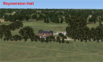
Vol.31 consists of Reymerston Hall and Shipdham EGSA in Norfolk and is a small tribute to Wing Commander Ken Wallis and his Wallis Gyrocopters. Reymerston Hall was his home in Norfolk where he flew his gyrocopters and where he died in 2013 at the age of 97. The local flying club was based at Shipdham, less than 2 miles away. One of his aircraft, 'Little Nellie', was used and flown by him in the James Bond film 'You Only Live Twice'.
| Filename: | UK_Airfields__Reymerston_Hall_and_Shipdham__Norfol.zip |
| License: | Freeware |
| Added: | 26th June 2015, 07:37:26 |
| Downloads: | 443 |
| Author: | Alf Denham |
| Size: | 3.86 MB |
| Category: Flight Simulator X - Scenery | |
| SKMD - Enrique Olaya Herrera Airport |
|
File Description:
Enrique Olaya Herrera Airport (Spanish: Aeropuerto Enrique Olaya Herrera) (IATA: EOH, ICAO: SKMD) is an airport located in MedellÃ�ÂÂn, Antioquia, Colombia is an airport located in Colombia's south-west of the city of MedellÃ�ÂÂn, which serves regional and domestic flights in that country. Additionally, more is the airport hangars and general aviation in Colombia. Due to the large number of general aviation and charter flights, regional and national, the Olaya Herrera is the second busiest airport in Colombia.
This file has the right coordinates, with the apron and characteristics of the airport. The runway and runways were resized, the gates placed on correct location.
| Filename: | SKMD__Enrique_Olaya_Herrera_Airport.zip |
| License: | Freeware |
| Added: | 17th February 2011, 02:09:59 |
| Downloads: | 569 |
| Author: | Anwar Gonzalez |
| Size: | 27.22 KB |
| Category: Flight Simulator X - Scenery | |
| Australis Operations Center |
|
Images related to this file:
File Description:
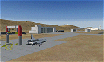
Australis is a joint private/military operations center located near Alice Springs in the Australian outback. It is the main base of operations of Aeroworks Technologies in the eastern hemisphere and conducts military missions in the far east of the globe. It acts very much the same as a normal AFB except that it is outside the US boundaries, and lies in a canyon very near the NSA Pine Gap facility. Occasionally some Russian and Chinese-built aircraft are trafficked through here. It also doubles as a spaceport and has shuttle recovery facilities similar to the ones in Railroad Valley. Scenery by Austin Gardner and Mike Vivaldi.
| Filename: | Australis_Operations_Center.zip |
| License: | Freeware |
| Added: | 14th August 2014, 01:28:31 |
| Downloads: | 824 |
| Author: | Austin Gardner |
| Size: | 27.7 MB |
| Category: Flight Simulator X - Scenery | |
| Centrair RJGG V3.0 complete |
|
Images related to this file:
File Description:
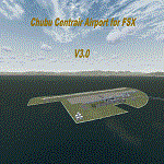
Chubu Centrair International Airport (IATA: NGO, ICAO: RJGG) is an airport on an artificial island in Ise Bay, 22 miles south of Nagoya in central Japan. Chubu is Japan's third off-shore airport, after Nagasaki Airport and Kansai International Airport, and is also the second airport built in Japan on a man-made island.
In this final version are added:
cars on parking garages
parking areas
static Air stairs
more realistic bagage loader
ANA logo on ground vehicles
Changed Skychefs catering trucks to NAC ( Nagoya Air Catering) catering trucks as in real life
benches on Chubu Airport's Sky Deck
lights on some static vehicles at night
fixed the readme desciption
| Filename: | Centrair_RJGG_V30_complete.zip |
| License: | Freeware |
| Added: | 20th November 2011, 00:13:22 |
| Downloads: | 8,051 |
| Author: | Morten Thomas van der Linden |
| Size: | 43.07 MB |
| Category: Flight Simulator X - Scenery | |
| Artic Bay Winter 2017 NEW version |
|
File Description:
This is artic bay, a small airport in Nunavut, Canada. First air operate scheduled and charter flights on a regular basis. In 2011 the airport received an update extending the runway and building bigger aprons so the ATR-500 & 300 aircraft can operate there. You can even fit a 737-200 in the airport! (not seen in real life, but with little fuel and pax it is very possible!) I made this airport using ADE with 99% accurate aprons, buildings, moved location and custom AI. There is one small issue, in the dark the main terminal building goes very dark, so try and do day time flights. Requires UTX Canada
| Filename: | Artic_Bay_Winter_2017_NEW_version.zip |
| License: | Check within download |
| Added: | 12th December 2017, 23:24:26 |
| Downloads: | 464 |
| Author: | Ollie Seaward |
| Size: | 2.76 MB |
| Category: Flight Simulator X - Scenery | |
| Mesh South America / MeSA Galapagos |
|
File Description:
This terrain mesh file is a part of a whole project covering all the Continent of South America and some islands, divided in tiles identified in a map by its column (letters) and rows (numbers). Those files were multi-LOD compiled from 90m SRTM2 source data, reprocessed with 3DEM to remove voids and spikes, providing a 76.4m (LOD9) horizontal resolution topography intended for use only in FSX updated with SP1.
Although not well documented, to improve performance, the updated FSX loads DEM files in threads and only the closer terrain (about 5 NM from the point of view) is rendered in high detail, while at far distances FSX shows up its default low resolution mesh, when there is not a third part terrain mesh compiled in all others intermediate level of details (multi-LOD).
| Filename: | Mesh_South_America__MeSA_Galapagos.zip |
| License: | Freeware |
| Added: | 10th June 2007, 21:03:25 |
| Downloads: | 1,348 |
| Author: | Hely Heck Jr. and José Lôbo |
| Size: | 1.81 MB |
| Category: Flight Simulator X - Scenery | |
| X1BK - RAF Blakehill Farm - Wiltshire, England |
|
File Description:
RAF Blakehill Farm (ICAO X1BK) was an RAF airfield situated in Wiltshire, England. The station was originally allocated to the United States Army Air Forces Ninth Air Force but not used.
It opened in 1944 and was home for transport aircraft of No. 46 Group Transport Command. In 1948 the airfield was a satellite of RAF South Cerney and used by training aircraft before the airfield closed in 1952 and was returned to agricultural use.
After WWII, GCHQ set up an "experimental radio station", a top secret research facility, on the site of the RAF's wartime airfield at Blakehill Farm. It consisted of huge communications masts arranged in mysterious strategic patterns in the middle of the old airfield. The site was still active in some capacity until the mid 1990s and traces of the former antenna bases can still be seen on satellite photographs.
The site is now a Wiltshire Wildlife Trust nature reserve.
| Filename: | X1BK__RAF_Blakehill_Farm__Wiltshire_England.zip |
| License: | Freeware |
| Added: | 18th April 2016, 09:23:07 |
| Downloads: | 162 |
| Author: | Terry Boissel |
| Size: | 2.25 MB |
| Category: Flight Simulator X - Scenery | |
| LATI - Tirana Intlnational Airport Nene Tereza - Tirana, Albania |
|
File Description:
Tirana International Airport Nene Tereza (IATA: TIA, ICAO: LATI) is Albania's only international airport. It is commonly known as Rinas International Airport, as it is located 6 NM (11 km; 6.9 mi) northwest of Tirana, in the village of
Rinas. In 2001, the airport was named after Mother Teresa. Tirana International Airport Nene Tereza was constructed in a period of two years, from 1955 to 1957.
After the fall of communism political and social changes caused an increase in the number of airlines operating in the airport. Notably its reconstruction, started in 2005 and terminated in 2008, made possible a relevant increase in
the processing capacity of the airport, which saw its number of passengers per year doubling from 2005 to 2010, when it reached 1.5M. The airport currently has a capacity to process 1.8M passengers per year and it is thought that such
capacity will suffice to handle the expected increase given the visa liberalization for the citizens of Albania in the Schengen Area, which started at the end of 2010.
This file has the right coordenates, with the apron and characteristics of the airport and buildings, also it is set to the correct altitud of 126 feet or 38 meters.
| Filename: | LATI__Tirana_Intlnational_Airport_Nene_Tereza__Tir.zip |
| License: | Freeware |
| Added: | 24th October 2012, 22:31:54 |
| Downloads: | 6,418 |
| Author: | Anwar Gonzalez |
| Size: | 5.62 MB |
| Category: Flight Simulator X - Scenery | |
| Kaliningrad Oblast landclass |
|
File Description:
This small scenery will upgrade landclass in the Kaliningrad Oblast, Russia. The scenery was done with superb SbuilderX by Louis Sa. It adds forestes, fields and small cities in the area. Happy flying!
| Filename: | Kaliningrad_Oblast_landclass.zip |
| License: | Freeware |
| Added: | 8th August 2008, 22:41:30 |
| Downloads: | 683 |
| Author: | Lukasz Kubacki |
| Size: | 232.01 KB |
| Category: Flight Simulator X - Scenery | |
| Larisa |
|
Images related to this file:
File Description:
Larisa/Volos
AS REAL AS IT GETS.
This is a detailed photorealistic scenery of Larisa, Volos and the area from
Anatolikos Olympos in the North to Almyros in the South WITH NIGHT TEXTURES.
| Filename: | Larisa.zip |
| License: | Freeware |
| Added: | 28th May 2016, 21:12:16 |
| Downloads: | 911 |
| Author: | Angelo Tassoglou |
| Size: | 204.01 MB |
© 2001-2026 AVSIM Online
All Rights Reserved
Privacy Policy |