
Where Flight Simulation Enthusiasts Gather from Around the World!
AVSIM Library - Search Results

| Category: Flight Simulator X - Scenery | |
| Bella Coola Valley Landscape Enhancements |

|
File Description:
One of the most spectacular watersheds of British Columbia's Midcoast, the Bella Coola Valley looks pretty boring in its default FSX rendition and the oddly shaped default Bella Coola River cuts deep into the terrain. These files provide a terrain mesh made from CDED1 0.75-arcsec data (multi-LOD, with maximum resolution of 38-m grid spacing), updated land class, water class, and seasons files, and accurate placements of lakes, rivers, streams, roads, and bridges. Also added are the glaciers of the Monarch Mountain Icefield as well as several forestry roads and clearcuts in the side valleys. Main roads have vehicle traffic moving in both directions. Coverage area is N51*45'-52*40' and W125*35'-127*25'. These files are fully compatible with other landscape enhancements for FSX, such as FS Genesis North America terrain mesh, Cloud 9's X-class, Adam Mill's ground texture replacements, or Flight1's Ultimate Terrain Canada/Alaska.
| Filename: | Bella_Coola_Valley_Landscape_Enhancements.zip |
| License: | Freeware, limited distribution |
| Added: | 24th February 2007, 08:27:54 |
| Downloads: | 12,654 |
| Author: | Holger Sandmann |
| Size: | 15.68 MB |
| Category: Flight Simulator X - Scenery | |
| Wynoochee Lake WA - (Bob's Fly-in Cabin) |
|
File Description:
Wynoochee Lake WA (Bob's Fishing Cabin) - Airport ID: BOB (FSX). - -
This is a fictitious fly-in lodge that I created for a quiet spot to fly into for weekend trips from the Seattle area. My cabin is located about 40 miles due south of Port Angeles, WA and about 50 miles due west of Seattle. - -
Wynoochee Lake is a real location, but my scenery around the lake is fictitious. - -
You will find my dirt airstrip to be quite challenging, although completely fly-able. My location is even more challenging at dawn or dusk with Weather. There are no approach lights, its just a rugged bush strip. - -
It is extra challenging with crash detection turned on - watch out for those birds, they're everywhere and that old tree just of the side of the dirt strip - don't get too close! - -
This is freeware. I hope you enjoy it. - -
Designed with the FS X Sdk Scenery function of the Mission builder,Abacus Scenery shortcut tool and Lee Swordy's AFCAD. - -
This scenery is frame rate friendly. - - Please read the "readme" - -
by Bob Caparoula
www.flydeervalley.com
| Filename: | Wynoochee_Lake_WA___Bobs_Flyin_Cabin.zip |
| License: | Freeware |
| Added: | 2nd February 2007, 21:10:37 |
| Downloads: | 1,455 |
| Author: | Bob Caparoula |
| Size: | 4.64 KB |
| Category: Flight Simulator X - Scenery | |
| FSX_MeSA_G08 |
|
File Description:
FSX Mesh South America Project:
This terrain mesh file is a part of a whole project covering all the Continent
of South America and some islands, divided in tiles identified in a map by its
column (letters) and rows (numbers).
Those files were multi-LOD compiled from 90m SRTM2 source data, reprocessed
with 3DEM to remove voids and spikes, providing a 76.4m (LOD9) horizontal
resolution topography intended for use only in FSX updated with SP1.
Although not well documented, to improve performance, the updated FSX loads DEM
files in threads and only the closer terrain (about 5-10 NM from the point of view)
is rendered in high detail, while at far distances FSX shows up its default low
resolution mesh, when there is not a third part terrain mesh compiled in all
others intermediate level of details (multi-LOD).
THIS FILE:
FSX_MeSA_G08 (Column G x Row 08)
covers the area inside the boundaries:
N = 22º 30' S; S = 28º 7.5' S;
W = 45º 0' W; E = 37º 30' W;
AUTHORS:
Hely Heck Junior - Magrao ( [email protected] )
and Jose Lobo ( [email protected] )
| Filename: | FSX_MeSA_G08.zip |
| License: | Freeware |
| Added: | 15th June 2007, 15:04:47 |
| Downloads: | 1,132 |
| Author: | Hely Heck Jr. and José Lôbo |
| Size: | 12 MB |
| Category: Flight Simulator X - Scenery | |
| FSX_MeSA_H04 |
|
File Description:
FSX Mesh South America Project:
This terrain mesh file is a part of a whole project covering all the Continent
of South America and some islands, divided in tiles identified in a map by its
column (letters) and rows (numbers).
Those files were multi-LOD compiled from 90m SRTM2 source data, reprocessed
with 3DEM to remove voids and spikes, providing a 76.4m (LOD9) horizontal
resolution topography intended for use only in FSX updated with SP1.
Although not well documented, to improve performance, the updated FSX loads DEM
files in threads and only the closer terrain (about 5-10 NM from the point of view)
is rendered in high detail, while at far distances FSX shows up its default low
resolution mesh, when there is not a third part terrain mesh compiled in all
others intermediate level of details (multi-LOD).
THIS FILE:
FSX_MeSA_H04 (Column H x Row 04)
covers the area inside the boundaries:
N = 0º 0' S; S = 5º 37.5' S;
W = 37º 30' W; E = 30º 0' W;
AUTHORS:
Hely Heck Junior - Magrao ( [email protected] )
and Jose Lobo ( [email protected] )
| Filename: | FSX_MeSA_H04.zip |
| License: | Freeware |
| Added: | 15th June 2007, 15:07:51 |
| Downloads: | 944 |
| Author: | Hely Heck Jr. and José Lôbo |
| Size: | 3.56 MB |
| Category: Flight Simulator X - Scenery | |
| FSX_MeSA_H05 |
|
File Description:
FSX Mesh South America Project:
This terrain mesh file is a part of a whole project covering all the Continent
of South America and some islands, divided in tiles identified in a map by its
column (letters) and rows (numbers).
Those files were multi-LOD compiled from 90m SRTM2 source data, reprocessed
with 3DEM to remove voids and spikes, providing a 76.4m (LOD9) horizontal
resolution topography intended for use only in FSX updated with SP1.
Although not well documented, to improve performance, the updated FSX loads DEM
files in threads and only the closer terrain (about 5-10 NM from the point of view)
is rendered in high detail, while at far distances FSX shows up its default low
resolution mesh, when there is not a third part terrain mesh compiled in all
others intermediate level of details (multi-LOD).
THIS FILE:
FSX_MeSA_H05 (Column H x Row 05)
covers the area inside the boundaries:
N = 5º 37.5' S; S = 11º 15' S;
W = 37º 30' W; E = 30º 0' W;
AUTHORS:
Hely Heck Junior - Magrao ( [email protected] )
and Jose Lobo ( [email protected] )
| Filename: | FSX_MeSA_H05.zip |
| License: | Freeware |
| Added: | 15th June 2007, 15:08:10 |
| Downloads: | 943 |
| Author: | Hely Heck Jr. and José Lôbo |
| Size: | 22.93 MB |
| Category: Flight Simulator X - Scenery | |
| FSX_MeSA_H06 |
|
File Description:
FSX Mesh South America Project:
This terrain mesh file is a part of a whole project covering all the Continent
of South America and some islands, divided in tiles identified in a map by its
column (letters) and rows (numbers).
Those files were multi-LOD compiled from 90m SRTM2 source data, reprocessed
with 3DEM to remove voids and spikes, providing a 76.4m (LOD9) horizontal
resolution topography intended for use only in FSX updated with SP1.
Although not well documented, to improve performance, the updated FSX loads DEM
files in threads and only the closer terrain (about 5-10 NM from the point of view)
is rendered in high detail, while at far distances FSX shows up its default low
resolution mesh, when there is not a third part terrain mesh compiled in all
others intermediate level of details (multi-LOD).
THIS FILE:
FSX_MeSA_H06 (Column H x Row 06)
covers the area inside the boundaries:
N = 11º 15' S; S = 16º 52.5' S;
W = 37º 30' W; E = 30º 0' W;
AUTHORS:
Hely Heck Junior - Magrao ( [email protected] )
and Jose Lobo ( [email protected] )
| Filename: | FSX_MeSA_H06.zip |
| License: | Freeware |
| Added: | 15th June 2007, 15:19:51 |
| Downloads: | 997 |
| Author: | Hely Heck Jr. and José Lôbo |
| Size: | 1.61 MB |
| Category: Flight Simulator X - Scenery | |
| Branson Airport KBBG--New Airport, Scenery, and Flight Plans |
|
Images related to this file:
File Description:
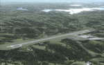
This project adds a new, detailed Branson Airport KBBG (Missouri) to FSX, which opened in May 2009, and is a privately developed commercial airport. The construction of the airport, which involved the flattening of several Ozark Mountains, is claimed to be the largest earthmoving project in Missouri history. As a result, the airport actually sits on a manmade plateau, surrounded by rolling hills. The airport uses the ICAO identifier BBG, however, the airlines use the IATA code BKG. The airport is served by AirTran, Frontier, and ExpressJet (Branson AirExpress), and is located in hilly terrain. Aircraft equipped with a terrain avoidance warning system may experience system activation on final approach. Birds are in the vicinity of the airport. AFCAD with sloping terrain created using Airport Design Editor X v1.47.07, and the hilltops were cleared and flattened and roads were added using SBuilderX 3.13. The terminal, hangar, FBO, and cars were added and modified from stock FSX scenery, using the FSX Object Tool, to resemble as closely as possible the actual airport.
| Filename: | Branson_Airport_KBBGNew_Airport_Scenery_and_Flight.zip |
| License: | Freeware |
| Added: | 5th August 2010, 01:08:33 |
| Downloads: | 2,003 |
| Author: | Carlyle Sharpe |
| Size: | 6.02 MB |
| Category: Flight Simulator X - Scenery | |
| VYMM Mawlamyine Intl Airport V2.0 with Traffic-Pack 2 |
|
File Description:
Mawlamyine International Airport in Burma, Myanmar, include Traffic-Pack 2. Traffic-Pack 1 comes with vyyy4tp1.zip. Traffic-Pack 3 comes soon too. This scenery was produced based of suppositions, stories and voices. It is therefore pure speculation. Whether this airport is ever increased, the God know. If the planned Asean-Highway leads at it past, this airport should gain importance very quickly. Version 2.0 with new docks, jetways, already extended runway, taxiways and new taxisigns. First of all we corrected the airport location to the real one. With Myanmar Air Force area, Helipads and even more parkings for civilian airplanes. You need mai321x.zip, mai738x.zip and mai744x.zip to use with this. Many Thanks go to Harald Nehring and Frank Weiss,
Robert Versluys, Mike Stone and the teams of HOUSE-RP in Burma, FSX Planner, SceneGenX, SBuilder X, Open Ports Scanner, AFXBgDownloader, FSUIPC, Google Earth and AI Flight Planner. This scenery is pure fiction and for FSX only, for FS2004 please download newVYMMfs9.zip and newVYMMup.zip. By HOUSE-RP, Switzerland and Burma
| Filename: | VYMM_Mawlamyine_Intl_Airport_V20_with_TrafficPack_.zip |
| License: | Freeware, limited distribution |
| Added: | 6th June 2008, 15:34:08 |
| Downloads: | 672 |
| Author: | HOUSE-RP, Robby Pauletto |
| Size: | 3.42 MB |
| Category: Flight Simulator X - Scenery | |
| Mesh South America / MeSA E03 |
|
File Description:
FSX Mesh South America Project:
This terrain mesh file is a part of a whole project covering all the Continent
of South America and some islands, divided in tiles identified in a map by its
column (letters) and rows (numbers).
Those files were multi-LOD compiled from 90m SRTM2 source data, reprocessed
with 3DEM to remove voids and spikes, providing a 76.4m (LOD9) horizontal
resolution topography intended for use only in FSX updated with SP1.
Although not well documented, to improve performance, the updated FSX loads DEM
files in threads and only the closer terrain (about 5-10 NM from the point of view)
is rendered in high detail, while at far distances FSX shows up its default low
resolution mesh, when there is not a third part terrain mesh compiled in all
others intermediate level of details (multi-LOD).
THIS FILE:
FSX_MeSA_E03 (Column E x Row 03)
covers the area inside the boundaries:
N = 5º 37,5' N; S = 0º 0' S;
W = 60º 0' W; E = 52º 30' W;
| Filename: | Mesh_South_America__MeSA_E03.zip |
| License: | Freeware |
| Added: | 13th June 2007, 21:41:26 |
| Downloads: | 1,255 |
| Author: | Hely Heck Jr. and José Lôbo |
| Size: | 83.82 MB |
| Category: Flight Simulator X - Scenery | |
| North Victoria v2 for ORBX v2 YBLA Benalla YECH Echuca YYWG Yarrawonga |
|
Images related to this file:
File Description:
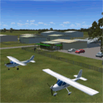
'North Victoria v2' is made to match ORBX Australia v2 scenery. Use 'YBLA Benalla' 'YECH Echuca' 'YYWG Yarrawonga' for ORBX v1 or no ORBX. There are 3 airports YBLA Benalla YECH Echuca YYWG Yarrawonga. ORBX has done these as they have done every airport included with FSX in Australia to a reasonable standard. If I had not already done them for ORBX V1 I would not have bothered. However these are better than ORBX because the surroundings have been modified to match real life. Towns have been added or shifted. Forests cut down or added. There are also custom accurate versions of the actual terminal buildings/hangers. In short a lot more time spent. ORBX had to do every airport has in Australia! Orbx have AI traffic files that cover all 3 airports. These files are for Flight Simulator X. Made using Airport Design Editor using some objects borrowed from Robert Budd's excellent Baccus Marsh and 'Static aircrafts' by Jean-Pierre Fillion. REQUIRED The scenery is designed to interface with ORBX FTX_AU V2 scenery for Australia (payware).
| Filename: | North_Victoria_v2_for_ORBX_v2___YBLA_Benalla_YECH_.zip |
| License: | Freeware |
| Added: | 2nd November 2019, 18:57:53 |
| Downloads: | 325 |
| Author: | Colin Jeffery |
| Size: | 10.01 MB |
© 2001-2026 AVSIM Online
All Rights Reserved
Privacy Policy |