
Where Flight Simulation Enthusiasts Gather from Around the World!
AVSIM Library - Search Results

| Category: Flight Simulator X - Scenery | |
| South America Mesh Scenery, MeshX_A12 |

|
File Description:
Mesh terrain scenery for the whole continental South America, based on SRTM 90m
dem geotiff files (at: ftp://ftp.glcf.umiacs.umd.edu/glcf/SRTM/Degree_Tiles/),
resampled to 76 meter of horizontal resolution (LOD 9). The new files have
improved the vertical resolution from 16m to 10m, resulting in more details
and accuracy over previous versions. There are 50 files, compatible with FS 9
and FS X, identified in a map by column letter and line number, covering the
contiguous countries and states. Boundaries: N = 50º 37.5' S; S = 56º 15' S;
E = 71º 15' W; W = 78º 45' W.
| Filename: | South_America_Mesh_Scenery_MeshX_A12.zip |
| License: | Freeware |
| Added: | 30th October 2006, 05:45:01 |
| Downloads: | 1,955 |
| Author: | Oséas Dourado and José Lôbo |
| Size: | 13.36 MB |
| Category: Flight Simulator X - Scenery | |
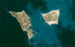
| Whale Island Scenery: "Islands of the Bay of Plenty" |
|
File Description:
This scenery was created from a digital Orthorectified aerial mosaic owned by Environment Bay of Plenty (The Bay of Plenty Regional Council). The imagery has been de-sampled for use in Flight Simulator X and utilizes the default terrain mesh. The textures are intended for summer daylight flying only, although due to the sparse nature of White Islands' Evegetation, the Islands appearance remains relatively consistent throughout the year.
It includes autogen trees, a landable helicopter pad on the top of the Island, Radio masts, and the Department of Conservation (DOC) hut in the south western bay of the island.
| Filename: | Whale_Island_Scenery__Islands_of_the_Bay_of_Plenty.zip |
| License: | Freeware, limited distribution |
| Added: | 9th May 2007, 08:42:59 |
| Downloads: | 1,496 |
| Author: | Tim Barnes |
| Size: | 7.05 MB |
| Category: Flight Simulator X - Scenery | |
| Shahjalal International Airport (Zia) v1.1 |
|
Images related to this file:
File Description:
Updates and Fixed Issues:
**The "VGZR_ADEX_FSX.bgl" is re-edited;
**Some other minor bugs where fixed.
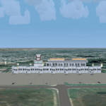
The biggest Shahjalal International Airport (Zia). Meticulously detailed and realistically depicted Flight Simulator X scenery for Shahjalal International Airport (Zia). Created with 3ds max from scratch, the scenery includes accurate buildings, hangars, parking bays, night texturing and illumination effects. The scenery contains variety of static aircraft and animations and photo real terrain texture. This a complete scenery for FSX. The ZIA_Shahjalal International Airport is the busiest airport in Bangladesh and provides access to 4,6 Mio. million passengers a year.
| Filename: | Shahjalal_International_Airport_Zia_v11.zip |
| License: | Freeware |
| Added: | 8th January 2012, 07:38:28 |
| Downloads: | 4,619 |
| Author: | Huseyin Buharali |
| Size: | 14.01 MB |
| Category: Flight Simulator X - Scenery | |
| Alaska Airfields Pack 2 - v1.0 |
|
Images related to this file:
File Description:
This is my second pack of yet another three airfields in Alaska that I have modified to look more like the real thing. The scenery is made of ready made library buildings and trees, no custom made objects, but it's a vast improvement over the stock FSX airfields. The three airfields are (6AK) Rainy Pass Airfield, (8KA) Tatitna Airfield and (5NI) Nikolai Airfield.
PLEASE NOTE: These scenerys are made with FSX Acceleration and Flight 1's Ultimate Alaska X installed. I don't know how they look or work without these add-ons.
| Filename: | Alaska_Airfields_Pack_2__v10.zip |
| License: | Freeware |
| Added: | 19th February 2012, 02:09:32 |
| Downloads: | 2,399 |
| Author: | Torbjorn Kuntze |
| Size: | 1.88 MB |
| Category: Flight Simulator X - Scenery | |
| South America Mesh Scenery, MeshX_D8 |
|
File Description:
Mesh terrain scenery for the whole continental South America, based on SRTM 90m
dem geotiff files (at: ftp://ftp.glcf.umiacs.umd.edu/glcf/SRTM/Degree_Tiles/),
resampled to 76 meter of horizontal resolution (LOD 9). The new files have
improved the vertical resolution from 16m to 10m, resulting in more details
and accuracy over previous versions. There are 50 files, compatible with FS 9
and FS X, identified in a map by column letter and line number, covering the
contiguous countries and states. Boundaries: N = 28º 7.5' S; S = 33º 45' S;
E = 48º 45' W; W = 56º 15' W;
| Filename: | South_America_Mesh_Scenery_MeshX_D8.zip |
| License: | Freeware |
| Added: | 28th October 2006, 15:07:00 |
| Downloads: | 1,921 |
| Author: | Oséas Dourado and José Lôbo |
| Size: | 28.66 MB |
| Category: Flight Simulator X - Scenery | |
| South America Mesh Scenery, MeshX_E3 |
|
File Description:
Mesh terrain scenery for the whole continental South America, based on SRTM 90m
dem geotiff files (at: ftp://ftp.glcf.umiacs.umd.edu/glcf/SRTM/Degree_Tiles/),
resampled to 76 meter of horizontal resolution (LOD 9). The new files have
improved the vertical resolution from 16m to 10m, resulting in more details
and accuracy over previous versions. There are 50 files, compatible with FS 9
and FS X, identified in a map by column letter and line number, covering the
contiguous countries and states. Boundaries: N = 0º 0' S; S = 5º 37.5' S;
E = 41º 15' W; W = 48º 45' W;
| Filename: | South_America_Mesh_Scenery_MeshX_E3.zip |
| License: | Freeware |
| Added: | 28th October 2006, 05:54:49 |
| Downloads: | 1,609 |
| Author: | Oséas Dourado and José Lôbo |
| Size: | 27.48 MB |
| Category: Flight Simulator X - Scenery | |
| KDYT - Sky Harbor Airport - Duluth, MN |
|
File Description:
Here is an improved version of the stock Sky Harbor Airport. I adjusted and added aprons, and taxiways to more closely match real life. I replaced default buildings and added additional buildings. I added more AI parking, static vehicles, aircraft, lightpoles, fences and other filler objects. I added a ramp for amphibious planes and docks for seaplanes. There are both land and water runways here.
This is a really interesting airport, located on a sliver of land in Lake Superior. If you're not using
Ultimate Terrain X the objects going into the water may not be placed correctly.
| Filename: | KDYT__Sky_Harbor_Airport__Duluth_MN.zip |
| License: | Freeware |
| Added: | 20th April 2009, 23:11:20 |
| Downloads: | 1,350 |
| Author: | Jim Cook |
| Size: | 4.72 KB |
| Category: Flight Simulator X - Scenery | |
| Lake Rotorua, NZ photoscenery |
|
File Description:
This is a fully functional, limited feature version of 'Real New Zealand' Rotorua updated for FSX. It differs from the full version in that it doesn't include the accurate, photoreal model of Rotorua Regional Airport, and the aerial ground textures are compressed to a greater degree to reduce the file size.
However it does include 30 x 50 kilometres of aerial photo scenery at 2.5 metres per pixel, and an accurate 'Volcanic Air Safaris' waterfront seaplane base. Those who already own 'Real New Zealand' Rotorua for FS2004 are entitled to a free FSX update via the Windowlight website.
| Filename: | Lake_Rotorua_NZ_photoscenery.zip |
| License: | Check within download |
| Added: | 27th August 2007, 05:28:52 |
| Downloads: | 4,017 |
| Author: | Robin Corn |
| Size: | 46.54 MB |
| Category: Flight Simulator X - Scenery | |
| Helgoland and Airports |
|
Images related to this file:
File Description:
This project rebuilds Germany's Helgoland, upgrades the Duene (EDXH) and Wangerooge (EDWG) airports to be fully AI compliant, and includes AI flight plans between EDXH and EDWG to bring the airports to life. Accurate shorelines, as well as corrected landclass and waterclass, are provided. Updates were created or rebuilt in a manner which carefully aligned airport data with current satellite imagery. Scenery was created using Airport Design Editor X v1.61.5273, SBuilderX 3.13, and the FSX Object Placement Tool. Scenery objects were added and modified from stock FSX scenery to resemble as closely as possible the actual airports.
| Filename: | Helgoland_and_Airports.zip |
| License: | Freeware |
| Added: | 16th June 2014, 06:02:08 |
| Downloads: | 2,825 |
| Author: | Carlyle Sharpe |
| Size: | 1.65 MB |
| Category: Flight Simulator X - Scenery | |
| Daytona_Beach_FL_redone |
|
File Description:
This is a compilation of my changes to scenery at Daytona Beach, FL and the surrounding area during the past year. This includes Updates to KDAB, Daytona International Speedway, KDED, KOMN and KEVB. It also includes the addition of a seaplane dock at Halifax River landing area 1FD1, Main Street pier, City Island ball park, Ponce Inlet lighthouse with a working beacon, inlet jetties, marinas, and landclass corrections. All FBOs are included at airports as well as the Embry Riddle Aeronautical University Flight Center and Tech Center. This scenery has been tested using Ultimate Terrain X and WOAI.
| Filename: | Daytona_Beach_FL_redone.zip |
| License: | Freeware |
| Added: | 4th December 2008, 16:30:47 |
| Downloads: | 3,287 |
| Author: | Art Poole |
| Size: | 2.26 MB |
© 2001-2026 AVSIM Online
All Rights Reserved
Privacy Policy |