
Where Flight Simulation Enthusiasts Gather from Around the World!
AVSIM Library - Search Results

| Category: Flight Simulator X - Scenery | |
| Hungarian VFR Airports - vol 1 |

|
Images related to this file:
File Description:
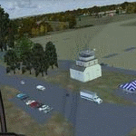
This pack is contains 3 small grass airports of Hungary:
- LHBK - Balatonkeresztur (Only day VFR flight allowed)
- LHPK - Papkutapuszta (Only day VFR flight allowed)
- LHSK - Siofok-Kiliti
These airports, are near the lake Balaton. The Scenerey uses the default FSX object library.
| Filename: | hungarian_vfr_airports_vol1.zip |
| License: | Freeware |
| Added: | 21st November 2012, 17:28:57 |
| Downloads: | 1,922 |
| Author: | Zoltan Meszaros |
| Size: | 5.33 MB |
| Category: Flight Simulator X - Scenery | |
| Hungarian VFR Airports - vol 2 |
|
File Description:
This pack is contains 3 small grass airports of Hungary:
- LHNK - Nagykanizsa (Only VFR flight allowed)
- LHTP - Taploca (Only day VFR flight allowed)
- LHZK - Zalakaros (Only day VFR flight allowed)
The Scenerey uses the default FSX object library.
| Filename: | hungarian_vfr_airports_vol2.zip |
| License: | Freeware |
| Added: | 25th November 2012, 20:57:46 |
| Downloads: | 1,614 |
| Author: | Zoltan Meszaros |
| Size: | 2.81 MB |
| Category: Flight Simulator X - Scenery | |
| Los Roques Archipelago and Airports |
|
Images related to this file:
File Description:
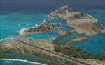
This project rebuilds Venezuela's Los Roques archipelago, adds the Gran Roque (SVRS) and Dos Mosquises (SVDM) airports, and includes AI flight plans, boat traffic, and a custom terrain mesh for Gran Roque. Accurate coastlines and lakes, as well as corrected landclass and waterclass are provided based on the latest available satellite imagery. Although current satellite imagery for this region only exists in relatively low resolution, an abundance of aerial photography was used to add custom features to Gran Roque and Dos Mosquises. Updates were created or rebuilt in a manner which carefully aligned airport data with current satellite imagery, when available. Scenery was created using Airport Design Editor X v1.50.4402, SBuilderX 3.13, and the FSX Object Placement Tool. Scenery objects were added and modified from stock FSX scenery to resemble as closely as possible the actual airports. Thank you to John Hinson and Tiago Besciak for granting permission to adapt their AI flight plans to realistically populate (SVRS) Gran Roque.
| Filename: | los_roques.zip |
| License: | Freeware |
| Added: | 27th July 2013, 02:34:10 |
| Downloads: | 1,362 |
| Author: | Carlyle Sharpe |
| Size: | 7.65 MB |
| Category: Flight Simulator X - Scenery | |
| KCVO / OR52 - Corvallis-Venell Airports |
|
Images related to this file:
File Description:
FSX Scenery - Corvallis Municipal Airport (IATA: CVO, ICAO: KCVO, FAA LID: CVO) is a city owned, public use airport located four nautical miles (5 mi, 7 km) southwest of the central business district of Corvallis, a city in Benton County, Oregon, United States. It is included in the National Plan of Integrated Airport Systems for 2011-2015, which categorized it as a general aviation facility. Venell Airport (FAA LID: OR52) is a private airport located at the southern end of Corvallis Municipal Airport in Benton County, Oregon, USA. For your flying pleasure by John B. Loney, Jr.
| Filename: | corvallis_venell_airports_2015_fsx.zip |
| License: | Freeware, limited distribution |
| Added: | 30th August 2015, 17:49:24 |
| Downloads: | 756 |
| Author: | John B. Loney, Jr. |
| Size: | 22.99 MB |
| Category: Flight Simulator X - Scenery | |
| Cina International Airports: ZBHH Hohhot |
|
File Description:
Airport of Hohhot (ZBHH) in the province of Inner Mongolia, PR China, in its present state, layout based on satellite images and actual charts, buildings made with GMAX.
| Filename: | zbhh_hohhot.zip |
| License: | Freeware, limited distribution |
| Added: | 28th September 2021, 04:00:12 |
| Downloads: | 464 |
| Author: | Winfried Orthmann |
| Size: | 64.47 MB |
| Category: Flight Simulator X - Scenery | |
| Bhutan Airports and Paro Valley |
|
Images related to this file:
File Description:
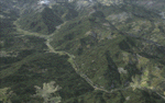
This project adds and updates all of the airports of Bhutan. Bathpalathang (VQBT) and Gelephu (VQGP) are added, Yongphulla (VQ10) is updated and recoded as VQTY, and Paro (VQPR) is fully updated to reflect current satellite imagery. These are all fully functioning AI airports as well. Special attention was given to the entire Paro Valley, and numerous road/river vectors were updated around Gelephu. Accurate coastlines, lakes, road and river data, as well as corrected landclass are provided based on the latest available satellite imagery. They are optimized to fit seamlessly with FTX Vector's roads/water, but they should be fully functional in all FSX configurations.
GA-encoded flight plans for the Buddha Air/Kathmandu charter are provided to enhance service to Paro. NASA SRTM Global 3 arc second terrain mesh is also included for all of Bhutan. Updates were created or rebuilt in a manner which carefully aligned airport data with current satellite imagery, when available. Scenery was created using Airport Design Editor X v1.61.5298, SBuilderX 3.13, and the FSX Object Placement Tool. Scenery objects were added and modified from stock FSX scenery to resemble as closely as possible the actual airports.
| Filename: | bhutan_airports_and_paro_valley.zip |
| License: | Freeware |
| Added: | 19th January 2015, 06:09:17 |
| Downloads: | 11,245 |
| Author: | Carlyle Sharpe |
| Size: | 21.35 MB |
| Category: Flight Simulator X - Scenery | |
| Madagascar Airports (25 in total) |
|
File Description:
This file contains 25 custom-built airports for the island of Madagascar, originally created for the virtual airline Vorona Aviation (http://www.voronaaviation.com) and now available for anyone who wants to enhance Madagascar. Depending on the size of each airport, features include animated parkable hangars, control tower, terminal building, static aircraft, ground vehicles, car parks, fuel farm, fire-station, surrounding trees and shrubs, ships and boats, people, night lighting, perimeter fencing, night textures, heliport and custom AFCAD file for each airport.
| Filename: | madagascar_airports_for_fsx.zip |
| License: | Freeware, limited distribution |
| Added: | 23rd March 2007, 01:16:45 |
| Downloads: | 10,959 |
| Author: | Tim Clayton |
| Size: | 17.36 MB |
| Category: Flight Simulator X - Scenery | |
| Marlborough, NZ - Airports and Photoscenery |
|
File Description:
Real New Zealand Marlborough for FSX was released in 2007, and is now freeware. Includes three airports within the Marlborough area -- Blenheim Regional/Woodbourne, Omaka and Koromiko -- and a large photo scenery area covering much of Marlborough.
| Filename: | realnzmarlfsx.zip |
| License: | Freeware, limited distribution |
| Added: | 17th December 2013, 15:56:01 |
| Downloads: | 3,456 |
| Author: | Robin Corn, Godzone Virtual Flight |
| Size: | 149.93 MB |
| Category: Flight Simulator X - Scenery | |
| Ireland VFR Small Airports Landclass - Update |
|
File Description:
Ireland VFR Small Airports Landclass Files Update.
This scenery update is a set of landclass files for my following airports
EIKN Knock, EISG Sligo, EICM Galway, Connemara and Aran Islands and Ireland VFR Small Airports part 1. The files have been designed for users of the airports with FSX default scenery and hopefully should remove any errant FSX trees from the runway. The scenery has been tested with default scenery only and does not apply to users of photographic scenery.
Simply drop each file into your appropriate Airport scenery folder.
Please enjoy.
| Filename: | ireland_vfr_small_airports_landclass_files_update.zip |
| License: | Freeware |
| Added: | 8th April 2012, 22:41:37 |
| Downloads: | 3,740 |
| Author: | George Keogh |
| Size: | 11 KB |
| Category: Flight Simulator X - Scenery | |
| The Hawaiian Islands - Kauai, Part 1 of 5 |
|
File Description:
The complete scenery package is 446MB in size. In order to accommodate AvSim's file size requirement, this scenery has been broken into five smaller files. However, all five files -- Hawaii-Kauai-RS-01.zip through Hawaii-Kauai-RS-05.zip -- are necessary for this scenery to work properly. My apologies in advance for the added complexity this involves. "Hawaii-Kauai-RS-01" includes a ReadMe with detailed instructions on how to install this scenery.
Kauai itself is the fourth largest of the main Hawaiian Islands. Also known as the "Garden Isle" due to it's lush tropical foliage, it is located about 105 miles (170 kilometers) west of Oahu and just to the east of tiny Niihau. The east side of Mount Wai'ale'ale is considered to be one of the wettest spots on earth receiving an average annual rainfall of 460 inches (1,200 cm). All that water has carved out deep valleys in the central mountains, the most scenic of which is Waimea Canyon, often referred to as "The Grand Canyon of the Pacific". From shoreline cliffs to mountainous heights, to pristine beaches, enjoy exploring this picture postcard perfect landscape.
| Filename: | hawaii-kauai-rs-01.zip |
| License: | Freeware |
| Added: | 13th July 2010, 17:03:20 |
| Downloads: | 6,097 |
| Author: | Rich Sorochak |
| Size: | 88.29 MB |
© 2001-2025 AVSIM Online
All Rights Reserved