
Where Flight Simulation Enthusiasts Gather from Around the World!
AVSIM Library - Search Results

| Category: Flight Simulator X - Scenery | |
| Greece - Chalkidiki Kassandra Photoreal |

|
Images related to this file:
File Description:
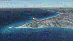
LOD15 photoreal scenery of Kassandra peninsula (a.k.a. first "leg"),part of Chalkidiki peninsula which is one of the greatest Summer destination for locals and foreigners alike.Night textures are also included although without any lighting,however works flawlessly with "Greece Night Environment" by Aerosoft). No airports or airfields or landing strips to land, however you can use float planes to go to the beaches.Nearest airport LGTS Thessaloniki Macedonia INTRNL airport.
The scenery has been designed for, and tested with FSX only. Full installation instructions, settings, hints and tips are included. Please enjoy and I hope you like my scenery as much as I enjoyed building it.
| Filename: | Greece__Chalkidiki_Kassandra_Photoreal.zip |
| License: | Freeware |
| Added: | 1st March 2016, 22:13:47 |
| Downloads: | 971 |
| Author: | Nick Konstantoulas |
| Size: | 150.86 MB |
| Category: Flight Simulator X - Scenery | |
| ENTA - Masjok Airfield - Tana (Finnmark), Norway *v2* |
|
Images related to this file:
File Description:
**This is a second version of the Masjok Airfield. This version fixed the taxiways and location of the airfield. If you have the old scenery, please disable it!** . I made this because i wanted to fly at my nearest airfield. The airfield can operate everything smaller than a Twin Otter. It's in the middle of the region East-Finnmark in Norway, so you can fly to a lot of other airports around the region. Happy flying :D
Check out my Facebook page for repaints!: http://facebook.com/krijagrepaints
Check out my page for other repaint and scenery download's: http://krijagrepaints.wix.com/krijag-repaints
| Filename: | ENTA__Masjok_Airfield__Tana_Finnmark_Norway_v2.zip |
| License: | Freeware |
| Added: | 9th March 2016, 22:44:50 |
| Downloads: | 505 |
| Author: | Kristian Jaegervand |
| Size: | 6.37 KB |
| Category: Flight Simulator X - Scenery | |
| Crete Island, Version 2 |
|
Images related to this file:
File Description:
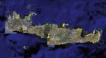
Crete is the bigger than the islands of the Greek archipelago and it is the south rampant of the Aegean sea. This scenery contains the following airports: LGIR, LGSA, LGOB, LGTL and 78 cities.
In this 2nd version I have used the mesh terrain of Yiannis Dermitzakis that offers a bigger realism to the costs. This has put under an obligation to reconstruct the entirety of the populations of the since costs they were located inside the sea. At the same time I have been able to redraw them populations with houses and real facilities that. I believe that I can offer a quite realistic scenery especially in the group of populations of the coast.
| Filename: | Crete_Island_Version_2.zip |
| License: | Freeware |
| Added: | 7th November 2009, 21:08:05 |
| Downloads: | 6,015 |
| Author: | Toni Agramont |
| Size: | 31.14 MB |
| Category: Flight Simulator X - Scenery | |
| BariCity |
|
File Description:
The filmmakers FSX they have not taken into account the city's Italian,
therefore, I decided to make some Italian cities such as the city of Bari.
The scenarios are always built airports, but few are interested in the VFR flight
where the details of the land and the cities are important for the flight.
In the package you will find the file Baricity.bgl that will be placed at the
addon scenery folder and subfolder scenery automatically when FSX scenery you will find it
in the scenario.
In scenery you can fly over the port, the castle and the church of San Nicola.
Good flight at all. We accept criticism and advice. Contact info in Readme.txt file.
| Filename: | BariCity.zip |
| License: | Freeware |
| Added: | 28th June 2015, 00:06:53 |
| Downloads: | 214 |
| Author: | Pasquale Marrulli |
| Size: | 11.21 KB |
| Category: Flight Simulator X - Scenery | |
| KUTS - Huntsville Airport - Texas, USA |
|
Images related to this file:
File Description:
FSX Scenery - Bruce Brothers Huntsville Regional Airport, also known as Huntsville Municipal Airport, (IATA: HTV, ICAO: KUTS, FAA LID: UTS), is a city owned, public use airport located two nautical miles (4 km) northwest of the central business district of Huntsville, a city in Walker County, Texas, United States. It is included in the National Plan of Integrated Airport Systems for 2011-2015, which categorized it as a general aviation facility. Although most U.S. airports use the same three-letter location identifier for the Federal Aviation Administration (FAA) and International Air Transport Association (IATA), this airport is assigned UTS by the FAA and HTV by the IATA. For your flying pleasure by John B. Loney, Jr.
| Filename: | KUTS__Huntsville_Airport__Texas_USA.zip |
| License: | Freeware, limited distribution |
| Added: | 7th September 2015, 22:30:00 |
| Downloads: | 460 |
| Author: | John B. Loney, Jr. |
| Size: | 8.64 MB |
| Category: Flight Simulator X - Scenery | |
| Bari City |
|
File Description:
The filmmakers FSX they have not taken into account the city's Italian,
therefore, I decided to make some Italian cities such as the city of Bari.
The scenarios are always built airports, but few are interested in the VFR flight
where the details of the land and the cities are important for the flight.
In the package you will find the file Baricity.bgl that will be placed at the
addon scenery folder and subfolder scenery automatically when FSX scenery you will find it
in the scenario.
In scenery you can fly over the port, the castle
and the church of San Nicola.
Good flight at all. We accept criticism and advice [email protected]
| Filename: | Bari_City.zip |
| License: | Freeware |
| Added: | 28th June 2015, 23:44:44 |
| Downloads: | 786 |
| Author: | Pasquale Marrulli |
| Size: | 11.21 KB |
| Category: Flight Simulator X - Scenery | |
| KPVG - Hampton Roads Executive Airport - Virginia, USA |
|
Images related to this file:
File Description:
FSX Scenery - Hampton Roads Executive Airport (ICAO: KPVG, FAA LID: PVG) is a public-use airport located seven miles (11 km) southwest of the central business district of Norfolk and northwest of Chesapeake, both independent cities in the U.S. state of Virginia. It is privately owned by Virginia Aviation Associates, L.L.C. Although most U.S. airports use the same three-letter location identifier for the FAA and IATA, Hampton Roads Executive Airport is assigned PVG by the FAA but has no designation from the IATA (which assigned PVG to Pudong International Airport in Shanghai, China). All buildings are custom made. AI traffic contains default aircraft. Created for your flight simming pleasure by John B. Loney, Jr.
| Filename: | KPVG__Hampton_Roads_Executive_Airport__Virginia_US.zip |
| License: | Freeware, limited distribution |
| Added: | 7th September 2014, 23:05:56 |
| Downloads: | 851 |
| Author: | John B. Loney, Jr. |
| Size: | 18.89 MB |
| Category: Flight Simulator X - Scenery | |
| Flagship Scenery: Biggin Hill X |
|
Images related to this file:
File Description:

London Biggin Hill airport is one of the smaller London airports located just south of Bromley.
The airport serves regional flights and caters to more of the VFR operations.
This scenery is our first official Flagship release and is has been through keen eyes before its release.
Scenery features are:
- High definition ground image
- High definition ground detailing
- Illuminated taxiway centre light effect
- Precision placed trees and vehicles
- Fuel trucks hidden inside closed hangars
- High-vis 3D approach lights
- Hold short guards and wigwags
- PAPIs
- Photo realistic Rizon Jet FBO Hangar
- Internally lit hangars
- Many static vehicles and details
- Surrounding Houses
| Filename: | Flagship_Scenery_Biggin_Hill_X.zip |
| License: | Freeware, limited distribution |
| Added: | 15th September 2015, 01:00:41 |
| Downloads: | 4,055 |
| Author: | Mark Piccolo - Soarfly Concepts |
| Size: | 38.47 MB |
| Category: Flight Simulator X - Scenery | |
| Warsaw City X DEMO |
|
Images related to this file:
File Description:
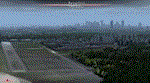
WARSAW CITY X DEMO is a sophisticated scenery package, featuring a detailed scenery of Warsaw city in Poland with surrounding airports, fully compatible with FSX, FSX:SE, P3Dv1, P3Dv2.
This product is a fully functional DEMO version of the commercial payware product. It features same layouts as in the full version but with limited 3D objects and low resolution textures. Using this free demo ensures no problems with online (VATSIM, IVAO, multiplayer etc.) flying in case some users use the payware scenery and some don't.
Warsaw is the capital and the largest city of Poland located on the Vistula (Wisla) River. Warsaw City 2015 gives you a possibility to fly over an extremely large area of Warsaw city. We have included a photoreal ground textures of about 5200 square km. The city centre has hundreds of custom buildings modeled, there are all VFR-important landmarks on the whole included area too. We have also created 13 variously detailed airports and heliports for the project: Modlin EPMO, Babice EPBC, Chrcynno/Nasielsk, Sobienie EPSJ, Goraszka EPGO, Konstancin-Jeziorna, Konstancin Heliport, Reczaje (lite), Kroczewo (lite), Trebki Nowe (lite), Wincentow 1 (lite), Wincentow 2 (lite), Zabia Wola (lite).
The product is equipped with an automatic installer, which means that the scenery will be automatically added to the Flight Simulator Scenery Library. Please uninstall all previous versions of similar sceneries you may have installed before. Please make also sure that no duplicated AFCAD files are installed.
Enjoy your virtual flying with Drzewiecki Design!
| Filename: | Warsaw_City_X_DEMO.zip |
| License: | Commercial demo |
| Added: | 5th September 2015, 01:09:15 |
| Downloads: | 3,352 |
| Author: | Drzewiecki Design |
| Size: | 36.95 MB |
| Category: Flight Simulator X - Scenery | |
| Honduras Islands v3 |
|
Images related to this file:
File Description:
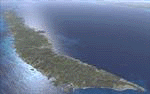
Version 3 includes all previous patches and updates. This version also restructures the file system to be fully compatible with the ORBX "FTX Global openLC North America" product as well as adding functionality for default FSX users. Additionally, water class scenery is updated to appear more realistic, MHRO is updated to reflect the newly expanded apron, and SRTMGL1 (30m) mesh is included. All landclass polygons and coastlines were meticulously hand-drawn directly from satellite imagery to provide the most detailed and accurate scenery available for this region.
This project rebuilds the islands of Roatán, Barbareta, Guanaja, and Utila, and adds Cayos Cochinos and the numerous cays associated with the "Islas de la Bahia" (Islands of the Bay). Roatán (MHRO), Guanaja (GJAJ/MHNJ) and Puerto Lempira (MHPL) are completely overhauled and positioning is corrected. New and fully functioning AI airports are added for Utila (MHUT), Fort Cay (MHFC) and Cochino Pequeño (MHCP) of the Cayos Cochinos chain, and La Ceiba (MHLC) is modified to accommodate more AI traffic. Accurate coastlines, lakes, road and river data, as well as corrected landclass are provided based on the latest available satellite imagery. GA flight plans are provided to add or enhance service to the smaller islands. Updates were created or rebuilt in a manner which carefully aligned airport data with current satellite imagery, when available. Scenery was created using Airport Design Editor X v1.70.6042, SBuilderX 3.13, and the FSX Object Placement Tool. Scenery objects were added and modified from stock FSX scenery to resemble as closely as possible the actual airports.
| Filename: | Honduras_Islands_v3.zip |
| License: | Freeware |
| Added: | 23rd December 2016, 08:17:26 |
| Downloads: | 1,614 |
| Author: | Carlyle Sharpe |
| Size: | 17.35 MB |


© 2001-2026 AVSIM Online
All Rights Reserved
Privacy Policy |