
Where Flight Simulation Enthusiasts Gather from Around the World!
AVSIM Library - Search Results

| Category: Flight Simulator X - Scenery | |
| The Thames Barrier - England |

|
Images related to this file:
File Description:

This scenery adds the Thames Barrier to Orbx EU England Regional scenery package. Compatible with both FSX & P3D. The Thames Barrier is the world's second-largest movable flood barrier (after the Oosterscheldekering in the Netherlands) and is located downstream of central London, United Kingdom. Its purpose is to prevent London from being flooded by exceptionally high tides and storm surges moving up from the sea. It needs to be raised (closed) only during high tide; at ebb tide it can be lowered to release the water that backs up behind it. Not tested with default FSX or any other setup. You must have Orbx EU England regional scenery to use the compiled scenery files as intended. By Bryan Wallis aka fltsimguy.
| Filename: | The_Thames_Barrier__England.zip |
| License: | Freeware, limited distribution |
| Added: | 27th January 2013, 01:08:30 |
| Downloads: | 1,340 |
| Author: | Bryan Wallis |
| Size: | 584.23 KB |
| Category: Flight Simulator X - Scenery | |
| The French Polynesia Tuamotu Archipelago Scenery X Part A (Tuamotu-X_A) |
|
File Description:
FSX Scenery FRENCH POLYNESIA TUAMOTU ARCHIPELAGO SCENERY Part A
This scenery improves specific area (Tuamotu Archipelago) of FSX.
The archiperago scattered in the northeast of Tahiti island is composed of 78 islands.
I reproduced the 52 islands in the archipelago as add-on senery.
They are islands like a beautiful necklace sprinkled in the tropical ocean.
The French Polynesia Tuamotu Archipelago Scenery X Part A (Tuamotu-X_A)
includes west side of the whole archipelago because of the file size.
This scenery requires Tuamotu-X_B scenery (fpta-xb.zip).
Please be sure to download the Tuamotu-X_B.
When the Tuamotu-X_B scenery is installed together with this scenery,
the huge Tuamotu Archipelago including all of "The Chain Islands" will appear.
By Kazuo Kawamura
| Filename: | The_French_Polynesia_Tuamotu_Archipelago_Scenery_X.zip |
| License: | Freeware, limited distribution |
| Added: | 27th February 2010, 07:36:22 |
| Downloads: | 11,014 |
| Author: | Kazuo Kawamura |
| Size: | 81.3 MB |
| Category: Flight Simulator X - Scenery | |
| The French Polynesia Tuamotu Archipelago Scenery X Part B (Tuamotu-X_B) |
|
File Description:
FSX Scenery FRENCH POLYNESIA TUAMOTU ARCHIPELAGO SCENERY Part B
This scenery improves specific area (Tuamotu Archipelago) of FSX.
The archiperago scattered in the northeast of Tahiti island is composed of 78 islands.
I reproduced the 52 islands in the archipelago as add-on senery.
They are islands like a beautiful necklace sprinkled in the tropical ocean.
The French Polynesia Tuamotu Archipelago Scenery X Part B (Tuamotu-X_B)
includes east side of the whole archipelago because of the file size.
This scenery requires Tuamotu-X_A scenery (fpta-xa.zip).
Please be sure to download the Tuamotu-X_A.
When the Tuamotu-X_A scenery is installed together with this scenery,
the huge Tuamotu Archipelago including all of "The Chain Islands" will appear.
By Kazuo Kawamura
| Filename: | The_French_Polynesia_Tuamotu_Archipelago_Scenery_X.zip |
| License: | Freeware, limited distribution |
| Added: | 27th February 2010, 07:38:01 |
| Downloads: | 11,019 |
| Author: | Kazuo Kawamura |
| Size: | 78.1 MB |
| Category: Flight Simulator X - Scenery | |
| 2 Fronson Hangars |
|
Images related to this file:
File Description:
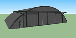
This model was created to be placed in FSX as airport scenery using Airport Design Editor.
I created it for my own use when i was re-creating RNAS HMS Nuthatch which was a Naval Airstation near Anthorn on the Solway Coast in Cumberland (now Cumbria), United Kingdom.
History of RNAS HMS Nuthatch...
Work began on building an airfield at Anthorn for the Fleet Air Arm in late 1943, with Royal Naval Air Station Anthorn, or HMS Nuthatch opening on 7 September 1944, with three tarmac runways.
It was the base of No. 1 Aircraft Receipt and Despatch Unit (No. 1 ARDU), which had the job of receiving aircraft fresh from manufacturers, modifying them to Service standards and despatching them to operational squadrons, with the unit specialising in the Vought F4U Corsair.
No. 1 ARDU continued to operate from Anthorn following the end of the Second World War, while a number of Fleet Air Arm Squadrons were also based at the airfield in the immediate post war years.
The airbase shut down in March 1958.
The Airfield is now the site of a VLF/LF transmitter used for transmitting orders to Submarines, it is also home to three atomic clocks for transmitting Britains time signal transmissions.
None of the Hangars (11 Pentad and 22 Fromson) survive at the site but their concrete standings are still visable.
Depicted here are representations of the Fromson type hangers created from dimensions in a 1947 survey.
I created the model using Google Sketchup and converted it for use in FSX using Model ConverterX.
This is my 1st attempt at scenery creation and is therefore pretty basic.
There are no known issues and it works fine in FSX.
| Filename: | 2_Fronson_Hangars.zip |
| License: | Freeware |
| Added: | 8th June 2014, 07:13:54 |
| Downloads: | 251 |
| Author: | Mark John Byers |
| Size: | 1.4 MB |
| Category: Flight Simulator X - Scenery | |
| LGTS X 2014 - Thessaloniki Makedonia Airport |
|
Images related to this file:
File Description:

Eight years after the first scene the group of Greek airports Project invites you to travel in Thessaloniki which marked the route of the group in the area of Flight Simulator. The scene following the design of our philosophy which allows the simmer to enjoy a full scene without getting tired to find solutions which have to do with settings, yields etc, without unnecessary construction that nobody ever sees and which only need to create a commercial impression in some photos. Objects reconstructed with Gmax and 3dmax that make you enjoy your virtual trip to the airport, and not only because this time we have also included many points from the beautiful city of Thessaloniki as for example the known White Tower, the Aristotelous Square, the facilities of the Thessaloniki International Fair, the football stadiums of the best known groups, the opera house, the City Hall, and many others in a separate scenery (THESSALONIKI_VFR ) included in this version which you are not obliged to install but in our opinion will give you a different sensation in your approach to Macedonia airport. The THESSALONIKI_VFR also combined with the very good photoreal from Antonis Gikas state of GAP "Hellenic Actual Scenery" and with any other photoreal is circulated to the region. This photoreal version is currently for FS9 but very soon will follow and the version for FSX, P3DV1/P3DV2. Retained many of the features of the previous version as the transparent windows which give different feel on the inside part of the terminal, and replaced with different modern way. Of course for the FSX version corrected all non-compliant issues from FS9 - FSX. Enjoy free your flight for the magnificent Thessaloniki, in Greece, in Macedonia.
| Filename: | LGTS_X_2014__Thessaloniki_Makedonia_Airport.zip |
| License: | Freeware |
| Added: | 20th March 2014, 20:12:03 |
| Downloads: | 14,021 |
| Author: | GREEK AIRPORTS PROJECT - Team Chief: Michalis Triantafillou |
| Size: | 91.25 MB |
| Category: Flight Simulator X - Scenery | |
| KAVL - Asheville Regional Airport 2015 - North Carolina, USA |
|
Images related to this file:
File Description:
This is the new KAVL while they remodel the Airport.
Runway 34-16 has been closed for upgrade and a temporary runway 35-17 has been opened in the meantime.
Photoreal textures for day night and snow are included.
| Filename: | KAVL__Asheville_Regional_Airport_2015__North_Carol.zip |
| License: | Check within download |
| Added: | 21st December 2015, 09:45:53 |
| Downloads: | 1,252 |
| Author: | Daniel Goldsmith |
| Size: | 31 MB |
| Category: Flight Simulator X - Scenery | |
| St. Helena, Ascension, and Tristan da Cunha Islands |
|
Images related to this file:
File Description:
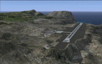
This project was begun to add the new airport (FHSH) to St. Helena Island and eventually was expanded to include a complete remake of Ascension Island (FHAW) and Tristan da Cunha (with an optional airport FHTC) and Gough Island with the actual weather station heliport (FHGH). Tested in both the default FSX/Acceleration and with FTX Global/Vector, accurate coastlines, lakes, road data, and SRTMGL1 (30m) mesh, as well as corrected landclass are provided based on the latest available satellite imagery. Flight plans are provided for the proposed commercial service to St. Helena, and some additional GA and military flights to the island are added as well.
The FSX St. Helena (FHSH) airport was created by aligning master plans for the airport with current satellite data and by studying many of the pictures that have been posted as the airport has taken shape. The official opening of the real airport on May 21, 2016, has been pushed back for more field tests due to challenging crosswinds. The Ascension Island (FHAW) airport was updated after I realized that Ascension could receive commercial service as a result of the new St. Helena airport. The entire airfield is redesigned to allow the volcanic terrain to display properly. The airbase, towns, BBC Atlantic relay station, and numerous satellite dishes, radomes, and wind turbines now appear in their real-world locations. Since I was already in the region, I added the Tristan da Cunha Islands (including Inaccessible, Nightingale and Gough Islands) and the Gough Island weather station maintained by the South African National Antarctic Programme. I also added an optional airport (and flight plans) to Tristan da Cunha (FHTC), which can be easily enabled/disabled. The FHTC airport is placed on the only part of the island that appears to be free of people or farmland, and the area is just long enough to accommodate a pared-down version of the St. Helena airport.
Updates were created or rebuilt in a manner which carefully aligns airport data with current satellite imagery. Scenery was created using Airport Design Editor X v1.67.5684, SBuilderX 3.13, and the FSX Object Placement Tool. Scenery objects were added and modified from stock FSX scenery to resemble as closely as possible the actual airports. The animated flag model is by Dietmar Loleit, the FSX apron lights included are from the set created by Jim Dhaenens, and the animated wind turbines and radomes are from the freeware package by Ray Porter.
| Filename: | St_Helena_Ascension_and_Tristan_da_Cunha_Islands.zip |
| License: | Freeware |
| Added: | 1st May 2016, 11:23:05 |
| Downloads: | 6,086 |
| Author: | Carlyle Sharpe |
| Size: | 10.52 MB |
| Category: Flight Simulator X - Scenery | |
| Matekane Airfield V2 (FXME) Part 2 [Fixed] |
|
Images related to this file:
File Description:
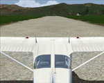
This file fixes an error in Maledives (VRMM). Please delete the file Matekane Airfield V2 (FXME) Part 2 and download the file Matekane Airfield V2 (FXME) Part 2 fix.
Matekane airfield is a very small airfield and is located in South Africa in Lesotho. You could to say a dangerous airfield- This Scenery is designed for FSX Sp2/Acc + DX10. This Scenery has Grass animation, animals and sounds. An video can find by youtube: /watch?v=9K4fOxgMfYk Have Fun =)
| Filename: | Matekane_Airfield_V2_FXME_Part_2_Fixed.zip |
| License: | Freeware |
| Added: | 20th January 2012, 00:49:14 |
| Downloads: | 2,360 |
| Author: | Ulukan Zafer |
| Size: | 126.37 MB |
| Category: Flight Simulator X - Scenery | |
| Rio Vista Municipal Airport 2015 |
|
Images related to this file:
File Description:
FSX Scenery-Rio Vista Municipal Airport (FAA LID: O88) is a public airport located three miles (4.8 km) northwest of Rio Vista, serving Solano County, California, USA. This general aviation airport covers 273 acres (110 ha) and has two runways and one helipad. The airport is the current base of operations for the Travis AFB Aero Club. It opened in 1993, replacing the original Rio Vista Airport which closed in 1995. By John B. Loney, Jr.
| Filename: | Rio_Vista_Municipal_Airport_2015.zip |
| License: | Freeware, limited distribution |
| Added: | 18th May 2015, 12:53:28 |
| Downloads: | 239 |
| Author: | John B. Loney, Jr. |
| Size: | 6.43 MB |
| Category: Flight Simulator X - Scenery | |
| Isola San Giulio |
|
File Description:
This scenario a small Italy island of San Giulio on Lake Orta, near the famous Lake Maggiore its coordinates are N45.47.70 E8.23.86.
For the best information you can search Google Isola San Giulio.
In the package you will find the file Isola_San_Giulio.bgl that will be placed at the addon scenery folder and subfolder scenery automatically when FSX scenery you will find it in the scenario.
Good flight at all. We accept criticism and advice [email protected]
| Filename: | Isola_San_Giulio.zip |
| License: | Freeware |
| Added: | 3rd July 2015, 16:49:13 |
| Downloads: | 626 |
| Author: | Pasquale Marrulli |
| Size: | 35.02 KB |


© 2001-2026 AVSIM Online
All Rights Reserved
Privacy Policy |