
Where Flight Simulation Enthusiasts Gather from Around the World!
AVSIM Library - Search Results

| Category: Flight Simulator X - Scenery | |
| Florida Keys Airports |

|
Images related to this file:
File Description:
FSX Scenery - Florida Keys Airports. This package contains seven (7) airports located in the Florida Keys. There are four (4) land based airports, most of which are private strips and three (3) are seaplane bases. Scenery includes photo-real ground and AI floatplane operations. AI floatplanes are also included. For your flight simming pleasure by John B. Loney, Jr.
| Filename: | Florida_Keys_Airports.zip |
| License: | Freeware, limited distribution |
| Added: | 13th December 2015, 19:55:50 |
| Downloads: | 1,246 |
| Author: | John B. Loney, Jr. |
| Size: | 16.85 MB |
| Category: Flight Simulator X - Scenery | |
| GCFV, GCLA , GCLP, GCRR, GCTS, GCXO - Canary Islands, Spain |
|
File Description:
This is a puristic, frame rate friendly scenery.
GCFV Fuerteventura, GCLA La Palma, GCLP Gran Canaria, GCRR Lanzarote, GCTS Tenerife South and GCXO Tenerife North are included.
Terminals have gate signs to show the number of the gate and ground painted taxiway signs for better orientation. Tested with FSX and P3D V2.5. Taxiways as per January 2015.
| Filename: | GCFV_GCLA__GCLP_GCRR_GCTS_GCXO__Canary_Islands_Spa.zip |
| License: | Freeware, limited distribution |
| Added: | 17th May 2015, 11:16:32 |
| Downloads: | 12,550 |
| Author: | Stefan Liebe |
| Size: | 1.6 MB |
| Category: Flight Simulator X - Scenery | |
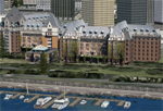
| Bembridge X-HD |
|
Images related to this file:
File Description:

Bembridge is one of only two airports on the Isle of Wight, it is small but a very picturesque area. This scenery is provided with photo real surround to give you a smoother transition from HD to default scenery.
The airport offers pleasure flights for a small fee and of course a flight school operates at the airport.
This scenery is perfect for anyone with a love of GA flying, the surrounding photo scenery allows for VFR operations and the airport is accurately placed in the virtual world.Feature include:
High definition ground image.
High definition ground detailing.
Filler objects from "SFC Airfield Objects".
Precision placed trees and vehicles.
Fuel trucks hidden inside closed hangars.
Real water in the pond.
Hold short guards.
Many static vehicles and details.
Accurate BN Aviation hangars.
Very low frame impact.
| Filename: | Bembridge_XHD.zip |
| License: | Freeware, limited distribution |
| Added: | 8th January 2017, 23:55:14 |
| Downloads: | 1,565 |
| Author: | Mark Piccolo - Soarfly Concepts |
| Size: | 30.34 MB |
| Category: Flight Simulator X - Scenery | |
| Silkeborg airfield EKCR |
|
Images related to this file:
File Description:
A photoreal scenery with an smaller airfield EKCR, and has a grass runway 1050x30 m. The airfield are laying in the middle part of
Jutland about 10 km southwest of the city
Silkeborg in Denmark
By Otto Knudsen.
| Filename: | Silkeborg_airfield_EKCR.zip |
| License: | Freeware |
| Added: | 23rd August 2018, 00:12:41 |
| Downloads: | 366 |
| Author: | Otto Knudsen |
| Size: | 33.83 MB |
| Category: Flight Simulator X - Scenery | |
| Victoria, Canada including US Southern Gulf Islands and San Juan Islands - Part 1 of 2 |
|
Images related to this file:
File Description:
FSX-only version of Victoria, Canada area scenery including the Southern Gulf Islands and the San Juan Islands of the US. Includes automated installer and configurator by Scot Fraser.
Features:
-accurate shorelines, lakes and streams;
-landclass;
-FSX multi-LOD mesh with 10m maximum resolution;
-complete road network with moving traffic;
-railroads;
-utility corridors;
-marinas and ferry terminals;
-many static boats, including a custom model of the Canada Coast Guard ship Sir Wilfred Laurier;
-detailed models of major buildings and the Ogden Point Terminal;
-many bridges;
-nearly 300 marine lights; and corrected antennae locations.
Facilities include Don Grovestine's famous CYYJ (Victoria International Airport); 12 other Canadian land-based airports: Butler Field, Duncan (CAM3), Gaines, Hastings, Hudson Island, James Island, Thomas, Village Bay, Raven Field (CML2), Saltspring, Sidney Island, Whiskey Point; 20 US airports Blakely (38WA), Burden (61WA), Center Island (79WA), Clam Harbor (WA35), Crane Island, Decatur Shores (WN07), Decatur-Jones (WA18), Waldronaire (90WA), Orcas Island (KORS), Friday Harbour (KFHR), Lopez Island (S31), Pile Point, Roche Harbor (WA09), Shaw Island, Stuart Island Airpark (7WA5), Stuart Island West (2WA3), Wilding (6WA5), Windsock (4WA4); 12 floatplane facilities: Bedwell (CAB3), Fisherman's Bay (WA81), Friday Harbor (W33), Ganges (CAX6), Maple Bay, Mayne (CAW7), Port Washington (CAP8), Roche Harbor (W39), Rosario (W49), Shawnigan Lake (CAV8), Victoria Harbour (CYWH), Victoria International (CAP5) and Westsound, Orcas (WA83) - many with AI traffic; 9 heliports: Ganges (CAL7), Mayne (CBF5), Camel Point (CBF7), Jubilee (CBK8), Victoria General (CBW7) Madrona Bay (CBW9), Shoal Point (CBZ7), Mount Belcher (CMBH).
AI models include the DHC-2 floatplane in local liveries, a cruise ship model (by Mitsuya Hamaguchi) and two repaints, pilot boat, and small boats (by Larry Silsbee).
Ultimate Terrain X compatible (not required). Users of Vancouver+ for FSX will also get additional cruise ship traffic and additional floatplane and helicopter traffic. Full documentation. By Don Grovestine, Jon Patch and Holger Sandmann. Many other contributors: see documentation. Part 1 of 2 - you also need file vicenh7b.zip
| Filename: | Victoria_Canada_including_US_Southern_Gulf_Islands.zip |
| License: | Check within download |
| Added: | 29th January 2010, 21:23:17 |
| Downloads: | 23,155 |
| Author: | Don Grovestine, Jon Patch and Holger Sandmann |
| Size: | 56.8 MB |
| Category: Flight Simulator X - Scenery | |
| Victoria, Canada including US Southern Gulf Islands and San Juan Islands - Part 2 of 2 |
|
Images related to this file:
File Description:

FSX-only version of Victoria, Canada area scenery including the Southern Gulf Islands and the San Juan Islands of the US. Includes automated installer and configurator by Scot Fraser.
Features:
-accurate shorelines, lakes and streams;
-landclass;
-FSX multi-LOD mesh with 10m maximum resolution;
-complete road network with moving traffic;
-railroads;
-utility corridors;
-marinas and ferry terminals;
-many static boats, including a custom model of the Canada Coast Guard ship Sir Wilfred Laurier;
-detailed models of major buildings and the Ogden Point Terminal;
-many bridges;
-nearly 300 marine lights; and corrected antennae locations.
Facilities include Don Grovestine's famous CYYJ (Victoria International Airport); 12 other Canadian land-based airports: Butler Field, Duncan (CAM3), Gaines, Hastings, Hudson Island, James Island, Thomas, Village Bay, Raven Field (CML2), Saltspring, Sidney Island, Whiskey Point; 20 US airports Blakely (38WA), Burden (61WA), Center Island (79WA), Clam Harbor (WA35), Crane Island, Decatur Shores (WN07), Decatur-Jones (WA18), Waldronaire (90WA), Orcas Island (KORS), Friday Harbour (KFHR), Lopez Island (S31), Pile Point, Roche Harbor (WA09), Shaw Island, Stuart Island Airpark (7WA5), Stuart Island West (2WA3), Wilding (6WA5), Windsock (4WA4); 12 floatplane facilities: Bedwell (CAB3), Fisherman's Bay (WA81), Friday Harbor (W33), Ganges (CAX6), Maple Bay, Mayne (CAW7), Port Washington (CAP8), Roche Harbor (W39), Rosario (W49), Shawnigan Lake (CAV8), Victoria Harbour (CYWH), Victoria International (CAP5) and Westsound, Orcas (WA83) - many with AI traffic; 9 heliports: Ganges (CAL7), Mayne (CBF5), Camel Point (CBF7), Jubilee (CBK8), Victoria General (CBW7) Madrona Bay (CBW9), Shoal Point (CBZ7), Mount Belcher (CMBH).
AI models include the DHC-2 floatplane in local liveries, a cruise ship model (by Mitsuya Hamaguchi) and two repaints, pilot boat, and small boats (by Larry Silsbee).
Ultimate Terrain X compatible (not required). Users of Vancouver+ for FSX will also get additional cruise ship traffic and additional floatplane and helicopter traffic. Full documentation. By Don Grovestine, Jon Patch and Holger Sandmann. Many other contributors: see documentation. Part 2 of 2 - you also need file vicenh7a.zip
| Filename: | Victoria_Canada_including_US_Southern_Gulf_Islands.zip |
| License: | Check within download |
| Added: | 29th January 2010, 21:21:49 |
| Downloads: | 23,159 |
| Author: | Don Grovestine, Jon Patch and Holger Sandmann |
| Size: | 59.08 MB |
| Category: Flight Simulator X - Scenery | |
| Teterboro Airport, New Jersey |
|
File Description:
Teterboro Airport is located across the Hudson River in New Jersey, just 12 miles from midtown Manhattan, Teterboro Airport is considered a general aviation reliever airport. As a reliever airport, it does not offer scheduled airline service, nor does it permit operations of any aircraft in excess of 100,000 pounds on any airport surface. Teterboro Airport has five Fixed Base Operators (FBOs), Atlantic Aviation, Jet Aviation, First Aviation, Meridian, and Signature Aviation. Scenery includes Phototexture to cover the unattractive stock FSX airport ground texture. Along with Night, Fall and Winter varience textures. Autogen is placed on top of phototexture in specific areas. ALL airport objects have been placed in proper position to photoscenery. Aprons and taxiways in alignment with photostexture. Supports AI traffic for the pilots who use. Numerous Airport vehicles and stacic aircraft on the gounds. There are a few GMAX scenery objects along with Stock FSX objects. If you have cast ground shadows checked in your display feature, some of the vegetation will show black blocks on its base, so uncheck this if you wish. I designed this for all the Charter and General Aviation pilots out there, including myself.
| Filename: | Teterboro_Airport_New_Jersey.zip |
| License: | Freeware |
| Added: | 7th July 2010, 00:47:37 |
| Downloads: | 1,784 |
| Author: | Eric McCloud |
| Size: | 36.84 MB |
| Category: Flight Simulator X - Scenery | |
| Dalmatia coastline revamp |
|
File Description:
Detailed coastline for the southern part of the Dalmatia region of the Adriatic sea. This means islands actually look like islands and not a mess of rectangles. The improved area spans around 4300 km2, though a lot of it is water.
| Filename: | Dalmatia_coastline_revamp.zip |
| License: | Freeware |
| Added: | 11th December 2014, 12:45:23 |
| Downloads: | 271 |
| Author: | Timotej Zuntar |
| Size: | 109.14 KB |
| Category: Flight Simulator X - Scenery | |
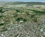
| Sardinia Photoreal 13/14 - Gulf of Cagliari (1/2) |
|
Images related to this file:
File Description:

Cagliari is the capital of the Island of Sardinia, located in the south part of the island.
Coverage Gulf of Cagliari and the metropolitan area of Cagliari, including LIEE Airport (Elmas).
Credits: Aerial photos summer 2012 courtesy of Microsoft Virtual Earth.
| Filename: | Sardinia_Photoreal_1314__Gulf_of_Cagliari_12.zip |
| License: | Freeware |
| Added: | 19th June 2013, 11:51:52 |
| Downloads: | 4,091 |
| Author: | Diego PAPARELLA |
| Size: | 443.25 MB |
| Category: Flight Simulator X - Scenery | |
| Sardinia Photoreal 11/14 - Campidano (2/2) |
|
Images related to this file:
File Description:
Coverage Campidano area in western/central part of Sardinia (Italy), includes Gulf of Oristano, LIER Airport (Oristano - Fenosu), Bosa, Is Arutas beach, Abbasanta, and Capo Frasca (AWTI - Air Weapons Training Installation).
Credits: Aerial photos summer 2012 courtesy of Microsoft Virtual Earth.
| Filename: | Sardinia_Photoreal_1114__Campidano_22.zip |
| License: | Freeware |
| Added: | 18th June 2013, 08:04:57 |
| Downloads: | 2,903 |
| Author: | Diego PAPARELLA |
| Size: | 407.77 MB |
© 2001-2026 AVSIM Online
All Rights Reserved
Privacy Policy |