
Where Flight Simulation Enthusiasts Gather from Around the World!
AVSIM Library - Search Results

| Category: Flight Simulator X - Scenery | |
| KSAN - San Diego International Airport, San Diego (CA), Photo Real Scenery |

|
Images related to this file:
File Description:

This Photo Real scenery is a complete rebuild for the FSX Default KSAN airport using the latest version of ADE & SBuilderX scenery design tool.
SAN is one of my favorite airports to fly into because of its beautiful scenery, and it is ranked as #10 on the World'����s Most Dangerous Airports list. This scenery includes the new expansion of Terminal 2 that is scheduled to be completed in 2013, but the gates and ground textures are not update yet. I will do a scenery update as soon as those files are available. It also includes new terminal buildings, new buildings located on the RWY 27 approach, and Photo Real ground textures that gives the airport a more realistic feeling. I have added some Google Earth buildings, new warehouses, and several nice scenery enhancements. The runways and airport aprons are aligned to match Google & Yahoo satellite imagery. I hope you enjoy the scenery.
| Filename: | KSAN__San_Diego_International_Airport_San_Diego_CA.zip |
| License: | Freeware |
| Added: | 29th October 2011, 02:07:18 |
| Downloads: | 11,005 |
| Author: | Glenn Johnson |
| Size: | 33.37 MB |
| Category: Flight Simulator X - Scenery | |
| EGLL - Heathrow Airport - London, United Kingdom |
|
File Description:
Taxiways, terminal and parking state July 2015th. Terminals 1 - 5 have gate signs to show the number of the gate and ground painted taxiway signs for better orientation. Tested with FSX and P3D V2.5
| Filename: | EGLL__Heathrow_Airport___London_United_Kingdom.zip |
| License: | Freeware, limited distribution |
| Added: | 13th July 2015, 15:27:39 |
| Downloads: | 8,781 |
| Author: | Stefan Liebe |
| Size: | 3.41 MB |
| Category: Flight Simulator X - Scenery | |
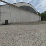
| YBSS Bacchus Marsh AU |
|
Images related to this file:
File Description:
Bacchus Marsh Airfield is located approx 40km WNW of Melbourne, Victoria, Australia. It was never included in the original FSX.
This package incorporates a choice of blending into either the fsx default landscape or the Orbx AU landscape. This airport has been modeled from photographs freely available off the internet.
A folder is enclosed to give comparisons of detail at ground level. In Display Settings, set texture resolution as desired.
All hangars are my generic ones and chosen for similarity in shape, colour and size to the real ones on the ground. The package includes about 100 FSDS custom made scenery objects ranging from hangars to ground litter and many in
between, useful for also installing in other rural airports via a scenery editor. It includes some grass and tussocks vegetation to help give the visual of a rural airfield.
| Filename: | YBSS_Bacchus_Marsh_AU.zip |
| License: | Freeware |
| Added: | 10th September 2016, 03:26:23 |
| Downloads: | 727 |
| Author: | Robert Budd |
| Size: | 9.36 MB |
| Category: Flight Simulator X - Scenery | |
| FABE - Bisho Airport, South Africa - Version 2 |
|
Images related to this file:
File Description:
Bhisho is the Xhosa word for buffalo, which is also the name of the river that runs through this town. The town is part of the Buffalo City Metropolitan Municipality of the Eastern Cape, the urban agglomeration around East London. This is a standalone full version. Made from Custom models and textures for FSX.
| Filename: | FABE__Bisho_Airport_South_Africa__Version_2.zip |
| License: | Freeware |
| Added: | 9th October 2013, 21:01:16 |
| Downloads: | 1,006 |
| Author: | Jacques Botha |
| Size: | 2.74 MB |
| Category: Flight Simulator X - Scenery | |
| LFOX Etampes Mondesir |
|
File Description:
Scenery LFOX Etampes Mondesir V1.0 for FSX
Tested with SP2 Acceleration + UTX Europe.
V1.0: Initial version
This file modifies the airfield Etampes Mondesir in FSX. It was made with ADE (Airport Design Editor), SbuilderX and Whisplacer.
Thank you to the respective authors and Patrick Renaudin for its objects.
Etampes is a French commune located at forty-nine kilometers southwest of Paris, sub-prefecture of the department of Essonne, in the Ile-de-France.
| Filename: | LFOX_Etampes_Mondesir.zip |
| License: | Freeware |
| Added: | 26th May 2010, 03:32:36 |
| Downloads: | 2,427 |
| Author: | Stephane Gouzon |
| Size: | 12.65 MB |
| Category: Flight Simulator X - Scenery | |
| LFCH - La Teste De Buch, France |
|
Images related to this file:
File Description:

Scenery LFCH La Teste De Buch V1.0 for FSX; Tested with SP2 Acceleration + UTX Europe. V1.0: Initial version
This file modifies the airfield La Teste De Buch in FSX. It was made with ADE (Airport Design Editor), SbuilderX and Whisplacer. Thank you to the respective authors and Patrick Renaudin for their objects.
La Teste de Buch is a commune in the Landes department in Aquitaine in south-western France.
| Filename: | LFCH__La_Teste_De_Buch_France.zip |
| License: | Freeware |
| Added: | 29th May 2010, 09:04:12 |
| Downloads: | 3,031 |
| Author: | Stephane Gouzon |
| Size: | 9.43 MB |
| Category: Flight Simulator X - Scenery | |
| Achaia |
|
Images related to this file:
File Description:
AS REAL AS IT GETS.
This is a detailed photorealistic scenery containing the western part of Nomos Korinthias and the southern part of Nomos Achaias.
This photoscenery borders with my Peloponnessos Central, PeloponnesosW, PeloponnesosNW, Corinthia East, and Argolida photosceneries.
There are no airports in this photoscenery.
Just a lot of mountains, fields and the coastline of western Korinthia.
| Filename: | Achaia.zip |
| License: | Freeware |
| Added: | 14th September 2011, 00:58:35 |
| Downloads: | 1,976 |
| Author: | Angelo Tassoglou |
| Size: | 170.53 MB |
| Category: Flight Simulator X - Scenery | |
| Eleftherios Venizelos International Airport (LGAV) Photorealistic |
|
Images related to this file:
File Description:
Eleftherios Venizelos International Airport (LGAV) Photorealistic scenery.
This scenery is part of the Athens area scenery project and it part of the AthensEast1 and AthensEast2 photorealistic scenery area.
The default FSX LGAV airport is not aligned exactly to the Satelite image therefore I desided to upload the photorealistic scenery bgls of the airport into a separate file.
| Filename: | Eleftherios_Venizelos_International_Airport_LGAV_P.zip |
| License: | Freeware |
| Added: | 6th October 2010, 00:08:44 |
| Downloads: | 4,824 |
| Author: | Angelo Tassoglou |
| Size: | 57.53 MB |
| Category: Flight Simulator X - Scenery | |
| Zegrze Pomorskie 1953-2013 * Update * |
|
Images related to this file:
File Description:
Zegrze Pomorskie Airport (old code EPKO) is a beautifully placed aerodrome in the north of Poland, ca. 20 km. from Koszalin city (107,000 habitants). For almost 50 years it was the base of a Polish 26th Fighter Regiment transformed later to Polish 9th Fighter Regiment.
SCENERY FEATURES:
-Compatible with FSX SP2/ACC only, blended to default FSX!
-Detailed reconstruction of the airport.
-Seasonal ground textures (0.30m per pixel).
-Very Hight accuracy of all objects (blends, naormal maps, specular maps).
-Precisely created aprons, taxiways and runway with seasonal textures, made in GMax.
-Landclass incuded.
| Filename: | Zegrze_Pomorskie_19532013__Update_.zip |
| License: | Freeware, limited distribution |
| Added: | 29th August 2013, 16:58:13 |
| Downloads: | 4,432 |
| Author: | Pawel Aziukiewicz |
| Size: | 314.95 MB |
| Category: Flight Simulator X - Scenery | |
| KPIA - General Downing - Peoria International Airport - Peoria, Illinois, USA |
|
Images related to this file:
File Description:
This Photo Real scenery is a complete rebuild for the FSX Default KPIA airport using the latest version of ADE, SBuilderX scenery design tool, & Google SketchUp. This scenery includes completely rebuilt terminal buildings, FedEx Hub buildings, National Guard buildings, realistic area Google Earth buildings, night lighting, and photo real ground textures that give the airport a more realistic feeling. I constructed this scenery using some FSX textures and imported Google Earth Buildings via Google SketchUp. The runways and airport aprons are aligned to match Google & Yahoo satellite imagery.
| Filename: | KPIA__General_Downing__Peoria_International_Airpor.zip |
| License: | Freeware |
| Added: | 12th December 2014, 10:38:32 |
| Downloads: | 1,293 |
| Author: | Glenn Johnson |
| Size: | 56.55 MB |
© 2001-2026 AVSIM Online
All Rights Reserved
Privacy Policy |